
Hurricane Arthur is the first hurricane to make U.S. landfall since 2012, and the earliest to make North Carolina landfall for any hurricane season since 1908. According to the National Hurricane Center (NHC), Arthur made landfall in North Carolina on July 3 at about 11:15 p.m. EDT (0315 UTC), with maximum sustained winds of 100 mph (161 km/hr).
Arthur emerged into the Atlantic while weakening, and made an approach within 75 miles of coastal Massachusetts on July 4. Arthur then affected coastal Maine and Atlantic Canada before being downgraded and reclassified by the NHC as a post-tropical cyclone with maximum sustained winds of 65 mph (105 km/hr). Arthur made another landfall in Nova Scotia at about 7:30 a.m. ADT (1030 UTC) on July 5 according to the Canadian Hurricane Centre as a post-tropical cyclone. Downed trees and power lines, with light wind damage and some coastal flooding were reported in affected areas, with reports of damaged roads on Hatteras Island in North Carolina.
No fatalities or injuries were reported with this storm.

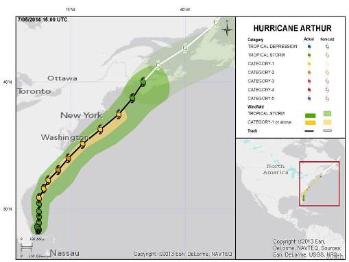
Track and estimated wind history, with the final National Hurricane Center advisory of 11 a.m. EDT (15 UTC) July 5. Hazard data illustrated in the www.i-axs.info for further information.
Meteorological Discussion
Arthur originated from the remnants of a frontal system east of Florida in an enabling environment of low wind shear and warm sea-surface temperatures. Arthur was classified as a tropical depression late June 30 by the National Hurricane Center. Arthur then intensified to a tropical storm twelve hours later on July 1, and then a hurricane early July 3. Arthur reached its peak intensity with maximum sustained winds of 100 mph (160 km/hr) late July 3 before making its first landfall in North Carolina.
Hurricane Arthur made first landfall at about 11:15 p.m. EDT (0315 UTC) as a Category 2 hurricane on the Saffir-Simpson Scale, with maximum sustained winds of 100 mph or 160 km/hr (estimated, over water). Arthur made initial landfall between Cape Lookout and Beaufort, North Carolina before moving over Cedar Island National Wildlife Refuge and then Pamlico Sound, before passing near mainland Dare County and the Northern Outer Banks. Arthur was moving off the Outer Banks as of the 5 a.m. EDT (21 UTC) advisory of the NHC on July 4.
Sustained winds of 77 mph (124 km/hr) were reported at the Cape Lookout NOAA Station, with a gust of 101 mph (163 km/hr). A Weatherflow Station in Waves, North Carolina reported sustained winds of 74 mph (119 km/hr), with gusts to 84 mph (135 km/hr), according to NHC advisories. An estimated storm surge exceeding 4 feet (1.2 m) was reported at Oregon Inlet Marina according to the National Weather Service. At Albermarle Sound, a storm tide (combined surge and normal tide) exceeding 4 feet (1.2 m) was reported. Up to 8 inches (200 mm) of rainfall were reported in some locations.
Arthur is the first hurricane to make U.S. landfall since 2012, and the first Category 2 or higher hurricane to make U.S. landfall since 2008. Arthur also marks the earliest North Carolina landfall for any hurricane season since 1908.
After clearing the North Carolina coast, Arthur phased with and followed a cold low pressure trough as it left the mainland. Arthur continued on a northeasterly track towards New England and Atlantic Canada. During this time, an environment of increasing wind shear and cooler water temperatures caused Arthur to weaken slowly while accelerating the extratropical transition process.
Arthur made closest approach to New England late on July 4, about 75 miles (120 km) from Chatham, Massachusetts. Maximum sustained winds at the time were 75 mph or 120 km/hr (estimated, over water). Sustained winds of 49 mph (79 km/hr) were reported in Nantucket, Massachusetts, with gusts to 62 mph (100 km/hr), according to the NHC. Heavy rainfall was reported in parts of Bristol and Plymouth Counties, with isolated amounts exceeding 7 inches (175 mm) reported, with 8 inches (200 mm) in New Bedford.
Arthur was downgraded to tropical storm status as of 5 a.m. EDT (09 UTC) on July 5 while causing heavy rain and gusty winds in eastern Maine and Atlantic Canada. Rainfall amounts exceeding 6 inches (150 mm) were reported in eastern Maine. Arthur was reclassified by the NHC as a post-tropical cyclone at 8 a.m. EDT (12 UTC) on July 5, after losing tropical characteristics entirely. Maximum sustained winds at the time were 65 mph (105 km/hr).
According to the Canadian Hurricane Centre, Arthur made landfall near Meteghan and Port Maitland, Nova Scotia at about 7:30 a.m. ADT (1230 UTC) July 5, as a post-tropical cyclone. Another landfall was reported at Fundy National Park before the storm lost its identity within the cold low pressure trough. Wind gusts of 84 mph (138 km/hr) were reported in Greenwood, Nova Scotia, 78 mph (128 km/hr) at Brier Island, Nova Scotia, 62 mph (100 km/hr) in Halifax, Nova Scotia and 60 mph (100 km/hr) at Fredrickton, New Brunswick. Over 5 inches (125 mm) of rainfall were reported.
Impacts
North Carolina
Power outages affected about 40,000 people. The storm surge and heavy wave action from both the ocean and sound caused a North Carolina highway to buckle on Hatteras Island, in the same area as Hurricane Irene (2011). Parts of Rodanthe and Salvo were flooded on Friday across nearly the entire width of Hatteras Island from ocean to sound. Reports indicate washed out roads and fallen debris with some roof damage, but officials classified damage as minor.
The Ocracoke Island power distribution system was badly damaged. This prompted officials to order residents to avoid use of air conditioners and water heaters, so that generator supplied power could be used for refrigeration and other necessities during a cycle of planned power outages. A nightly curfew was declared between 10 p.m. and 6 a.m. until power was fully restored. Access to Hatteras Island was briefly restricted, and a bridge was temporarily closed pending engineering inspection.
No injuries or deaths were reported.
Massachusetts
Localized coastal flooding was reported, as well as flash-flooding of some inland areas due to heavy rainfall. Cars were reported floating along streets. Reports indicate power outages affecting about 3,200 customers.
Maine
Downed trees and power lines were reported, with about 19,000 people without power. No injuries were reported.
Vermont
Reports indicate about 1,600 were without power.
Canada
Power outages affected about 250,000 customers, with 141,000 in Nova Scotia and 110,000 in New Brunswick. Downed trees and power lines were reported over a widespread area, including some large trees. Some minor structural damage was also reported as a result of wind.
Sources: Reuters, Associated Press, Wall Street Journal, BBC, Canadian Hurricane Centre, U.S. National Weather Service, CBC, U.S. National Hurricane Center
Guy Carpenter publishes CAT-i reports for major natural catastrophes worldwide. These reports cover catastrophes including worldwide tropical cyclones, earthquakes, major UK and European floods and any other natural event that is likely to incur a significant loss to the (re)insurance industry. Please email CAT.i@guycarp.com if you wish to be added to the free email distribution list.
Guy Carpenter compiles RISK-i reports for major technological or man-made events worldwide. These reports cover risks to property, transport and life including explosions, fires, crashes, engineering disasters and terrorist attacks that are likely to incur a significant loss to the (re)insurance industry. Please email RISK.i@guycarp.com if you wish to be added to the free email distribution list.