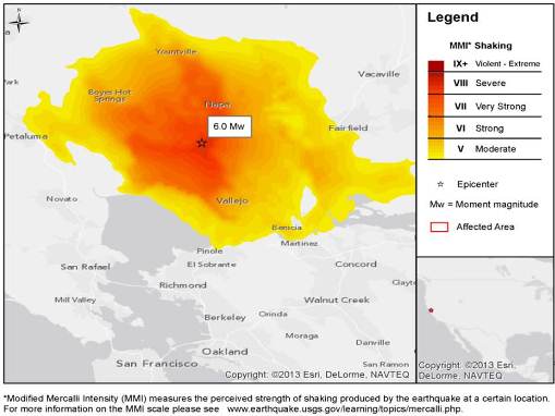

A 6.0-magnitude earthquake was reported by the U.S. Geological Survey (USGS) about 4 miles northwest of American Canyon, California and five miles north-northwest of Napa, California. The quake occurred at 3:20 a.m. local time (10:20 UTC) near the north shore of San Pablo Bay, with a magnitude of 6.0. The quake depth was 7.0 miles (11.3 km).
The earthquake, the largest to hit the area in 25 years, produced no fatalities. However, at least 170 injuries have been reported. Dozens of buildings in the Napa area were damaged. The quake was also responsible for gas and water line breaks, fires, and power outages in the area. Small aftershocks have been reported and are expected to continue for the next several weeks, according to the USGS.

*Modified Mercalli Intensity (MMI) measures the perceived strength of shaking produced by the earthquake at a certain location. For more information on the MMI scale please see www.earthquake.usgs.gov/learning/topics/mercalli.php. Hazard data illustrated in the www.i-axs.info for further information.
Impacts
While ground shaking was felt as far as 200 miles south of Napa and as far east as Nevada, the Napa area was the hardest hit by the earthquake. Governor Jerry Brown declared a state of emergency for Napa, Solana, and Sonoma counties. According to catastrophe model vendor Risk Management Solutions (RMS), extensive unreinforced masonry building and façade damage, plate glass damage, and significant non-structural and contents damage has been observed in the affected area, particularly in downtown Napa. Toppled brick parapets were widespread, according to catastrophe model vendor AIR-Worldwide. Numerous reports of gas and water line breaks have also followed the quake. According to state emergency officials, up to 100 buildings have been deemed unsafe to enter. Fires in a mobile home park destroyed four homes and damaged six others. About 70,000 customers lost power after the quake, although power has now been restored to most customers.
The earthquake was particularly damaging to wineries in the area. Thousands of broken wine bottles and toppled barrels were reported among the damage. It is still too soon to assess the full impact this event will have on contents and business interruption losses for local wineries. Damage was also reported in the city of Vallejo, where 41 buildings were damaged in the downtown area and on Mare Island.
Dozens of aftershocks have hit the area, with the largest measuring 3.6 in magnitude. According to The Northern California Seismic System (NCSS) operated by the University of California at Berkeley and the USGS, there is a 36 percent probability of a strong and possibly damaging aftershock smaller than the main shock within the next seven days, and a 5 - 10 percent probability of an earthquake of equal or greater magnitude. State Geologist John Parrish stated that aftershocks will likely continue for several weeks, however, a large follow-up earthquake would be unlikely.
San Francisco Bay Area state highways and structures have been inspected by the California Department of Transportation and damage appears to have been minor.
According to CoreLogic EQECAT, insured losses for this event could range from USD500 million to USD1 billion, with residential losses contributing approximately one quarter to one half of this loss estimate. It is important to note that there is still considerable uncertainty as to the magnitude of loss at this time, particularly for contents and business interruption losses. Losses to the wine industry could increase this loss estimate.
Sunday's earthquake lies within a 44 mile-wide set of major faults of the San Andreas Fault System, according to the USGS. The earthquake occurred near the West Napa Fault and the Carneros-Green Valley Fault system. The epicenter of the quake is depicted as having a high probability of strong shaking in the future according to the USGS National Seismic Hazard Maps. The area surrounding the quake epicenter is known to experience disproportionately greater damage during historic earthquakes. Since the bayshore areas in the San Francisco Bay region are underlain with landfall and bay mud, this contributes to soil failures and amplified ground shaking.
The earthquake is the largest to hit the area since the 6.9-magnitude Loma Prieta quake in 1989 that killed 63 people and caused USD6 billion in property damage.
Sources: USGS, Reuters News, Associated Press, Agence France Presse, Wall Street Journal, CoreLogic EQECAT, AIR-Worldwide, Risk Management Solutions
Guy Carpenter publishes CAT-i reports for major natural catastrophes worldwide. These reports cover catastrophes including worldwide tropical cyclones, earthquakes, major UK and European floods and any other natural event that is likely to incur a significant loss to the (re)insurance industry. Please email CAT.i@guycarp.com if you wish to be added to the free email distribution list.
Guy Carpenter compiles RISK-i reports for major technological or man-made events worldwide. These reports cover risks to property, transport and life including explosions, fires, crashes, engineering disasters and terrorist attacks that are likely to incur a significant loss to the (re)insurance industry. Please email RISK.i@guycarp.com if you wish to be added to the free email distribution list.