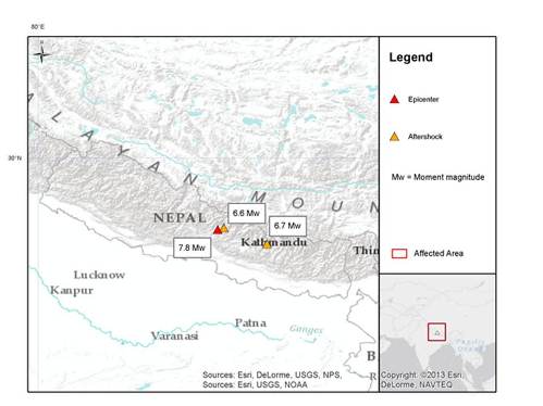

Nepal experienced a magnitude 7.8 earthquake on April 25, 2015, followed by two major aftershocks on April 25 and 26 of magnitude 6.6 and 6.7, respectively, according to the U.S. Geological Survey (USGS). Media reports indicate at least 5,582 fatalities, 11,200 injuries, and at least eight million people affected.
Infrastructure and transportation routes have been severely disrupted and food and water shortages are of great concern. The USGS PAGER service estimates most probable economic losses between USD1 and USD10 billion. It is clear from media reports that impacts have been widespread and of excessive severity and our first thoughts and concerns are with the millions affected by this tragic event.
Geological Background
According to the USGS, the earthquake occurred in a seismically active region called the Himalayan Thrust Front, where the India Plate is converging with or subducting under the Eurasian Plate. The magnitude 7.8 earthquake occurred on or near the main frontal thrust on the subduction zone boundary. The epicenter of this earthquake was approximately 80 kilometers (50 miles) to the northwest of the capital city of Kathmandu.

Location of the April 25 7.8 magnitude earthquake and two major aftershocks. Source: USGS
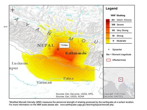
*Modified Mercalli Intensity (MMI) measures the perceived strength of shaking produced by the earthquake at a certain location. For more information on the MMI scale please see www.earthquake.usgs.gov/learning/topics/mercalli.php.
Hazard data illustrated in the CAT-i map was taken from i-aXs®, Guy Carpenter’s web-based risk management platform. i-aXs users can view impacted areas on any map as well as see how their portfolios were affected. Please contact your broker or GC Analytics® representative for assistance or go to www.i-axs.info for further information.
Seismicity in the Himalayas dominantly results from the continental collision of the India and Eurasia plates, which are converging at a relative rate of 40 to 50 millimeters per year. Northward underthrusting of India beneath Eurasia generates numerous earthquakes, and consequently makes this area one of the most seismically hazardous regions on Earth.
The USGS ShakeMap indicates a maximum shaking intensity of "VIII" or "violent" on the Modified Mercali Intensity (MMI) scale, and moderate to heavy damage. According to a report by Nepal's National Society for Earthquake Technology, based on the historical record dating back to 1255, earthquakes in the magnitude 8 range occur approximately every 75 years. The most recent magnitude 8 earthquake in Nepal occurred in 1934.
According to media reports, the Nepal National Seismological Center says that the number and strength of aftershocks have been receding. There have been more than 100 aftershocks since Saturday. The largest of these was a magnitude 6.7 on Sunday. Another magnitude 4.5 aftershock occurred Tuesday morning. Smaller aftershocks are expected to continue for a month and Kathmandu residents could continue to feel tremors because the epicenter was close to the city.
Impacts
It will take time to fully establish the scope and severity of the impacts of this tragic event. Media reports indicate at least 5,582 fatalities and over 11,200 injured in Nepal, according to the Nepal National Emergency Operation Center. It is expected that these numbers will rise as more remote areas closer to the quake epicenter become accessible. In neighboring India, reports indicate 61 fatalities, and the China Xinhua News Agency also reports 25 dead in Tibet. Eighteen others were killed in avalanches on Mount Everest.
A total of 39 districts in Nepal are affected by the earthquake with an estimated eight million people affected, including two million in the 11 most severely affected districts. Significant damage has been reported in Nepal and neighboring areas of northern India, Bangladesh and Tibet. Many historic structures have been destroyed according to media reports.
Transportation routes and infrastructure have been severely disrupted, in part due to landslides following the quake. Media reports indicate that water and food supplies are compromised, especially in outlying areas. Humanitarian aid efforts have been impeded by disrupted transportation routes and area hospitals have been reported as overflowing. Government agencies and health care workers are concerned with sanitation and clean water. Media reports also indicate that the United Nations is releasing USD15 million for quake victims, with priorities of shelter, water, medical supplies and logistical services.
Loss Estimates
The USGS PAGER economic damage service estimates a 76 percent chance that economic losses will exceed USD1 billion, and a 42 percent chance that losses will exceed USD10 billion. The Asia Insurance Review has reported that only a fraction of the losses will be insured according to Kinetic Analysis Corp. The Asia Insurance Review has also reported that the largest reinsurer in Nepal, GIC Re, reported initial loss estimates of USD160 million.
Sources: USGS, UN, BBC, Asia Insurance Review, AXCO, Insurance Information Institute, Xinhua News Agency, CoreLogic/EQECAT
Guy Carpenter publishes CAT-i reports for major natural catastrophes worldwide. These reports cover catastrophes including worldwide tropical cyclones, earthquakes, major UK and European floods and any other natural event that is likely to incur a significant loss to the (re)insurance industry. Please email CAT.i@guycarp.com if you wish to be added to the free email distribution list.
Guy Carpenter compiles RISK-i reports for major technological or man-made events worldwide. These reports cover risks to property, transport and life including explosions, fires, crashes, engineering disasters and terrorist attacks that are likely to incur a significant loss to the (re)insurance industry. Please email RISK.i@guycarp.com if you wish to be added to the free email distribution list.