
Super Typhoon Nepartak made landfall on the southeast coast of Taiwan around 22 UTC on July 7, 2016, before final landfall as a tropical storm on Mainland China around 06 UTC on July 9. Nepartak has rendered significant flood impacts both in Taiwan and Mainland China according to media reports, with at least 10 and three dead in Mainland China and Taiwan, respectively. Flood impacts have been especially severe in Mainland China, which was affected by excessive monsoon rains just prior to Nepartak. Our first thoughts and concerns are with those lost and directly affected.
Meteorological Discussion
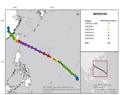
In the West Pacific Basin, Nepartak was first classified as a tropical depression by the Joint Typhoon Warning Center (JTWC) at 00 UTC on July 3, and was soon upgraded to Tropical Storm Status at 20 UTC on July 3. The typhoon was upgraded to typhoon status by the JTWC at 00 UTC on July 5, with one- minute sustained winds of 120 kilometers per hour (74 mph). The storm followed a general west-northwest motion for most of its lifecycle, following the southern edge of the subtropical ridge.
Nepartak track and position reports. Source: Guy Carpenter, Joint Typhoon Warning Center
Hazard data illustrated in the CAT-i map was taken from GC AdvantagePoint®, Guy Carpenter’s web-based risk management platform. GC AdvantagePoint users can view impacted areas on any map as well as see how their portfolios were affected. Please contact your broker or cat modeling analyst for further information.
Over the next 24 hours, Nepartak underwent a period of rapid intensification. This was enabled by warm sea-surface temperatures, reduced wind shear and storm ventilation enhanced by a nearby upper-level low. By 00 UTC on July 6, Nepartak was classified by the JTWC as a super typhoon, with one-minute sustained winds of 260 kilometers per hour (160 mph), equivalent to a Category 5 on the Saffir-Simpson scale.
After this period of rapid intensification, Nepartak strengthened further, with one-minute sustained winds of around 280 kilometers per hour (175 mph) reported by the JTWC at 06 UTC on July 6. Super Typhoon Nepartak maintained this intensity for the next 18 hours while approaching Taiwan, under favorable enabling conditions. During this time, the Japan Meteorological Agency (JMA) estimated a minimum central pressure of 900 HectoPascals (hPa) (millibars (mb)), and a marine observing station remarkably reported an unofficial pressure measurement of 897 hPa (mb).
While nearing Taiwan, Nepartak began to weaken due to increasing wind shear, slightly cooler water temperatures and interaction of the circulation with the topography of Taiwan. According to satellite, radar and JTWC updates, the center of Nepartak made landfall on the southeast coast of Taiwan around 22 UTC on July 7. Prior to landfall, the JTWC reported one-minute sustained winds of 240 kilometers per hour (150 mph) at 18 UTC on July 7, with a minimum central pressure of 930 hPa (mb) reported by the JMA. Nepartak weakened significantly just prior to and during landfall, with severe disruption of circulation over the topography of Taiwan.
While crossing Taiwan, Nepartak produced two-day rainfall amounts of 563 millimeters (22.5 inches) in Hualien County and 490 millimeters (19.6 inches) in Pingtung County, according to the Central Weather Bureau. The excessive rainfall brought the threat of severe flooding and mudslides. Meanwhile, the City of Taitung reported 10-minute sustained winds of 130 kilometers per hour (81 mph) as Nepartak passed to the south. Well after the center of Nepartak cleared Taiwan and emerged into the Taiwan Strait, the JTWC reclassified Nepartak as a tropical storm, with one-minute sustained winds of 110 kilometers per hour (70 mph) at 18 UTC on July 8. The earlier disruption of Nepartak's core prevented strengthening while the storm approached Mainland China.
Nepartak made final landfall on the Fujian Province of Mainland China shortly before 06 UTC on July 9, as a weakening tropical storm, according to JTWC advisories. Following landfall, Nepartak continued to deteriorate into a tropical depression, before dissipating over Mainland China. While crossing into Mainland China, Nepartak brought heavy rainfall to affected areas, with unofficial rainfall amounts of at least 250 millimeters (10 inches) reported in Putian. The rainfall of Nepartak followed earlier periods of excessive monsoon rainfall, which left saturated soils in affected areas. The combined impacts brought severe flooding and mudslides to many areas.
Impacts
In Taiwan, wind impacts and flooding affected central and southern areas. Media reports indicate at least three dead and 300 injured according to emergency management. At least 17,300 were displaced, with up to 517,000 without power according to reports. Nepartak also caused cancellation of trains and at least 640 flights, while work in most of Taiwan was suspended. Initial media reports do not indicate damage to semiconductor plants in southern Taiwan.
In Mainland China, severe flooding and mudslides have been reported in affected areas. Media reports indicate at least 10 dead and 11 missing in Fujian Province according to government officials. At least 1,900 homes are reported destroyed with over 200,000 people relocated. Severe damage to infrastructure, including bridges and roads, has been reported, along with severe auto damage including overturned cars. The severe floods have caused significant crop damage for affected areas, with reports of 16,000 hectares (40,000 acres) of crops destroyed. At least 420,000 people were evacuated ahead of the storm. Five airports were closed, more than 300 trains were cancelled and over 33,000 boats returned to harbor, according to media reports.
Sources: Joint Typhoon Warning Center, Japan Meteorological Agency, Weather Underground, Central Weather Bureau, China Meteorological Administration, Agence France Presse, Reuters.
Guy Carpenter publishes CAT-i reports for major natural catastrophes worldwide. These reports cover catastrophes including worldwide tropical cyclones, earthquakes, major UK and European floods and any other natural event that is likely to incur a significant loss to the (re)insurance industry. Please email CAT.i@guycarp.com if you wish to be added to the free email distribution list.
Guy Carpenter compiles RISK-i reports for major technological or man-made events worldwide. These reports cover risks to property, transport and life including explosions, fires, crashes, engineering disasters and terrorist attacks that are likely to incur a significant loss to the (re)insurance industry. Please email RISK.i@guycarp.com if you wish to be added to the free email distribution list.