
The Bluecut and Clayton fires have caused significant impacts to affected areas and pose an ongoing serious threat to life and property. No serious injuries or deaths have been reported, however, the fires have destroyed multiple structures. Our first thoughts and concerns are with those directly affected by this event.
Bluecut Fire
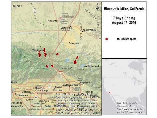
The Bluecut fire poses an immediate threat to life and property. Reports indicate that the fire started Tuesday morning in the vicinity of Cajon Pass near Kenwood Ave., west of Interstate 15, and has since claimed at least 30,000 acres under hot, dry and windy conditions. The fire has spread west to the Los Angeles County line and east to the Mojave Desert according to media reports. The Bluecut fire was zero percent contained as of Wednesday morning.


Source: Wildfire hot spots data retrieved from NASA MODIS ending 5 a.m. MDT, Wednesday.
Hazard data illustrated in the CAT-i map was taken from GC AdvantagePoint®, Guy Carpenter’s web-based risk management platform. GC AdvantagePoint users can view impacted areas on any map as well as see how their portfolios were affected. Please contact your broker or cat modeling analyst for further information.
The U.S. Forest Service estimates at least 34,506 structures are under threat. The San Bernardino County Fire Department confirmed Tuesday night that the Bluecut fire had burned at least a dozen structures, although the full number of affected structures remains unknown. It will take time to assess the scope and severity of impacts as this event evolves.
Mandatory evacuations are in place for the areas of Wrightwood, Oak Hills, Lytle Creek, Cajon Pass, and surrounding areas, to affect at least 82,640 people. Reports also indicate that the Bluecut fire forced closure of part of Interstate 15, stranding commuters and travelers. California's Governor declared a state of emergency in San Bernardino County on Tuesday, according to media reports.
The National Weather Service (NWS) maintains red flag warnings for the area, with the expectation of ongoing hot, dry and windy conditions and poor humidity recovery during the overnight hours.
Clayton Fire
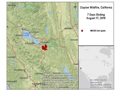
The Clayton fire, located about one mile southeast of Lower Lake, California, has burned at least 3,929 acres since Saturday afternoon. According to Calfire, the fire has claimed at least 175 structures and this number could increase as damage surveys progress. The fire threatens 380 structures and is now 40 percent contained.
Media reports indicate no evident casualties. Mandatory evacuations are in place for Clayton Creek Road, all of Morgan Valley Road, and North Spruce Grove Road to Jerusalem Grade. Reports indicate that the Governor of California issued an emergency declaration for the Clayton fire on Monday. According to media reports, arson is the suspected cause of the fire.
Hot and dry conditions are expected to continue by the NWS. Some cooling is expected into the weekend.
Sources: CalFire, U.S. Forest Service, National Weather Service, Associated Press, Reuters.
Guy Carpenter publishes CAT-i reports for major natural catastrophes worldwide. These reports cover catastrophes including worldwide tropical cyclones, earthquakes, major UK and European floods and any other natural event that is likely to incur a significant loss to the (re)insurance industry. Please email CAT.i@guycarp.com if you wish to be added to the free email distribution list.
Guy Carpenter compiles RISK-i reports for major technological or man-made events worldwide. These reports cover risks to property, transport and life including explosions, fires, crashes, engineering disasters and terrorist attacks that are likely to incur a significant loss to the (re)insurance industry. Please email RISK.i@guycarp.com if you wish to be added to the free email distribution list.