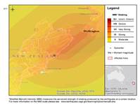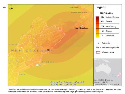

A magnitude (Mw) 7.8 earthquake struck central New Zealand on November 13, 2016, according to the U.S. Geological Survey (USGS). The quake occurred at 11:02 PM local time (11:02 UTC) about 93 kilometers (57 miles) north-northeast of Christchurch and about 215 kilometers (133 miles) southwest of Wellington.
According to government officials, at least two fatalities have been reported. The earthquake damaged roads and buildings and triggered a tsunami warning that led to mass evacuations along the eastern coast of New Zealand. According to the USGS, at least 51 seismic events have been recorded since the initial earthquake struck, with some reported as strong as the initial quake. Our first thoughts and concerns are with those directly affected by this event.

Reference points to earthquake location:
53 km (32 mi) NNE of Amberley, New Zealand
77 km (47 mi) NNE of Kaiapoi, New Zealand
93 km (57 mi) NNE of Christchurch, New Zealand
155 km (96 mi) SSW of Blenheim, New Zealand
215 km (133 mi) SW of Wellington, New Zealand
Hazard data illustrated in the CAT-i map was taken from GC AdvantagePoint®, Guy Carpenter’s web-based risk management platform. GC AdvantagePoint users can view impacted areas on any map as well as see how their portfolios were affected. Please contact your broker or cat modeling analyst for further information.
Impacts
It will take time to fully establish the scope and severity of the impacts of this event. According to government officials, two fatalities have been reported. While the death toll is expected to remain low, the earthquake caused damage to major parts of New Zealand's infrastructure, according to media reports.
A state of emergency was declared for the Kaikoura region, a popular tourist destination near the epicenter of the earthquake. Injuries and one death were reported due to collapsed buildings. According to media reports, landslides have made the town inaccessible, with telecommunications, water and power supplies disconnected. Military helicopters and a navy ship have been sent to evacuate more than 1,000 stranded residents. Rescue efforts are expected to take several days, with poor weather conditions expected to hamper efforts, according to rescue officials. New Zealand Prime Minister John Key toured the area and estimated that the cleanup effort could be in the billions of dollars and take months to accomplish.
Residents near the Clarence River, one of the largest on South Island, were urged to move immediately to higher ground after debris from landslides caused the river to breach its banks.
Damage was also reported in Wellington, the capital of New Zealand. According to media reports, workers have been ordered to stay home as local officials assess damage to buildings. Some large buildings have shown signs of structural stress, according to local officials. Broken windows and a collapsed ferry loading ramp were also reported. The city's suburban rail network was shut down in order for crews to check the safety of tracks, bridges and tunnels.
A tsunami warning led to mass evacuations after large waves hit the cities of Wellington and Christchurch. Law enforcement reported 19 burglaries of homes and commercial properties in the area around Christchurch during the evacuation. Authorities have lifted the warning, but caution people to stay away from the shoreline.
Aftershocks have left some communities without power and water. According to the USGS, at least 51 seismic events have been recorded in the area over the last day, with one event measuring Mw 6.5.
Shaking was felt in Christchurch, where residents stocked up on basic supplies. Some schools in the area remained closed on Monday. The area is still recovering from the Mw 6.3 earthquake in 2011 that killed 185 people.
Markets in the country traded normally despite many offices in the capital being closed. The New Zealand dollar recovered after initially falling to a one-month low.
The world's biggest dairy exporter, Fonterra, reported that some of its farms were without power and may have to discard milk.
Physical Discussion
According to the USGS, the earthquake occurred as a result of shallow faulting on or near the boundary between the Pacific and Australia plates in South Island, New Zealand. In this area, the Pacific plate moves to the west-southwest with respect to the Australia plate at a rate of 40 millimeters (1.6 inches) per year.
The complexity of the event, involving a delayed main energy release, along with an early aftershock distribution extending about 150 kilometers (93 miles) to the north-northeast of the main shock, suggests the potential of a triggered slip on the Pacific-Australia subduction zone interface.
The Pacific-Australia plate boundary in northern South Island has a history of large earthquakes. According to the USGS, the November 13, Mw 7.8 earthquake is the largest event in the area since 1929, when a Mw 7.3 earthquake hit 100 kilometers (62 miles) to the northwest.
Sources: USGS, Reuters News, Associated Press, BBC News, New York Times
Guy Carpenter publishes CAT-i reports for major natural catastrophes worldwide. These reports cover catastrophes including worldwide tropical cyclones, earthquakes, major UK and European floods and any other natural event that is likely to incur a significant loss to the (re)insurance industry. Please email CAT.i@guycarp.com if you wish to be added to the free email distribution list.
Guy Carpenter compiles RISK-i reports for major technological or man-made events worldwide. These reports cover risks to property, transport and life including explosions, fires, crashes, engineering disasters and terrorist attacks that are likely to incur a significant loss to the (re)insurance industry. Please email RISK.i@guycarp.com if you wish to be added to the free email distribution list.