
Hurricane Harvey made landfall around 11 p.m. EDT, August 25, 2017, on the Texas coastline between Port Aransas and Port O'Connor. The hurricane made landfall as a rare Category 4 hurricane on the Saffir-Simpson Scale, with maximum sustained winds of 130 mph and a minimum central pressure of 938 millibars (mb). Harvey then moved inland and began to drift with weak or absent steering currents over subsequent days. Harvey produced significant wind impacts near the immediate impact area along with a considerable storm surge. The slow motion of the weakening hurricane also produced bands of thunderstorms that produced very heavy rainfall over southeast Texas. These rainfall amounts, well in excess of 20 inches for certain areas, have produced catastrophic flood impacts over southeast Texas including the Houston metro area. Impacts include light to moderate wind and tornado damage with downed trees and powerlines, along with flood impacts of variable severity, and significant impact reports from the Houston metro area. Damage to local infrastructure in affected areas has been reported. The storm has caused at least six fatalities according to media reports.
Harvey was expected by the National Hurricane Center (NHC) to slowly turn to the northeast while maintaining tropical storm status, passing close to the Houston area. The heavy rainfall is expected to continue over the coming days, compounding the flood threat in southeast Texas and southwest Louisiana including the Houston metro area.
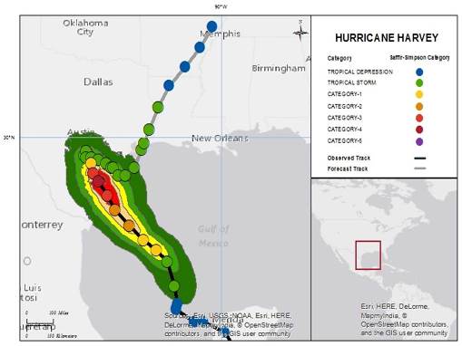
Tropical Storm Harvey track and estimated winds; Source: Guy Carpenter, National Hurricane Center
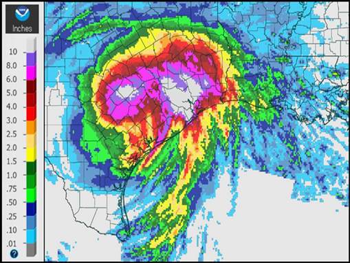
Radar-Estimated Precipitation - 24 Hours Ending 8 a.m. EDT (12 UTC) Monday, August 28; Source: NOAA/NWS
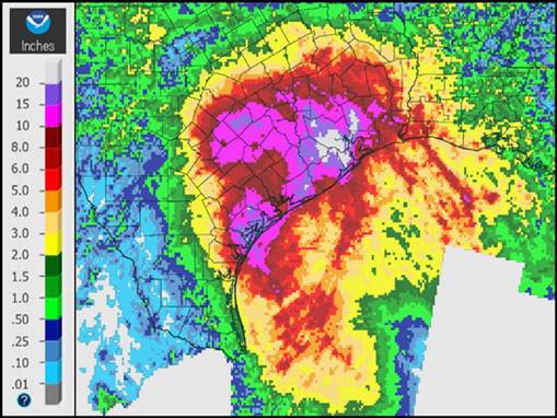
Radar-Estimated Precipitation - 7-Days Ending 8 a.m. EDT (12 UTC) August 28; Source: NOAA/NWS
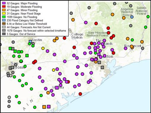
Forecast River Gauge Flood Status Map; Source: NOAA/NWS/AHPS
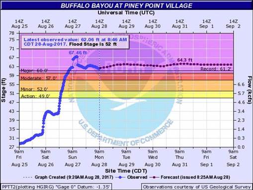
River Gauge Observed and Forecast - Buffalo Bayou at Piney Point Village; Source: NOAA/NWS/AHPS
Hazard data illustrated in the CAT-i map was taken from GC AdvantagePoint®, Guy Carpenter’s web-based risk management platform. GC AdvantagePoint users can view impacted areas on any map as well as see how their portfolios were affected. Please contact your broker or cat modeling analyst for further information.
Harvey is the first major hurricane to make U.S. landfall since Hurricane Wilma (2005), and the first Category 4 hurricane to affect Texas since Hurricane Carla (1961). The last hurricane to make Texas landfall was Hurricane Ike (2008), a strong category two hurricane.
Our first thoughts and concerns are with those directly affected by this event.
Meteorological Discussion
After redeveloping from a tropical wave in the western Gulf of Mexico, Hurricane Harvey developed into a major hurricane while approaching the Texas coast due to warm water and reduced wind shear. According to NHC advisories, maximum sustained winds prior to landfall reached 140 mph, a Category 4 hurricane on the Saffir-Simpson Scale. Minimum central pressure dropped to 938 mb during this time. While approaching the Texas coast, Harvey was able to develop a significant storm surge along affected areas of the Texas coast due to both increasing winds and decreasing pressure.
Harvey made landfall around 11 p.m. EDT on August 25 (03 UTC August 26) between Port Aransas and Port O'Connor, Texas. At the time of landfall, hurricane and tropical storm force winds extended outward from the center of circulation to 40 and 140 miles, respectively. Harvey then made a second landfall on the northeastern shore of Copano Bay with maximum sustained winds of 125 mph, a Category 3 hurricane on the Saffir-Simpson Scale. During this time, sustained winds of 111 mph were observed at Aransas Pass, Texas, with gusts to 131 mph. An observed tide of 6.6 feet above mean higher high water was observed at Port Lavaca, Texas, according to NHC advisories.
Following landfall, Harvey weakened quickly due to land interaction as it moved inland. During this time, steering currents collapsed in between two adjacent high pressure areas. With nothing to guide the storm, the center of Harvey then meandered over southeast Texas over the subsequent few days as a weak tropical storm. The slow, meandering motion of Harvey has since allowed lines of showers and thunderstorms to be drawn from the warm waters of the Gulf of Mexico to slowly progress eastward through southeast Texas. In addition to an ongoing tornado threat, these rain bands have produced excessive rainfall amounts over large areas of southeast Texas. Rainfall amounts to date include:
- 24.79 inches for Houston Intercontinental Airport,
- 7.96 inches at Austin International Airport,
- 30.56 inches at Berry B Forest Oaks, and
- 5.49 inches at Lake Charles Municipal Airport.
These excessive rainfall amounts have produced significant and impactful flood and flash-flood impacts over southeast Texas to include the Houston metro area.
As of Monday, a poorly organized Harvey is still producing bands of very heavy rainfall over southeast Texas and into southwestern Louisiana. As a ridge of high pressure builds to the south and east, the resulting steering currents should cause Harvey to turn to a north-northeasterly direction through tomorrow, after which Harvey should make landfall again before moving into northern Louisiana and southern Arkansas through the end of the week. Model guidance is beginning to converge on such a scenario, but still with considerable spread. Accounting for these factors, the NHC best forecast takes Harvey back inland, just west of Galveston Wednesday morning and then into northern Louisiana for Thursday, and then southern Arkansas by Friday.
Concerning intensity, Harvey appears fairly disorganized and will be impeded by wind shear and land interaction, but still with access to warm Gulf waters. Accounting for these factors, the NHC is expecting Harvey to retain tropical storm status without significant redevelopment through Thursday. The current NHC forecast is that Harvey will be downgraded to tropical depression status on Friday.
Over the coming days, Harvey will continue to produce bands of very heavy rainfall over southeast Texas and southwest Louisiana. As these bands cross already flooded areas, the existing flood threat will be compounded, and the threat of tornadoes will continue. Most gauges in southeast Texas still indicate major flood stage, with historical flood stage either reported or expected for certain stations including the Buffalo Bayou in the Houston area.
An additional 20 to 25 inches of rainfall is expected by the NWS to produce isolated storm-totals of 50 inches for certain areas. This will worsen the existing flood threat and also cause potential flood impacts for southwest Louisiana. It is possible that dry air wrapping on the west side of Harvey may lessen rainfall intensity for southeast Texas and the Houston area by Wednesday morning, with a further reduction in rainfall intensity as Harvey moves inland later in the week.
Impacts
Harvey has been blamed for at least eight fatalities and 14 injuries since making landfall as a Category 4 hurricane, according to media reports. Our first thoughts and concerns are with those directly affected by this event.
In Rockport, Texas, a town of about 9,000 residents, the mayor reported widespread devastation, including heavily damaged homes, businesses and schools. Hundreds of roofs were severely damaged and thousands of windows have been blown out, according to media reports. Several roads were impassable due to downed power lines. Ten people were injured when a roof collapsed at a senior living complex. More than 120 people were evacuated from a hotel after the hotel suffered severe damage. According to media reports, officials believe as many as nine people are still missing in Rockport, with some 30 to 40 people missing in Aransas County. Harvey made landfall very near the town of Rockport as a Category 4 hurricane.
No water service and limited power was reported by media in the town of Victoria, about 90 miles north of Rockport and with a population of 85,000. Local authorities released a statement cautioning residents that power may take several days to weeks to restore and that damage was widespread throughout the town.
In the town of Fulton, nearly every house sustained damage according to local authorities as reported by media. In Port Aransas, a population of about 4,000, severe damage prevented law enforcement from being able to fully survey the town.
Reports indicate that evacuees have been allowed to return to Corpus Christi; however, city officials warned residents that a water boil advisory was in place. Downed trees and power lines, scattered debris, some roof damage, and widespread power outages were reported, however, damage in the town was less than initially expected.
Houston, Texas has experienced historic flooding, with rivers swelling to record levels. Schools, airports and office buildings were closed on Monday due to the flooding. The Houston Independent School District closed all schools and offices for the week due to Harvey. Federal engineers released water from area reservoirs on Monday to control the rushing currents. Local officials from Harris County expect flooding for homes around the Addicks and Barker reservoirs as a result. More flooding is expected in the city as the rainfall continues.
The Federal Emergency Management Agency (FEMA) stated that as many as 50 counties in Texas are affected by the flooding. Nearly 30,000 people have sought refuge in temporary shelters. The Red Cross prepared to take in 1,200 evacuees at Houston's convention center. Officials in Dallas are turning a convention center into a shelter to take in as many as 5,000 evacuees. FEMA expects as many as 450,000 people to seek disaster assistance due to flooding from Harvey.
More than 3,000 National Guard and State Guard members were activated by Sunday morning, according to government officials, with another 1,000 members expected to arrive in Houston on Monday to assist with the flooding disaster relief.
Emergency and disaster relief crews from several states arrived in Aransas County to assist in disaster relief. According to local officials, no running water, power or phone service is available. Natural gas has also been cut off.
Nearly 300,000 homes and businesses were without power in Texas, which could last several days, according to local officials.
The coast guard rescued 20 people from boats in distress, according to the commander of the Corpus Christi sector. The port in Corpus Christi remains closed due to damage. The port is the third-largest petrochemical port in the country.
In Fort Bend County, officials ordered mandatory evacuations along the Brazos River levee districts. Authorities are expecting the Brazos River to reach major flood stages. Local officials have expressed concerns of a levee failure given expected river rise. Three state prisons were evacuated near the Brazos River due to flooding concerns.
Gasoline futures spiked to their highest level in more than two years in early Monday trading in Asia due to concerns of storm impact. Outages will reduce the supply of U.S. crude, gasoline, and other refined products and further increase prices, according to analysts. The federal government has not stated whether it plans to release barrels of oil from the Strategic Petroleum Reserve, which was established in the 1970s to prevent supply shocks.
Full damage assessments could take several days to weeks to complete, according to authorities. An emergency request for Louisiana was made on Monday, where severe flooding is expected. Five parishes in southwest Louisiana were issued federal emergency declarations, according to media reports.
Sources: Washington Post, Reuters, Associated Press, National Hurricane Center, National Weather Service, The Weather Channel
Click here to read the previous update on this event>>
Guy Carpenter publishes CAT-i reports for major natural catastrophes worldwide. These reports cover catastrophes including worldwide tropical cyclones, earthquakes, major UK and European floods and any other natural event that is likely to incur a significant loss to the (re)insurance industry. Please email CAT.i@guycarp.com if you wish to be added to the free email distribution list.
Guy Carpenter compiles RISK-i reports for major technological or man-made events worldwide. These reports cover risks to property, transport and life including explosions, fires, crashes, engineering disasters and terrorist attacks that are likely to incur a significant loss to the (re)insurance industry. Please email RISK.i@guycarp.com if you wish to be added to the free email distribution list.