
Hurricane Harvey posed an active threat to the Texas coast as a major hurricane. According to the 3 p.m. EDT National Hurricane Center (NHC) position advisory, Hurricane Harvey carries maximum sustained winds of 120 mph, a Category-3 hurricane on the Saffir-Simpson Scale. Harvey is located about 75 miles southeast of Corpus Christi, Texas, and is approaching the coast on a northwesterly track at 10 MPH. The central pressure has dropped to 943 millibars (mb), and this likely will bring further increase in winds prior to landfall. Harvey is expected to make landfall on the Texas coast late Friday into early Saturday as a major hurricane. Tropical storm conditions are already well underway for certain areas of the Texas coast according to the NHC. Following landfall, Harvey is expected by the NHC to weaken and meander eastward along the Texas coast next week.
Heavy rainfall well into next week will produce excessive rainfall amounts of 20 to 25 inches for certain areas. This will bring a threat for significant and potentially devastating flooding and flash-flooding for certain areas. Impacts due to wind can also be expected to inflict, at minimum, downed trees and powerlines with light to moderate property damage, with more severe impacts adjacent and to the right of the storm track. A significant storm surge will also affect areas of the Texas coast to cause significant property and infrastructure impacts for immediate coastal areas. Official watches and warnings have been issued for areas under threat.

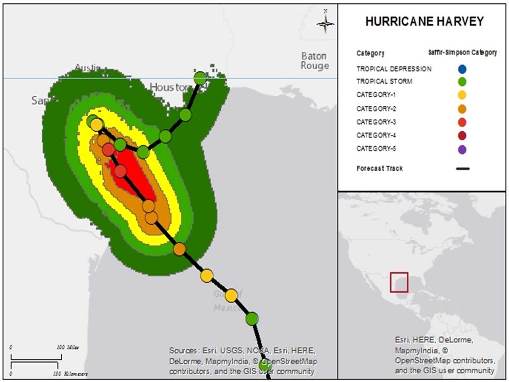
Hurricane Harvey track and forecast winds. SOURCE: Guy Carpenter, National Hurricane Center.
Hazard data illustrated in the CAT-i map was taken from GC AdvantagePoint®, Guy Carpenter’s web-based risk management platform. GC AdvantagePoint users can view impacted areas on any map as well as see how their portfolios were affected. Please contact your broker or cat modeling analyst for further information.
Meteorological Discussion
After redeveloping from a tropical wave in the western Gulf of Mexico, Harvey has since developed into a Category-3 hurricane on the Saffir-Simpson Scale. The hurricane is still showing signs of strengthening, evidenced by a continuing drop in central pressure and increasing winds. Some further intensification prior to landfall may still occur given warm waters and reduced wind shear, although increasing land interaction will act to suppress the rate of development. Harvey should make landfall late tonight or early tomorrow as a Category-3 hurricane on the Saffir-Simpson Scale. Tropical storm wind conditions are already well underway for areas of the Texas coast according to the NHC.
Harvey is continuing to build a significant storm surge as expected by the NHC, with forecast water heights above ground of up to 12 feet for some areas.
Harvey should follow steering currents in a general northwest direction for the near-term prior to landfall, with a drastic reduction in speed over the coming hours as steering currents collapse between two other high pressure areas. Following landfall, Harvey should weaken considerably before meandering to the east well into next week. Several forecast scenarios take Harvey back into the Gulf before moving back inland next week as a possible tropical storm.
The slow movement of Harvey will allow heavy rainfall to persist over a very large area well into next week. Rainfall amounts will be excessive and amplify the threat for flooding and flash-flooding in affected areas.
Expected Hazards
Harvey is expected to render hazards of wind, storm surge with excessive rainfall and flooding to affected areas. The NHC and National Weather Service have both issued watches and warnings for areas under potential or immediate threat.
Wind
Hurricane wind conditions are likely within the hurricane warning area later today and tonight, with tropical storm conditions expected to first reach the coast in the hurricane warning area later this morning. These conditions are likely to persist into Saturday in portions of the hurricane and tropical storm warning area.
Probable impacts for affected areas include, at minimum, light to moderate damage to roof and wall materials due to windborne debris, and vehicle damage. Damage of higher severity is possible adjacent and to the right of the track. Affected high rise structures may also experience damage with higher wind speeds at elevation. Impacts further inland will include downed trees and powerlines over widespread areas with some light to moderate structural damage. More severe impacts can be expected for properties that are old or of less resilient construction.
Rainfall
Harvey is expected to produce total rain accumulations of 15 to 25 inches and isolated maximum amounts of 35 inches over the middle and upper Texas coast through next Wednesday. During the same time period Harvey is expected to produce total rain accumulations of seven to 15 inches in far south Texas and the Texas Hill Country eastward through central and southwest Louisiana, with accumulations of up to seven inches extending into other parts of Texas and the lower Mississippi Valley.
Rainfall from Harvey is expected by the NHC to cause "life-threatening and devastating flooding." Flood waters in affected areas can be expected to affect properties in typically flood-prone areas as well as areas adjacent that do not normally flood. Damage of property and contents due to inundation, as well as potentially severe structural damage due to water velocity is probable, along with severe to complete damage to affected vehicles. Flood impacts can be expected to occur over widespread areas.
Storm Surge
The combination of a dangerous storm surge and the tide will cause normally dry areas near the coast to be flooded by rising waters moving inland from the shoreline. The water is expected to reach the following heights above ground if the peak surge occurs at the time of high tide:
- N Entrance Padre Island Natl Seashore to Sargent...six to 12 feet
- Sargent to Jamaica Beach...five to eight feet
- Port Mansfield to N Entrance Padre Island Natl Seashore...five to seven feet
- Jamaica Beach to High Island...two to four feet
- Mouth of the Rio Grande to Port Mansfield...two to four feet
- High Island to Morgan City...one to three feet
The deepest water will occur along the immediate coast near and to the northeast of the landfall location, where the surge will be accompanied by large and destructive waves. Surge-related flooding depends on the relative timing of the surge and the tidal cycle, and can vary greatly over short distances. Local NWS products will have more detail for specific areas.
These storm surge levels, together with battering waves, will be life-threatening and render significant to complete damage to coastal properties, and those located on connected waterways, bays and inlets. Considerable damage to civil infrastructure is also probable with this hurricane, including transportation, power, water and sanitary systems, with greatest severity adjacent and to the right of the track. Damage to energy infrastructure along the Gulf coast is also probable and will depend on the timing of landfall together with the timing of local tidal effects.
Tornadoes
Isolated tornadoes are possible across portions of the middle and upper Texas coast today. These tornadoes can render considerable property damage for affected structures.
Impacts
Tropical storm conditions have already started to affect certain areas of the Texas coast, according to the NHC, and conditions continue to deteriorate. Water levels of at least one to two feet above average tide levels have already been reported this morning from South Padre Island, Texas, to Calcasieu Pass, Louisiana.
Mandatory evacuations have been ordered for seven Texas counties along the coast from Corpus Christi to the western end of Galveston Island, according to media reports. Voluntary evacuations have been ordered for Corpus Christi and the Bolivar Peninsula. State transportation officials were considering turning all evacuation routes to one-way traffic heading inland before the storm hits, according to media reports.
Texas Governor Greg Abbott declared a disaster for 30 Texas counties and urged residents to prepare for the storm. The governor activated 700 members of the National Guard ahead of Harvey's landfall in preparation for search and rescue missions and emergency evacuations, according to media reports.
Dozens of schools along the coast of Texas have cancelled classes. Texas A&M University-Corpus Christi issued an evacuation of the campus and announced the campus would close by noon on Thursday. The Houston Independent School District announced on Friday morning that all schools and administrative offices would be closing immediately.
More than 200,000 students were impacted by the closure. Several college campuses in the Houston-area have cancelled classes for Friday, according to media reports.
At least 40 flights have been cancelled in and out of major airports in Texas on Friday. Officials at Houston-area airports expect to remain open after the storm makes landfall, but airlines are encouraging passengers to change travel plans, according to media reports. Weather conditions may impede air travel well after the storm makes landfall given the expected track and slow movement.
Oil and gas operations have already been disrupted, causing a spike in gasoline prices.
More than 45 percent of U.S. refining capacity is along the Gulf Coast. Ports from Corpus Christi to Texas City, Texas, were shut down to incoming vessels.
The US Navy has closed Naval Air Station Corpus Christi until further notice and issued an evacuation of all non-essential active-duty military personnel.
The Driscoll Children's Hospital in Corpus Christi airlifted at least ten critically ill patients to the Cook Children's Hospital in Fort Worth.
A state of emergency has been declared for Louisiana. The Cameron Parish Office of Emergency Preparedness issued a mandatory evacuation for the area, including the towns of Hackberry, Johnson Bayou, Holly Beach, Cameron, Creole, Grand Chenier and Big Lake. Heavy rainfall is expected in the New Orleans area, which could challenge the city's flood drainage pumping system. According to media reports, only 105 of the 120 water pumps in the city are operational. The Federal Emergency Management Agency was assisting the flood pump system for the city.
Sources: Reuters, Associated Press, National Hurricane Center, National Weather Service, The Weather Channel.
Guy Carpenter publishes CAT-i reports for major natural catastrophes worldwide. These reports cover catastrophes including worldwide tropical cyclones, earthquakes, major UK and European floods and any other natural event that is likely to incur a significant loss to the (re)insurance industry. Please email CAT.i@guycarp.com if you wish to be added to the free email distribution list.
Guy Carpenter compiles RISK-i reports for major technological or man-made events worldwide. These reports cover risks to property, transport and life including explosions, fires, crashes, engineering disasters and terrorist attacks that are likely to incur a significant loss to the (re)insurance industry. Please email RISK.i@guycarp.com if you wish to be added to the free email distribution list.