
Hurricane Maria has affected areas of the Caribbean as a severe Category 4 or 5 hurricane, rendering severe damage due to wind and flood to areas including Dominica, Saint Croix and Puerto Rico. At least seventeen fatalities have been reported by media along with 20 missing and these numbers may rise as the most severely damaged areas become accessible. Severe to complete damage has been reported in Dominica. Variable damage to property and infrastructure has been reported in Puerto Rico, and power and drinking water have been compromised, with media reports that the entire island is without power. Our first thoughts and concerns are with those lost and directly affected by this event.
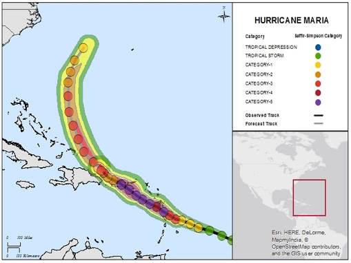
Maria retains status as a major hurricane as it moves along the coast of the Dominican Republic. The hurricane is expected by the National Hurricane Center to move toward the Turks and Caicos Islands and the Southeastern Bahamas before moving into the Atlantic between the U.S. Mainland and Bermuda.

Hurricane Maria track and estimated winds (observed and forecast); Source: Guy Carpenter, NOAA/NHC.

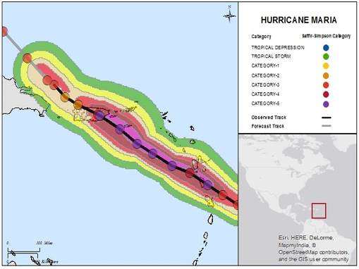
Hurricane Maria track and estimated winds (observed only); Source: Guy Carpenter, NOAA/NHC.
Hazard data illustrated in the CAT-i map was taken from GC AdvantagePoint®, Guy Carpenter’s web-based risk management platform. GC AdvantagePoint users can view impacted areas on any map as well as see how their portfolios were affected. Please contact your broker or cat modeling analyst for further information.
Meteorological Discussion
Advisories on the tropical disturbance that became Maria were first initiated by the National Hurricane Center (NHC) when the feature was about 755 miles east-southeast of the Lesser Antilles. Maria was first classified by the NHC as a potential tropical cyclone at 11 a.m. EDT (15 UTC), September 16. The feature then organized into a tropical depression and then gained intensity to be classified as a tropical storm by the NHC at 5 p.m. EDT (21 UTC), September 16. Maria continued to gain strength and was upgraded to hurricane status by the NHC at 5 p.m. EDT (21 UTC), September 17, while Maria was about 140 miles east-northeast of Barbados.
Over the next 24 hours, Maria underwent a period of rapid intensification over warm waters and in a low-shear environment. By 5 p.m. EDT (21 UTC), September 18, Maria carried maximum sustained winds of 130 mph, a Category 4 hurricane on the Saffir-Simpson Scale, with a minimum central pressure of 950 millibars (mb). Maria then continued to gain intensity while on approach to Dominica. Maria strengthened to a Category 5 hurricane by 7:45 p.m. EDT (23:45 UTC), September 18, with maximum sustained winds of 160 mph. The eye of Maria made landfall over Dominica around 9:35 p.m. EDT, September 18 (01:35 UTC, September 19), with maximum sustained winds of 160 mph, and a central pressure of 924 mb. The center of Maria then cleared Dominica to then approach the Virgin Islands and Puerto Rico.
Hurricane Hunter aircraft reconnaissance then revealed that Maria continued to strengthen, as the outer rain bands moved across the Virgin Islands and Puerto Rico at 3 p.m. EDT (19 UTC), September 19, bringing tropical storm force wind gusts. At 7 p.m. EDT (23 UTC), September 19, Maria was found by the NHC to carry maximum sustained winds of 175 mph, with a central pressure of 909 mb, while the center was about 70 miles southeast of Saint Croix. Sustained hurricane force winds were reported on Saint Croix at 12 a.m. EDT (04 UTC), September 20, and the outer eyewall affected Saint Croix according to the NHC at 1 a.m. EDT (05 UTC), September 20, while the center was located about 20 miles southwest of Saint Croix. Sustained winds of 106 mph were reported by the NHC during this time. Maria then began to weaken somewhat while moving toward Puerto Rico, as the eyewall passed over Vieques at around 4 a.m. EDT (08 UTC), September 20.
The center of Maria then made landfall near Yabucoa, Puerto Rico, around 6:35 a.m. EDT (10:35 UTC), according to the NHC. Maria is the most severe hurricane to affect Puerto Rico since 1928. Maximum sustained winds at landfall were 155 mph, a severe Category 4 on the Saffir-Simpson Scale, with a central pressure of 917 mb. Maria then rendered severe wind impacts to certain areas of the island. The hurricane also produced excessive rainfall amounts, perhaps amplified by the topography of Puerto Rico. Preliminary, unofficial rainfall amounts exceeding 15 inches were reported, with localized amounts exceeding 30 inches. These rainfall amounts produced severe flooding and flash-flood impacts for areas of the island. While crossing the island, Maria was disrupted due to land interaction and topography and by 2 p.m. EDT (18 UTC), September 20, the center of Maria was just offshore of the northwestern coast of Puerto Rico. By this time, Maria had weakened to a Category 2 hurricane with maximum sustained winds of 115 mph, and central pressure of 961 mb.
By 2 a.m. EDT (18 UTC), September 21, Maria had regained status as a category three hurricane, with maximum sustained winds of 115 mph, and a central pressure of 959 mb, while passing about 55 miles north of Punta Cana, Dominican Republic. Maria brought the threat of tropical storm and hurricane conditions to the northern coast of the Dominican Republic, along with ongoing heavy rainfall to Puerto Rico. Maria then began to move away from the Dominican Republic and towards the Turks and Caicos Islands and the Southeastern Bahamas the afternoon of September 21, while gaining intensity. Hurricane and tropical storm watches and warnings remain in effect for areas under potential or immediate threat, for hazards including hurricane wind conditions, storm surge as high as nine to 12 feet and heavy rainfall to produce the threat of flash-flooding and mudslides.
Impacts
It will take some time to fully assess the scope and severity of impacts from this event. Media reports indicate at least 17 fatalities with 20 missing in the Caribbean as a result of Hurricane Maria, although this number could well rise as the most severely damaged areas become accessible. Initial reports show widespread damage for areas affected by the storm, with especially severe damage in Puerto Rico, Dominica and St. Croix.
Puerto Rico
Impacts due to wind and flooding have been especially severe according to media reports. Wind-borne debris including metal roof materials and broken window fragments were reported as the storm was about to make landfall. Emergency officials have reported that 100 percent of the island is without power and damage to power infrastructure has been reported. Drinking water has also been compromised for certain areas. Area river levels approached or exceeded record levels due to excessive rainfall; however, water levels are expected to recede as the storm continues to move away from the island. Water rescues have been reported in Levittown, east of San Juan, for dozens of families stranded on rooftops. Reports have yet to emerge from certain areas of the island affected by the core of the hurricane, where especially severe damage is probable. Meanwhile, the U.S Coast Guard is searching for a missing boat named the "Ferrel," following distress calls after the boat went adrift near Vieques, Puerto Rico.
San Juan experienced substantial damage to property and infrastructure due to wind and flash-flooding. Reports of wind damage to roof and wall materials are widespread, including localized areas with more substantial to complete damage. Flood impacts are ongoing. The streets of historic Old Town were scattered with broken balconies, shattered lamp posts, and downed power lines. According to local officials, half the city was flooded Wednesday and power could take four to six months to restore. Evacuees sheltering in the Roberto Clemente Coliseum in San Juan were forced to the second and third floors due to floodwaters, and the exterior roof of the facility suffered damage due to wind. The Juan Matos neighborhood of the San Juan suburb of Catano lost 80 percent of its homes, according to media reports. Significant damage has also been reported for areas including Cucharilla, Puente Blanco and La Puntilla.
Dominica
Media reports indicate that the island of Dominica has suffered significant to complete damage to property and infrastructure. The Caribbean Disaster Emergency Management Agency estimates 70 to 80 percent damage to building stock with damage also to the hospital, roads and bridges. Communications remain sporadic and damage reports are only beginning to come in. Communication with the island is limited only to satellite phones and HAM radio operators, and has otherwise been disrupted. At least seven fatalities have been reported by media, and this number is expected to rise as damage survey efforts continue.
Saint Croix
Initial reports indicate damage due to wind and flood, with reports of damaged roofs, compromised buildings and downed trees. The full extent and severity of damage remains unclear; however, severe wind impacts are probable given the interaction of the core of the hurricane with the island.
Dominican Republic
Heavy rainfall and strong winds have affected the northeast cost of the Dominican Republic. Expected impacts include light to moderate property damage, especially for those properties previously affected by Hurricane Irma, along with flood and flash-flood impacts due to heavy rainfall. A storm surge as high as four to six feet was expected by the NHC.
Sources: Reuters, U.S. National Hurricane Center, U.S. National Weather Service, The Weather Channel, AIR Worldwide, Risk Management Solutions
Guy Carpenter publishes CAT-i reports for major natural catastrophes worldwide. These reports cover catastrophes including worldwide tropical cyclones, earthquakes, major UK and European floods and any other natural event that is likely to incur a significant loss to the (re)insurance industry. Please email CAT.i@guycarp.com if you wish to be added to the free email distribution list.