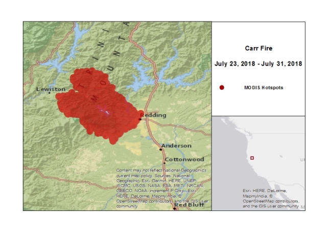
In Northern California, the Carr Fire has burned at least 110,154 acres since July 23, 2018, and claimed at least six lives according to media reports and Cal Fire. Damage survey efforts are still ongoing, however initial indications are that at least 1,236 structures have been destroyed with another 225 damaged.
At least 27,000 people have been displaced by this event. Ongoing hot conditions are expected for the area which will continue to enable active fire spread. Nevertheless, containment efforts have made headway and the fire is under 27 percent containment according to Cal Fire.
The fire continues to pose an active threat to numerous structures along with power and communications infrastructure, and evacuations remain in place. Our thoughts and concerns remain with those lost and personally affected by this event.
Event Background
The Carr Fire was ignited midday on July 23, 2018, approximately 20 miles northwest of Redding, California, according to Cal Fire and media reports.
The cause of the fire has since been identified by Cal Fire as 'Mechanical Failure of Vehicle'. At the time of ignition, fire potential in the region was high due to hot and dry conditions; high temperatures in Redding exceeded 100 degrees F in the days prior to ignition, and much of Shasta County is under 'Abnormally Dry' or 'Moderate Drought' conditions according to the U.S. Department of Agriculture.

Hazard data illustrated in the GC AdvantagePoint users can view impacted areas on any map as well as see how their portfolios were affected. Please contact your broker or cat modeling analyst for further information.
Fire growth was moderate during the first days of the fire. As of July 24 the fire had burned 3,126 acres according to Cal Fire and the fire was considered to be 24 percent contained. Wind speeds began to increase on July 25 with the fire growing to 6,733 acres and containment decreasing to 10 percent by the evening of July 25. Gusty winds and variable wind direction then produced extreme fire behavior on July 25 and 26, with limited suppression and containment efforts allowing the fire to encroach into the city of Redding.
Sustained winds on July 26 reached a maximum of 15 miles per hour in Redding with gusts reaching 20 miles per hour. By the morning of July 27 Cal Fire reported the fire had grown to 44,450 acres. A shift in winds on July 28 began to drive the fire away from Redding but caused a large increase in burned area to the west of the city. According to Cal Fire, overnight on July 27 the fire grew remarkably from 48,312 acres to 80,906 acres.
Since July 27 winds have prevented further encroachment of the fire into Redding but has allowed the fire to continue to grow on its western flank, with the fire having reached a size of at least 110,154 acres as of July 31. Despite continued fire growth, containment efforts have been increasingly effective with the fire at 27 percent containment as of July 31.
Impacts
According to media and Cal Fire reports, the Carr Fire has caused at least six fatalities. The fire has also destroyed at least 1,236 structures, with another 225 structures damaged, including 884 residential structures, 4 commercial structures and 348 other structures according to Cal Fire reports. The event is still evolving and these numbers will change as damage survey efforts continue. Reports indicate that over 27,000 people remain displaced due to mandatory evacuation orders, however some repopulation is ongoing for certain areas as evacuation orders are gradually lifted.
Initial indications from media reports and Cal Fire are that the Carr Fire is the most destructive in Shasta County history, and among the ten most destructive in California history. The National Weather Service (NWS) is forecasting continued hot conditions for Redding with forecast highs over 100 degrees F though Friday. Winds are forecast to be moderate and out of the south over the coming days meaning there is likely to be continued fire growth. Cal Fire is reporting that the fire is currently 27 percent contained with much of the containment focused on the eastern flank of the fire near Redding.
This increase in containment has decreased the number of reported structures threatened by the fire from 4,046 on July 30 to 2,546 on July 31.
Sources: Cal Fire, Reuters, U.S. Forest Service, U.S. Department of Agriculture, U.S. National Weather Service, Associated Press, Los Angeles Times, BBC News, San Francisco Chronicle