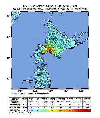
A magnitude (Mw) 6.6 earthquake struck the island of Hokkaido in northern Japan at 18:07 UTC on September 5, 2018, (03.07 JST on September 6), according to the U.S. Geological Survey (USGS). The epicenter was located at a depth of 33.4 km in the Iburi Subprefecture, about 20 km east of the coastal city of Tomakomai and 62 km southeast of Sapporo. No tsunami warning was issued. The event triggered significant landsliding causing damage to buildings and vehicles, as well as widespread power outages. Reports indicate nearly three million households without power, affecting about half of the 5.3 million residents of the Island. Media reports indicate at least sixteen fatalities and over 150 injured, with 26 others still missing. It will take time to fully assess the scope and severity of this event, and our first thoughts and concerns are with those affected.
Geological Background
The Mw 6.6 earthquake occurred at a depth of 33.4 km as the result of shallow reverse faulting. According to the United States Geological Survey (USGS), the faulting involved either a moderately dipping reverse fault striking northwest, or a shallow-to-moderately dipping fault striking southeast. The event occurred in a collisional belt in the vicinity of the Nohoro-Kyuryo fault zone. The tectonic activity in the area is driven by convergence of the Pacific, Eurasian and North American (Okhotsk) plates, with the Pacific plate shifting west-northwest at a pace of approximately 87 mm/year relative to the North American plate and subducting beneath the Eurasian plate. The earthquake is likely to have occurred as a consequence of rupture of a fault within the North American plate. During the last century, 70 earthquakes with Mw 6.0 or above have occurred within a 250 km radius of the epicenter of this event, but with only six at shallow depths. During the 36 hours following the event, the Japanese Meteorological Agency (JMA) reported nineteen aftershocks with Mw 3.0 or higher, of which two were Mw 5.0 or higher.

USGS Shakemap: Hokkaido, Japan Region. Source: USGS.
Hazard data illustrated in the GC AdvantagePoint users can view impacted areas on any map as well as see how their portfolios were affected. Please contact your broker or cat modeling analyst for further information.
Impact
At least sixteen fatalities have been reported with over 150 injured, and 26 missing according to officials of the Crisis Management Office of Hokkaido Prefecture Government. Rescue and recovery efforts are ongoing. Authorities have arranged temporary shelters on many locations in the region. The earthquake caused significant landslides, and destroyed multiple buildings in the area, including houses buried in the epicentral region, according to media reports and the USGS. Reports indicate that roads were buckled, along with some liquefaction due to shaking. Fractured water pipes have been reported causing disruption to water supply in some areas. Some disruption to telecommunications systems has also been reported.
The quake also brought damage to the Tomato Atsuma coal-fired power plant, causing automatic shut-down of the plant. The resulting imbalance in the power distribution grid triggered widespread blackouts. The 1.65 gigawatt plant covered about 50 percent of energy demand in the region and restoration efforts could take about one week, according to officials. Partial restoration is underway.
As a temporary measure, Hokkaido Electric Power Co. restarted the Number 1 unit of its Sunagawa plant. The power outage affected nearly three million buildings including more than 40 hospitals, and disrupted telephone service and television broadcasting. It also forced shops to close and firms to halt operations. Toyota Motor Co. temporarily shut down its manufacturing plant in Tomakomai.
Meanwhile Toppan Printing, Kirin Beer and Sapporo Beer also announced disruption to operations at their factories. Trading was halted at the Sapporo Securities Exchange according to reports. Media reports also indicate that the blackout disrupted the power supply to the Tomari nuclear plant, and the plant relied on emergency diesel generators for ten hours to avoid radiation incidents. The island cannot receive power from neighboring utilities because power lines between Hokkaido and Honshu were damaged during the event, according to media reports. Industrial impacts include a fire reported at a Mitsubishi Steel Manufacturing oil refinery facility in Muroran that was subdued by firefighters. Meanwhile oil distributor Idemitsu Kosan Co. announced it has temporarily suspended shipments to its refinery in Tomakomai according to media reports.
Transportation impacts include closure of the main New Chitose Airport where over 200 flights were cancelled, affecting more than 40,000 passengers, according to reports. The airport has since reopened although reported flight disruptions continue due to equipment shortages. This followed the shutdown of Kansai Airport on September 4 due to Typhoon Jebi. All train services on the Hokkaido Island were suspended, together with subway lines in Sapporo. Reports indicate that railway services are progressively being restored.
Preliminary USGS analysis indicates that several urban areas including Sapporo, Tomakomai, Ebetsu, and Chitotose were exposed to level 7 shaking on the Mercalli Modified Intensity scale (MMI), affecting about 2.4 million people. The study indicates probable significant and widespread damage. The USGS Pager Service estimates most probable economic losses between USD 100 million and USD 1 billion.
Sources: Japan Meteorological Agency, United States Geological Survey, Insurance Journal, PropertyCasualty360, Nikkei Asian Review, The Japan Times, The Mainichi Shimbun, The Telegraph.