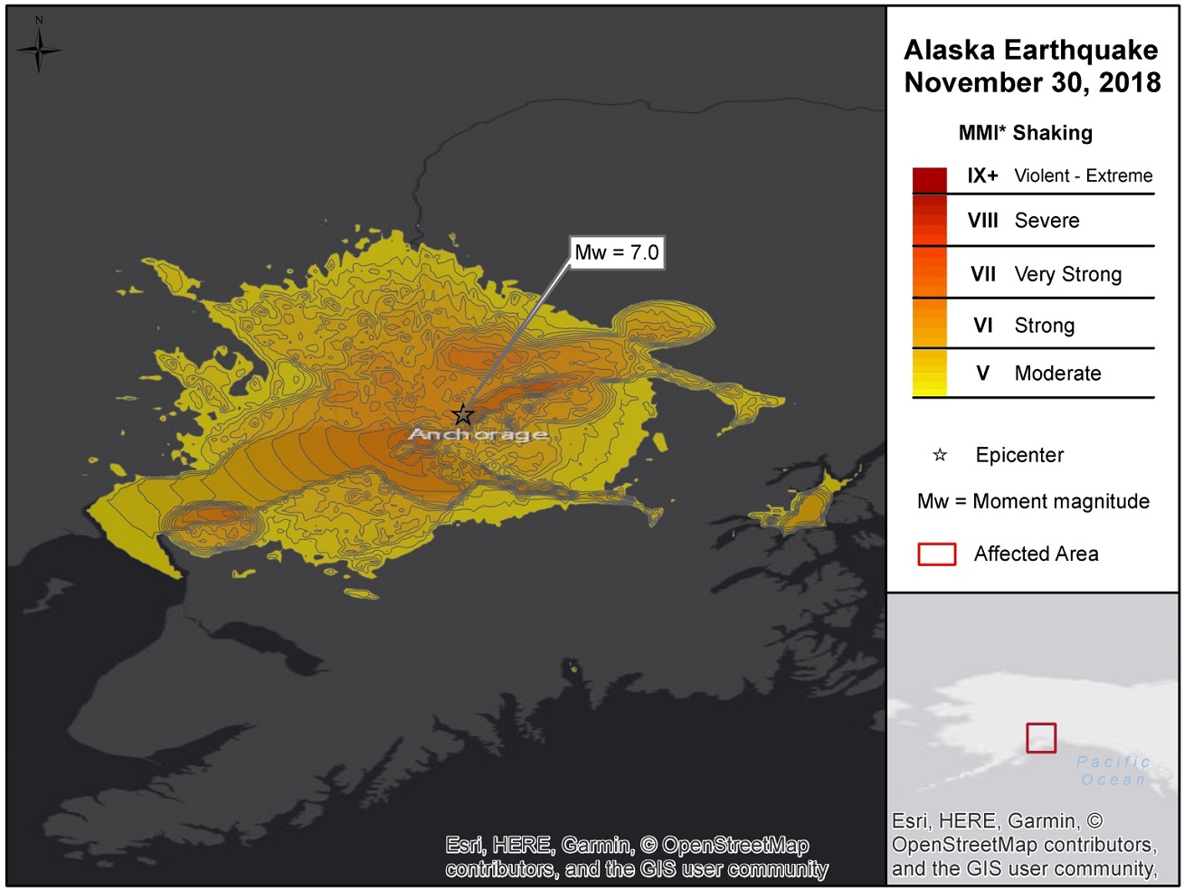
A magnitude (Mw) 7.0 earthquake was reported near Anchorage, Alaska around 17:29 UTC on November 30, 2018 (8:29 local time), according to the U.S. Geological Survey (USGS). The epicenter was located at a depth of 44.1 km and about 12.9 km (8.0 miles) north of Anchorage, Alaska. A tsunami warning was issued but later lifted by the U.S. National Weather Service. Initial media reports indicate that the event rendered considerable damage to infrastructure including roads, power and water, along with significant transportation disruption. Damage has been reported to buildings including interior damage and some cracked foundations with some building collapses. Initial media reports indicate no fatalities or injuries, although survey efforts are still ongoing.
Geological Background
The Mw 7.0 earthquake occurred at a depth of 44.1 km as the result of a slip on an intraslab fault within the subducting Pacific slab. According to the United States Geological Survey (USGS), the faulting involved a moderately dipping fault striking north-south, below the shallower thrust-faulting interface between Pacific plate and the North America plate.

Hazard data illustrated in the GC AdvantagePoint users can view impacted areas on any map as well as see how their portfolios were affected. Please contact your broker or cat modeling analyst for further information.
The Aleutian Arc extends approximately 3,000 km from the Gulf of Alaska in the east to the Kamchatka Peninsula in the west. It marks the region where the Pacific plate subducts into the mantle beneath the North America plate. East of the Aleutian arc along the Gulf of Alaska, crustal earthquakes occur as a result transmitted deformation and stress associated with the northwestward convergence of the Pacific plate that collides a block of oceanic and continental material into the North America plate. The event occurred within this collisional belt. At the location of this earthquake, the Pacific plate is moving towards the northwest with respect to the North America plate at about 57 mm/yr.
During the two hours following the event, there have been 7 aftershocks with a magnitude larger than 4.0, with the largest magnitude being a Mw 5.1 which occurred about 6 km North of the epicenter. According to a forecast by the USGS, over the next week there is a 4 percent chance of one or more aftershocks that are larger than Mw 7.0.
A tsunami warning was issued by the U.S. National Weather Service for areas of the nearby Alaskan coast including Kodiak, Seward and Homer but was later lifted.
Over the past century, 14 other Mw 6 or higher earthquakes have occurred within 150 km of the November 30, 2018 event. Two of these – a Mw 6.6 earthquake in July 1983 and a Mw 6.4 event in September 1983 – were at a similarly shallow depth and caused damage in the region of Valdez. The Mw 9.2 great Alaska earthquake of March 1964 was an interface thrust faulting earthquake that ruptured over several hundred kilometers between Anchorage and the Alaska-Aleutians trench, and to the southwest.
Impacts
Initial media reports indicate variable damage to buildings and infrastructure. Many homes and businesses have been damaged according to local officials, and foundation cracks have been reported in some buildings along with reports of building collapses. The University of Alaska Anchorage has closed its campus and urged non-essential personnel to leave; some damage has been reported on campus. Fallen ceiling tiles were reported at one Anchorage high school, and homeowners have also reported picture frames and mirrors knocked from walls. Some supermarkets have had products scattered and lighting damage. People moved outside or under desks during the quake and aftershocks, according to media reports.
There are also reports of considerable damage to infrastructure. Cracked roads have been reported, and many roads and bridges have been closed. A large section of an overpass near the Anchorage International Airport has collapsed, stranding one car near the collapsed section. The quake has also caused power outages, bringing traffic light failures and traffic disruption. Most radio stations are no longer broadcasting. Disruption to water supply has also been reported in the affected area including some ruptured water mains. Significant disruption to air travel has been reported at the Anchorage International Airport. Railway service has been suspended pending track inspection, according to media reports.
Initial media reports indicate no injuries or fatalities.
Preliminary USGS analysis indicates that Anchorage, Knik Fairview and Eagle River were exposed to level 7 shaking on the Mercalli Modified Intensity scale (MMI), affecting about 332,000 people. The USGS Pager Service estimates the most probable range of economic losses between USD 10 million and USD 1 billion.
Sources: United States Geological Survey, Associated Press, Reuters, Washington Post, BBC, U.S. National Weather Service. Guy Carpenter publishes CAT-i reports for major CAT.i@guycarp.com if you wish to be added to the free email distribution list.