
Summary
A significant flood event affected portions of the Ottawa and Saint Lawrence River Valleys and surrounding watersheds. The flooding is a result of recent snowmelt from a significant snowpack, coupled with recent periods of heavy rainfall affecting the area. Evacuations have affected over 9,500. Several thousands of homes have been inundated by the resulting floodwaters, and several thousand more are under threat in eastern Ontario and western Québec.
Hydrological/Meteorological Discussion
The flooding in large part is due to rapid snowmelt from the significant snowpack just north of these areas, coupled with heavy rainfall. Between April 18-20, 2019, a slow-moving frontal boundary with embedded areas of low pressure crossed the area, with abundant moisture. The resulting rainfall amplified the flood threat within the affected area. At Montréal International Airport (CYUL), 44.8 meters of rainfall was observed for the April 18-20 period, with 31.0 meters observed on the 19th alone. An additional 22.6 mm was observed at the airport on April 26th with a total of 32.4 meters observed between the 26th and 27th, according to Meteorological Service of Canada (MSC) records. Similar observations were found at the Ottawa International Airport (CYOW), with 46.4 meters observed between April 18-20 and 35.4 meters on the 19th alone. Another 13.4 meters of rainfall was observed on the 26th.

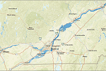
Source: JBA
Hazard data illustrated in the CAT-i map was taken from GC AdvantagePoint®, Guy Carpenter's web-based risk management platform. GC AdvantagePoint users can view impacted areas on any map as well as see how their portfolios were affected. Please contact your broker or cat modeling analyst for further information.
Media reports indicate that the Ottawa River is expected to rise 30-60 centimeters above those levels observed during the spring 2017 floods, to peak Tuesday or Wednesday after already reaching record levels. Meanwhile, the Bonnechere and Madawaska Rivers also were reported at high or record-high levels in the County of Renfrew. Additional rainfall is expected in the affected area this week.
Official forecast and gauge data can be found at https://weather.gc.ca and https://wateroffice.ec.gc.ca/ respectively.

Impacts
Media reports indicate that a state of emergency is in effect for several communities in eastern Ontario and western Québec as a result of active or potential flooding.
In the Province of Québec, evacuation orders have affected at least 9,500 compared to around 4,000 with the spring floods of 2017, according to media reports. Québec officials report at least 6,400 homes flooded and more than 3,508 isolated due to washed out roads or landslides. At least one fatality has been reported.
In the Montréal area, at least 94 residences have been flooded with another 49 isolated by flood waters. Evacuations have affected at least 55. A state of emergency remains in effect, and has been renewed for another five days. Meanwhile, around 6,000 were evacuated from Ste-Marthe-sur-le-Lac after flood control measures failed over the weekend, flooding around 2,500 homes. The Grenville-sur-la-Rouge area was also under threat where the Rouge and Ottawa Rivers meet, with threat of failure from the Bells Falls Dam; the threat prompted evacuation of 23 residences and 38 cottages. Nearly a dozen areas in the Papineauville area have also been isolated and are in immediate danger of flooding. Evacuations in Pontiac have already affected hundreds of homes. Significant flooding has also been reported in Val-des-Monts. There have been numerous reports of road closures and road damage due to floodwaters.
Meanwhile, the Canadian Armed Forces have been deployed to the Ottawa-Gatineau area to render assistance. Road and bridge closures have been necessary, including the Chaudière Bridge. In the City of Gatineau, media reports indicate at least 1,400 registered as flood victims, associated with around 575 homes. The City of Ottawa also declared a state of emergency on April 25 where at least 21 people were evacuated according to media reports.
Further west, significant flooding has also been reported in the Muskoka area including Bracebridge. Turning east, flooding has also been reported along the Saint John River in southern New Brunswick. Damage due to inundation has been reported. Water levels were reported to be at least 1 meter higher than flood level in Fredericton, according to media reports. It is too early to determine the full scope and severity of this developing event with any clarity.
Sources: CBC, Canadian Underwriter, CNN, Pelmorex, Meteorological Service of Canada, U.S. National Weather Service.
Guy Carpenter publishes CAT-i reports for major natural catastrophes worldwide. These reports cover catastrophes including worldwide tropical cyclones, earthquakes, major UK and European floods and any other natural event that is likely to incur a significant loss to the (re)insurance industry. Please email CAT.i@guycarp.com if you wish to be added to the free email distribution list.