
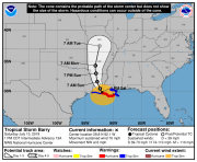
According to advisories of the National Hurricane Center (NHC), Tropical Storm Barry was upgraded to hurricane status while moving ashore about 40 miles south of Slidell, Louisiana at 11AM EDT Saturday, July 19, 2019. The storm was later downgraded by the NHC to tropical storm status as it continued to move inland. Impacts due to flooding and wind have been reported in affected areas, and significant flood impacts are expected by the NHC.
Status – 2PM EDT (18 UTC) (NHC)
- Location: About 30 miles south-southwest of Slidell, LA
- Maximum sustained winds: 70 miles per hour
- Motion: northwest at 6 miles per hour
- Minimum central pressure: 996 mb
- Status: Strong Tropical Storm (Weakening)
Landfall Status – 11AM EDT (15 UTC) (NHC)
- Location: About 40 miles south of Slidell, LA
- Maximum sustained winds: 75 miles per hour
- Motion: northwest at 6 miles per hour
- Minimum central pressure: 993 mb
- Status: Category-1 Hurricane
Discussion
- Barry has moved ashore over recent hours to the south of Slidell, Louisiana and is expected by the NHC to slowly cross through central Louisiana and into Arkansas through Monday.
- Barry briefly strengthened to hurricane status while moving ashore late this morning due to warm Gulf waters, despite wind shear, dry air, land interaction and an asymmetric structure. The storm has since been downgraded to tropical storm status as it continues to move inland.
- Regardless of status, Barry will continue to produce excessive rainfall amounts. Heavy rain bands have yet to move onshore and the slow forward motion of the storm will amplify rainfall totals. Local banding features of the storm could escalate local rainfall totals if the bands remain in place for prolonged duration.
Hazards of Concern
- Excessive rainfall to produce flooding and flash-flooding for affected areas. The slow forward motion of the storm together with local river systems already in flood stage has amplified the flood threat. Rainfall amounts as high as 10-20 inches are possible per the NHC, with some localized amounts even approaching 25 inches. Damage to property and infrastructure can be expected in affected areas due to inundation, with more substantial damage due to water velocity and waterborne debris in the most severely affected areas. The flood effects will be of prolonged duration and last well into next week.
- Coastal flood inundation due to storm surge has already been reported for affected areas of both the Gulf coast and Lake Pontchartrain. Water levels under storm surge could reach 3-6 feet above ground per the NHC. Damage can be expected due to inundation and water velocity to both property and infrastructure.
- Tropical storm winds continue to bring the threat of downed trees and powerlines along with light to moderate property damage over a widespread area. Damage will be more severe along and to the right of the track where hurricane conditions were in place for a few hours per the NHC. Tropical storm wind conditions should continue for a much broader area for a longer duration as the storm moves inland. There is also a risk for tornadoes on the eastern flank of the storm. Light to moderate wind damage has been reported in affected areas including Morgan City, Louisiana, along with downed trees and powerlines. Power outages have already affected tens of thousands according to initial media reports.
- The NHC and local National Weather Service Offices maintain hurricane, tropical storm, storm surge, flood and flash-flood watches and warnings for areas under potential or immediate threat. Specifics can be found at www.nhc.noaa.gov and www.weather.gov, respectively.
The next Sentinel statement on this feature will be published on Monday.
Official watches and warnings, and statements from emergency management agencies supersede this update, and should be closely followed concerning matters of personal safety.

NHC Position and Best Forecast. Source: NOAA/NHC.
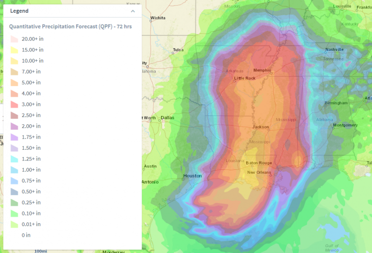
72-Hour Precipitation Forecast. Source: NOAA/WPC
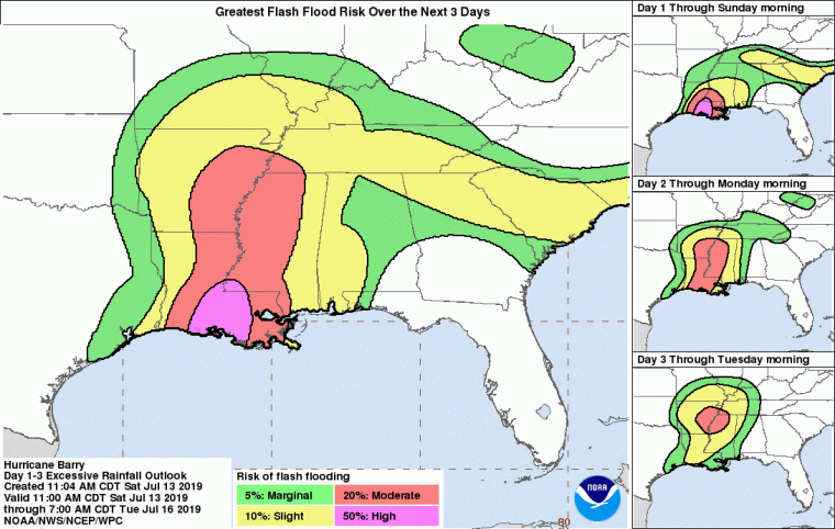
Risk of Flash Flooding – Through 8AM EDT (12 UTC) July 16. Source: NOAA/NHC