
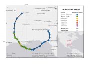
Hurricane Barry made landfall near Morgan City, Louisiana on July 13, 2019, briefly reaching hurricane status while moving ashore. The storm has since weakened and its remnants have moved into the Lower Great Lakes area. The slow forward motion of the storm has rendered widespread flooding and localized significant flooding in Louisiana, Mississippi and Arkansas. Wind impacts have also been reported, including general light property damage in affected areas with downed trees and powerlines and resulting power outages. More severe impacts have been reported near Morgan City, Louisiana and along Lake Pontchartrain. Widespread transportation disruption has also been reported, and energy assets in the Gulf of Mexico experienced considerable output reduction as a result of the storm.
Meteorological/Hydrological Discussion
Hurricane Barry originated from a mid-level disturbance during the week of July 8. As this disturbance crossed into the northern Gulf of Mexico from the Florida Panhandle, it initiated showers and thunderstorms in an environment with warm surface waters and modest wind shear. Over time the shower and thunderstorm activity was able to cluster and organize. The U.S. National Hurricane Center (NHC) initiated advisories at 11 AM EDT (15 UTC) July 10 for Potential Tropical Depression Two while the feature still lacked a closed circulation, at which time tropical storm and storm surge watches and warnings were issued for areas under threat on the northern Gulf Coast. Shower and thunderstorm activity continued to develop, cluster and organize in the meantime.
Once a closed circulation developed at 11 AM EDT July 11, the NHC reclassified the feature as Tropical Storm Barry, with maximum sustained winds of 40 mph. The storm was centered about 95 miles south-southeast of the mouth of the Mississippi River at the time. A Hurricane Watch was then issued shortly after at 2 PM EDT (18 UTC), and then a Hurricane Warning at 5 PM EDT (21 UTC) for areas under escalating threat on the northern Gulf Coast. Model guidance showed a considerable range of both track and intensity scenarios at the time, lending low confidence to the forecast. The storm then slowly strengthened over the next 24 hours due to very warm waters despite increasing wind shear, dry air, land interaction and a very asymmetric structure. The storm moved on a very slow turn from a west to a northwesterly direction in the meantime. Barry then retained status as a strong tropical storm while slowly approaching the coast.
According to NHC advisories, Barry strengthened to hurricane status while moving ashore about 40 miles south of Lafayette, Louisiana near Intracoastal City at 11 AM EDT (15 UTC) July 13. Maximum sustained winds at landfall were 75 mph, with a central pressure of 993 mb. NHC advisories noted that the strongest winds were concentrated near the eastern side of the center of circulation as the storm moved inland, with little meaningful effect on overall impacts. Barry weakened rapidly following landfall as it continued to move inland. The NHC downgraded Barry to a tropical storm at 2 PM EDT (18 UTC), and hurricane watches and warnings were downgraded by the NHC to tropical storm watches and warnings shortly after at 5 PM EDT (21 UTC). Unofficial wind gusts reported by the U.S. National Weather Service (NWS) include 72 mph at Pinto Island, Alabama, 67 mph at Cypremort Point, Louisiana and 54 mph at Hallsville, Texas. The storm also produced a considerable tornado threat. The storm surge from Barry also produced considerable coastal flooding along portions of the Louisiana Gulf Coast and Lake Pontchartrain. More severe effects were reported in Terrebonne Parish, with serious impacts also reported in Mandeville and Metairie.
Hurricane Barry Track and Position Reports. Approximate position reports prior to NHC classification are shown to show the track of the original disturbance as it left the continent over Florida. Source: NOAA/NHC.
Tropical Storm Barry maintained status as a tropical storm while moving slowly into northwest Louisiana. Barry was downgraded to a tropical depression by the NHC at 5 PM EDT (21 UTC) July 14, at which time remaining NHC tropical storm watches and warnings were cancelled. Tropical Depression Barry then slowly moved toward the Central Mississippi Valley, and was reclassified as a post-tropical cyclone (frontal system) at 5 PM EDT (21 UTC) July 15 before slowly moving into the Great Lakes by the afternoon of July 17.
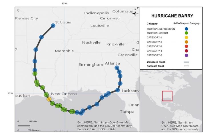
The slow forward motion of Barry allowed very heavy rainfall amounts to accumulate for affected areas. While the potential was in place to produce excessive rainfall over very widespread areas of Louisiana and Mississippi, this potential was only partially realized as the storm was disrupted due to dry air intrusion and wind shear. Nevertheless, swaths of rainfall well in excess of ten inches were found across south-central Louisiana and south-central Arkansas. Rainfall accumulations of 23.59, 18.16 and 13.30 inches were reported near Ragley, Louisiana, Oberlin, Louisiana and Pass Christian, Mississippi, respectively according to unofficial U.S. National Weather Service (NWS) reports. A rainfall total of 14.58 inches was reported near Mufreesboro, Arkansas as the storm moved slowly across the area, with 16.17 inches unofficially reported near Dierks, Arkansas. Higher rainfall totals may be reported as the NWS continues to assess observations. State rainfall amounts in Arkansas are potentially record-setting for a tropical cyclone. Additional NWS rainfall totals can be found at https://www.wpc.ncep.noaa.gov/discussions/nfdscc2.html.
7-Day Precipitation Amounts (Radar-Estimated). Ending 8 AM EDT (12 UTC) July 16. Source: NOAA/AHPS.
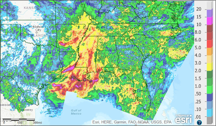
The heavy rainfall compounded the impacts of local river systems that were already in flood stage at the time of landfall, due to the effects of spring snowmelt and high seasonal precipitation amounts across large areas of the United States. This year has seen among the top-ten rainfall totals since 1895 from the Southern Plains to the Saint Lawrence Valley.
Statewide Precipitation Ranks Relative to the 1895-2019 Period. Source: NOAA/NCDC.
Impacts
Media reports indicate widespread flooding across Louisiana, Mississippi and Arkansas, with localized areas of severe flooding where high water rescues were necessary. Wind impacts include downed trees and powerlines across widespread areas of Louisiana and Mississippi, along with resulting power outages. Power outages were reported by media to affect more than 325,000 across multiple states. Light property damage due to wind was also reported, with localized moderate impacts near coastal areas. Impacts to energy interests include evacuation of hundreds of operators from platforms and rigs in the Gulf of Mexico with resulting production disruption. Nearly 70 and 56 percent of Gulf oil and gas production were respectively affected. Media reports indicate that Karen Clark & Company estimated insured losses of around USD 300 million, to include storm surge and wind impacts, but to not include losses to the National Flood Insurance Program. Media reports to date indicate no serious human injuries or fatalities as a result of Barry.
Louisiana
Widespread flooding of variable severity has been reported by media. More severe flood effects were seen in Terrebonne Parish after a levee on the Mississippi River was overtopped on Sunday, and high-water rescues were necessary as a result along with evacuation of about 400 people. A levee in Plaquemines Parish was also overtopped. Meanwhile nineteen residents were evacuated from residences threatened by floodwaters in Calcasieu Parish. Flooding in coastal Parishes resulted in over 90 people rescued in at least eleven Parishes. Transportation disruption due to flooded roadways was also reported, with water-covered streets and flooded vehicles reported in Evangeline Parish. Floodgates in the New Orleans area were all sealed for the storm.
In the meantime, there were numerous reports of downed trees and powerlines with resulting power outages. Light property damage due to wind was also reported, with more moderate damage reported near Morgan City. A state of emergency was declared by the governor.
Mississippi
In Mississippi, prolonged heavy rainfall amplified existing flood levels on large areas of the Mississippi Delta and farmland that have experienced flood impacts since February. Meanwhile in Marshall County, a possible tornado damaged part of a church roof, damaged about a dozen homes and brought down trees Tuesday afternoon; several people were treated for minor injuries. A state of emergency was declared by the governor.
Arkansas
Significant flooding was reported across widespread areas of Arkansas. Water rescues and damaged roadways were reported by media in portions of Hempstead, Howard and Nevada Counties. Flash-flood emergencies were declared in these counties as well as in portions of Pike and Clark counties. Severe vehicle inundation was reported in a parking lot in Nashville, Arkansas along with water intrusion in City Hall and the Police Department. Flooded businesses were also reported in portions of Gurdon. A portion of Interstate 30 was closed due to floodwaters according to the State Department of Transportation, along with portions of numerous other state highways including Highways 29, 51, 182, 19, 301, 67, 371, 278 and 70. The State Department of Transportation reported that the Interstate and most highways were reopening on Tuesday. No human casualties have been reported to date by media, although one animal drowned due to flooding at a humane society shelter in Clark County.
Alabama
More than 250,000 gallons of sewage spilled from systems along the Alabama coast during the storm. Regions affected include D’Olive Creek in Daphne, Fairhope, Hollinger Creek in Bay Minette, and three creeks in Mobile near Mobile Bay, according to media reports.
Sources: U.S. National Hurricane Center, U.S. National Weather Service, Reuters, Associated Press, The Weather Channel, Insurance Journal