

There is an escalating threat for hurricane landfall on the U.S. Northern Gulf Coast over the coming days from a disturbance now located offshore of the Florida Panhandle. There remains considerable uncertainty in forecast specifics, but landfall on the Louisiana or perhaps the Texas coast appears most probable given current model guidance. The threat of landfall with hurricane intensity is most likely per the U.S. National Hurricane Center (NHC), with a wide range of intensity scenarios and reduced forecast confidence. A major hurricane, while improbable, also cannot be ruled out. Interests in the area should prepare accordingly.
Forecast Overview
- The U.S. National Hurricane Center (NHC) began issuing Public Advisories for Potential Tropical Cyclone Two in the Northern Gulf today at 11 AM EDT. A tropical depression is expected to form by Thursday in the area, to potentially strengthen to a tropical storm or hurricane by Friday.
- At present, thunderstorm activity associated with this system is increasing and the storm is becoming better organized around a developing surface low. Currently, maximum sustained winds are estimated at 30 mph per the NHC. NOAA Aircraft missions will be surveying the feature later today, after which changes to the intensity and forecast should be expected.
- Storm motion is currently to the southwest, but this track is expected to gradually shift west and eventually northwest into the early part of the weekend, prior to a potential landfall along the Texas or Louisiana coastline. The intensity forecast is still highly uncertain, as there is the opportunity for strengthening over warm waters and with low wind shear.
- Hazards associated with landfall along the Gulf Coast include coastal flooding due to storm surge, inland flooding due to rainfall in excess of 12-18 inches, and winds of tropical storm or hurricane strength.
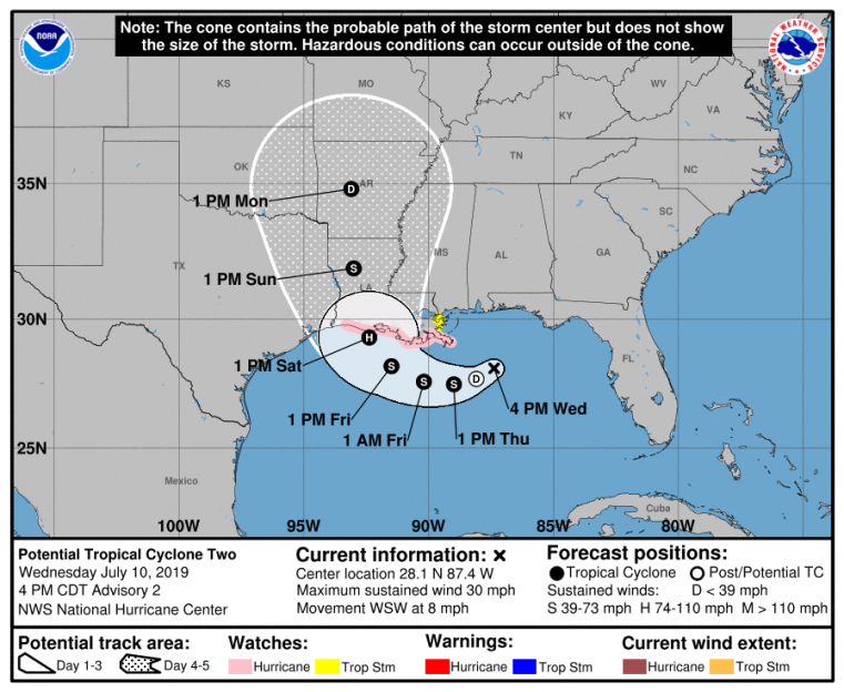
NHC Position and Best Forecast. Source: NHC
Forecast Considerations
While the NHC considers the chance of tropical storm formation to be very high – near 100 percent, there is still considerable uncertainty in terms of both track and intensity forecast. The official forecast calls for landfall on Saturday along the west-central Louisiana coastline, however the cone of uncertainty is quite wide and includes coastal areas from east Texas to New Orleans. The official track reflects the best forecast after NHC evaluation of the range of model guidance.
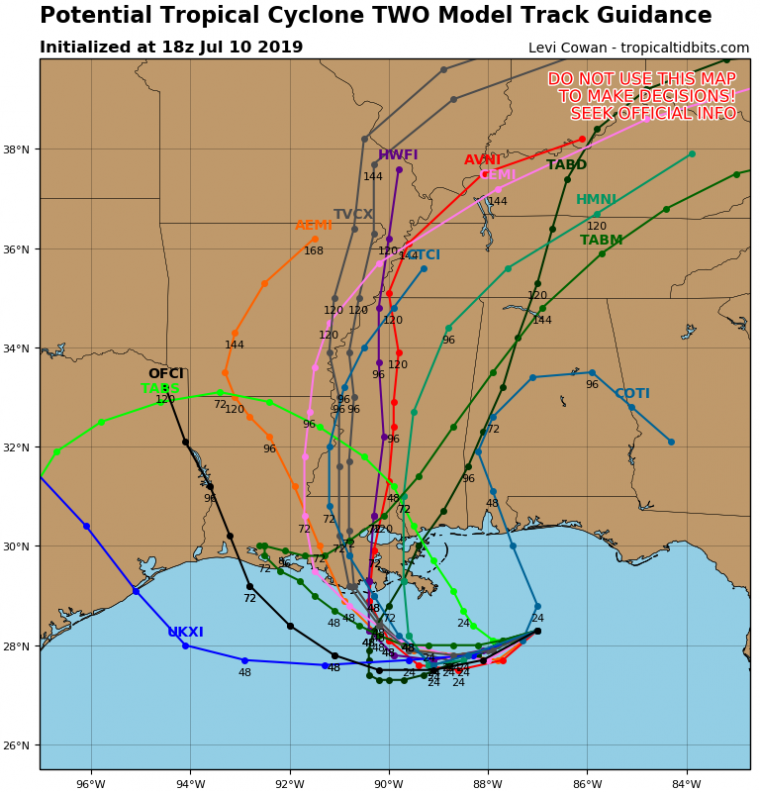
Model Track Guidance as of 18 UTC Wednesday June 10. Source: Tropical Tidbits.
The model intensity guidance also shows considerable spread, with the 18Z HWRF model intensifying the storm to Category-2 status prior to landfall, while others keep the storm at tropical storm strength. The official NHC intensity best forecast is for a strong Category-1 storm by landfall, but scenarios ranging from tropical storm to even major hurricane status cannot be ruled out, along with the possibility of rapid intensification. Intensification will be very sensitive to the track, which will affect the amount of interaction with land, underlying ocean heat content and wind shear. Aircraft reconnaissance data will better inform future model initialization, which should lead to refined track and intensity guidance with coming forecast cycles.
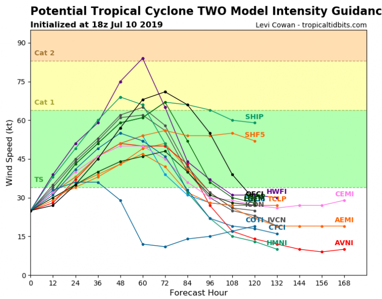
Model Intensity Guidance as of 18 UTC Wednesday June 10. Source: Tropical Tidbits.
Regardless of the exact details of landfall location and intensity, this system will generate hazardous conditions along large portions of the Gulf Coast, from Texas to Mississippi. Expectations are that this storm will produce considerable rainfall, bringing up to 18 inches of rain in some locations. Storm surge related flooding could be significant along the coast and inland along rivers and bays, with the exact level dependent on storm characteristics as well as the timing of landfall compared to the tide. Wind impacts will also be felt over a wide area as the storm moves inland.
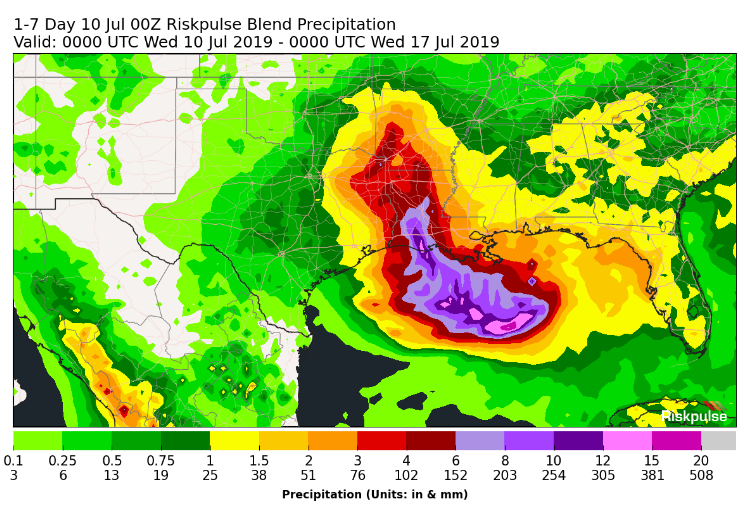
7-Day Precipitation Forecast - Ending 8PM EDT July 16. Source: Riskpulse.
Further updates will be issued as materially new information comes available. Statements from the National Hurricane Center can be found at www.nhc.noaa.gov.
Local watches and warnings from official meteorological agencies, and statements from local emergency management agencies supersede this update, and should be closely heeded concerning matters of personal safety.