
Summary
A pair of significant earthquakes struck the Searles Valley, California area (Kern County) on July 4 and 5, 2019, according to the U.S. Geological Survey (USGS). On July 4, an estimated Mw 6.4 earthquake occurred approximately 11 miles (18km) ENE from Ridgecrest (population approximately 28,000) around 10:33 AM local time. This was followed by a larger Mw 6.9 earthquake at around 8:19 PM local time on July 5, about 10 miles (17km) NNE from Ridgecrest that was initially reported as an Mw 7.1. The two earthquakes produced very strong to severe ground shaking intensities, but the most intense ground shaking was far from the larger populated areas of Los Angeles, California and Las Vegas, Nevada. Both earthquakes are considered related as they share similar seismological properties and occurred on related fault systems within the Airport Lake Fault Zone. As of July 8, the USGS was estimating a one percent chance that there will be an earthquake of Mw 7.0 or larger in the next week. Relatively little severe damage has been reported as the strongest shaking intensities did not happen in more populated areas. According to media, initial damage observations have been summarized as limited to regional infrastructure including underground pipelines and roads, and to non-structural elements in Ridgecrest.
Seismological Background
Along the Sierra Nevada mountain range in California, the Searles Valley is located within an area of known seismicity called the Eastern California shear zone. This zone has distributed faulting as a part of the North America and Pacific tectonic plate boundary, and is known for its relatively high seismic hazard. The San Andreas Fault runs along the western edge of the region and is approximately 90 miles (150 km) from the recent earthquakes. Seismologists are currently mapping the fault ruptures for the Mw 6.4 and Mw 6.9 July 4 and 5, 2019 earthquakes to confirm the exact fault systems, and have hypothesized that these earthquakes are a result of the Airport Lake Fault Zone.
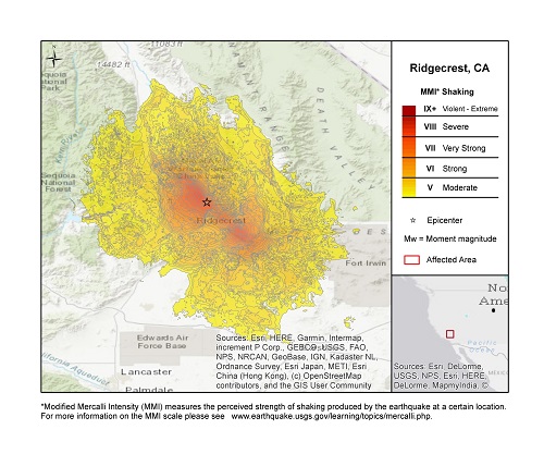
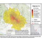
Mw 7.1 Earthquake Affecting Ridgecrest, California July 5 (local time). Source: USGS.
In the morning of July 4, 2019, an Mw 6.4 shallow strike-slip earthquake ruptured at an estimated depth of 10.7km. The earthquake produced ground shaking intensities that were felt from the Los Angeles, California metro region to Las Vegas, Nevada. The strongest ground shaking (MMM VI and VII) was felt by rural towns Ridgecrest (VII), smaller villages with populations less than 2,000 (VI), and the Naval Air Weapons Station China Lake (VI).
A larger Mw 6.9 earthquake struck the same region less than 34 hours later on July 5, 2019, producing stronger ground motions in the Searles Valley (initially reported by the USGS as a Mw 7.1). This was also a shallow strike-slip earthquake occurring approximately 7 miles (11km) away from the Mw 6.4 event with an estimated depth of 8.0km. Despite the larger earthquake, more populated areas were spared the higher ground shaking intensities and Ridgecrest was estimated to have felt MMI VII (very strong) shaking during the Mw6.9 event.
Seismic activity associated with these two larger earthquakes is expected by the USGS to continue for months and potentially years from now. The Southern California Seismic Network (SCSN) has estimated hundreds of earthquakes larger than Mw 3.0 on July 6 associated with the Searles Valley Earthquake Sequence. By Monday, July 8, the chance of a Mw 7.0+ earthquake occurring had reduced from 5 percent to 1 percent and is expected to decrease over time.
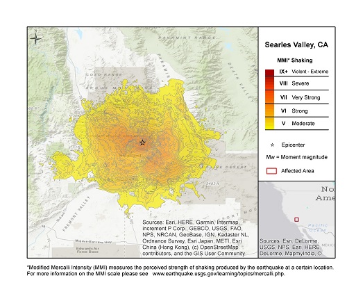
Mw 6.4 Earthquake Affecting the Searles Valley Area July 4 (local time). Source: USGS.
Impacts
Southern California had not experienced a significant earthquake since the 1994 Mw 6.7 Northridge Earthquake in the San Fernando Valley that caused significant damage to the Los Angeles metro region. The recent July 4 and 5 earthquakes 100 miles east of Los Angeles appear to have been far less impactful, according to initial media reports. The relatively low penetration rate of earthquake insurance for California homeowners (approximately 13 percent) has proved to hold for these events. California Governor Gavin Newsom has issued the highest alert for the State Office of Emergency Services and requested federal assistance. After the July 5 earthquake, estimated economic losses were projected to be around USD 100 million or more according to Governor Newsom. Meanwhile according to the USGS Pager Service, most probable loss estimates range between USD 10 million and USD 100 million, with 35 percent probability. A press release from the California Earthquake Authority (CEA) estimates claims to be limited for their estimated 2,000 policyholders in the affected region.
According to media, damage reports have been fairly limited to the areas around Ridgecrest, California. Much of the infrastructure damage (including cracked roads, ruptured pipelines and power outages) is relatively isolated and no major road closures have been reported. There were reports of two small house fires and natural gas pipeline leaks. As of July 8, all utility services and roads were restored for the Ridgecrest community.
The town of Ridgecrest has a relatively new building stock with more seismically resistant structures, and damage initially observed in the field has been to non-structural elements such as contents. Trona (population ~2,000) suffered more structural damage due to older building stock, to approximately 50 structures, with limited water service from damaged pipelines.
Sources: U.S. Geological Survey, Southern California Seismic Network, California Governor’s Office of Emergency Services, California Earthquake Authority, Reuters, Associated Press, The Los Angeles Times, Insurance Journal, FEMA