

Hurricane Dorian continued to become better organized as it moved over deep ocean heat content, and then began a slow predicted shift to the left toward Florida. The National Hurricane Center (NHC) forecast remained largely unchanged. The expectation was that large portions of the Bahamas and Florida will experience prolonged periods of hazardous weather conditions related to Hurricane Dorian, which is forecast to be category-4 as it approaches land. A developing concern was the slowing down of the system, which has implications for the magnitude of storm surge and rainfall. These aspects of the forecast, along with track and intensity considerations are discussed below.
Status (11AM EDT, 30 August, 2019)
Dorian has begun a slow westward turn overnight, in a predicted shift toward the Bahamas and Florida. Recent Hurricane Hunter flights measured category-2 winds of 110 mph, and an expansion of the extent of hurricane force winds. Dorian is moving northwest at 12 mph, located 255 miles east-southeast of the southeastern Bahamas. The NHC has issued a Hurricane Watch for northern portions of the Bahamas. The NHC best intensity forecast calls for category-4 landfall on the south central Florida coast late this weekend, with the cone of uncertainty encompassing all of the Florida coastline and reaching into southern Georgia. The onset of tropical storm force winds in Florida is expected by early Sunday, with a forecast landfall time of early Tuesday morning.

NHC Advisory 24A Indicating the addition of a Hurricane Watch for the Bahamas. Source: NHC

NHC Advisory 24 Indicating the earliest arrival time of tropical storm force winds. Source: NHC
Category 2 Hurricane Dorian Status – 11AM EDT (NHC)
- Location: 480 miles east of the northwestern Bahamas
- Maximum sustained winds: 110 mph
- Motion: northwest at 12 mph
- Minimum central pressure: 972 mb
- Extent of hurricane force winds from center: 25 miles
- Status: category-2, major hurricane (category-3 or higher) strength expected later today
Slow-Moving System Considerations
Recent forecast models and observations indicate that Hurricane Dorian will continue to intensify, while also experiencing a reduction in forward motion. Slow forward motion prolongs the amount of the time that strong winds are blowing over water, and allows storm surge to build to higher levels, especially along the coast and eventually inland. It is too early to determine where the largest surge impacts will be felt, as this is sensitive to landfall location and local coastal geography and orientation. Given the slow-moving nature of the storm, it is more likely that a high tide cycle will coincide with a period of onshore winds, thus increasing the chances of a dangerous storm surge. Additionally, heavy rainfall at landfall becomes more of a concern with systems that progress slowly, as was the case with Hurricanes Harvey and Florence of the previous two years. The Weather Prediction Center at NOAA is forecasting up to 15 inches of rain well inland and along the eventual landfall path of Hurricane Dorian, with the possibility of higher local totals.
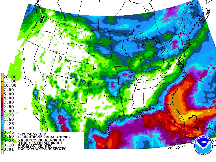
7 Day Total Accumulated Precipitation Forecast for CONUS Source: WPC/NOAA
Forecast Track Scenarios
Forecast model guidance remains in tight agreement on a slow shift to the west occurring in the next few days, bringing Hurricane Dorian in close proximity to the northern Bahamas. Currently, Hurricane Dorian is being steered between a Bermuda High and an upper level low centered over the Bahamas. These steering currents should remain well established through the next 2-3 days, however a breakdown in the Bermuda high and associated blocking ridge is expected to occur about 72 hours from now, which brings uncertainty to the steering currents that impact the motion of the storm. Forecast models are handling this breakdown in the ridge differently, with most models remaining on a course toward Florida. However, some forecast models are taking a more significant northerly track either at or slightly before a Florida landfall and tracking the storm north along the Georgia and Carolina coastlines.
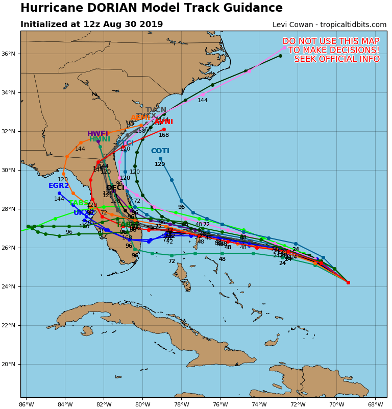
Global + Hurricane Models for Dorian, initialized 12 UTC August 30. Source: tropicaltidbits.com
The European Model is a good example of the spread in possible scenarios. The red shading below indicates confidence in the track, measured by consensus in the 51 member ensemble guidance suite of forecast tracks. Beyond 72 hours the shading trends toward blue, indicating less confidence in various track scenarios. The possibility of impacts being felt due to a northerly turn to Georgia and South Carolina is visible in yellow shading, while there is also the potential for an emergence of the system in the Gulf. Both of these scenarios raise concerns for impacts well into next week. While there is considerable spread in the modeled track forecast past 72 hours, the NHC official track remains largely unchanged from recent advisories, with a south central Florida landfall scenario the most likely.
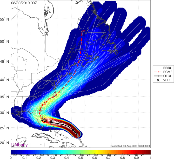
European weather model 51 member ensemble project for Dorian. The operational model of the European (dashed red line) is south of the ensemble consensus, illustrated in the warmest shaded colors. The European ensemble consensus is south of the NHC 5AM EDT forecast. Source: Dr. Brian Tang / UAlbany
Intensity Considerations
Hurricane Dorian is currently a strong category-2 storm, moving through high ocean heat content and relatively low wind shear. These ingredients are favorable for intensification of the storm prior to landfall in the Bahamas and Florida. The expectation from the NHC is that Dorian will become a major hurricane sometime during the day on Friday, and may undergo cycles of rapid intensification to category-4 as it continues a path west. Satellite imagery below illustrates a storm that continues to become better organized. Dry air intrusion and northerly wind shear over the Bahamas may cap the intensity somewhat. However, the main message remains that Dorian is becoming a large and dangerous hurricane as it moves toward a potential Florida landfall.
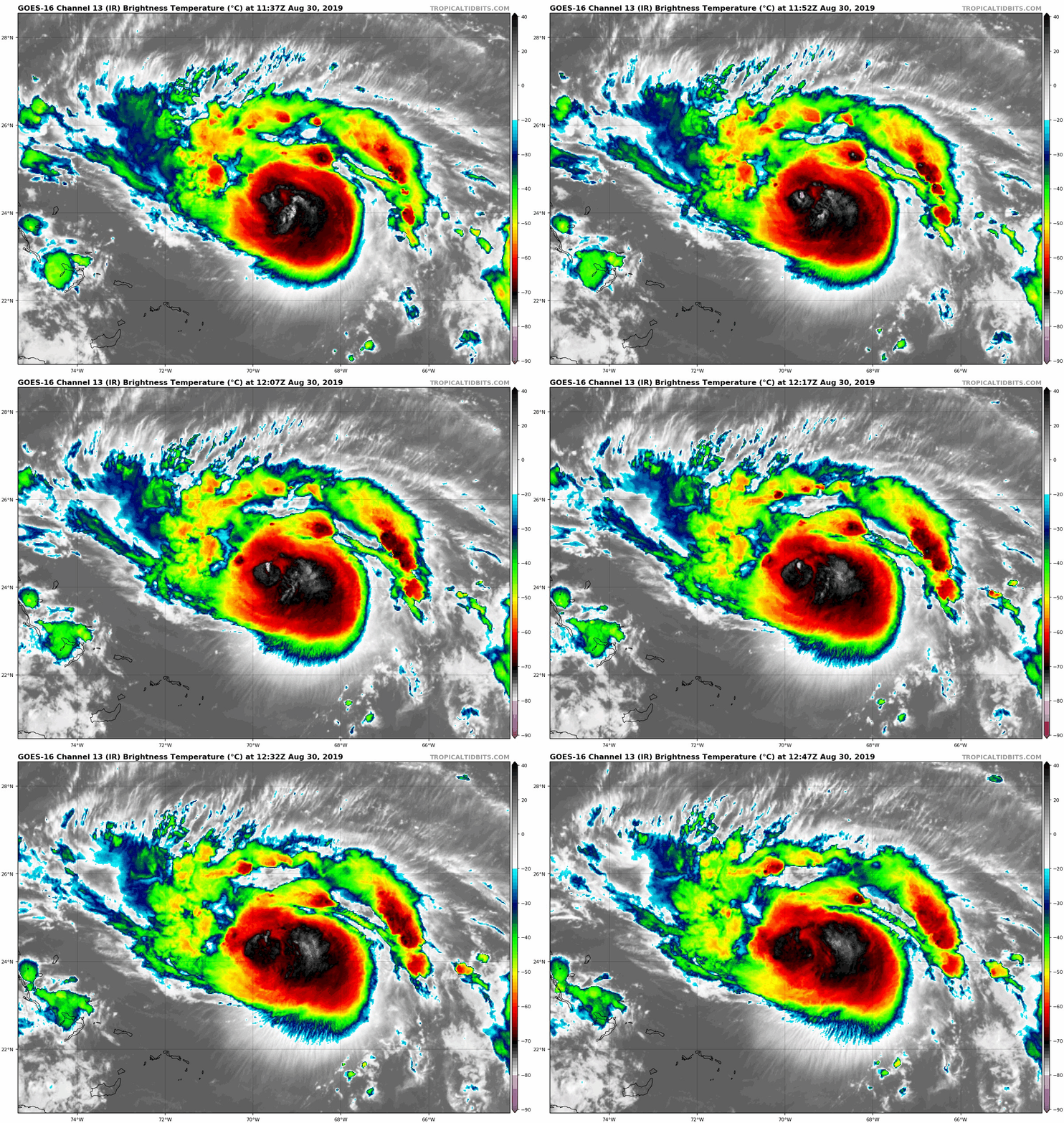
Infrared Satellite Imagery Loop for Hurricane Dorian as of 10 am EDT August 30. Source: tropicaltidbits.com
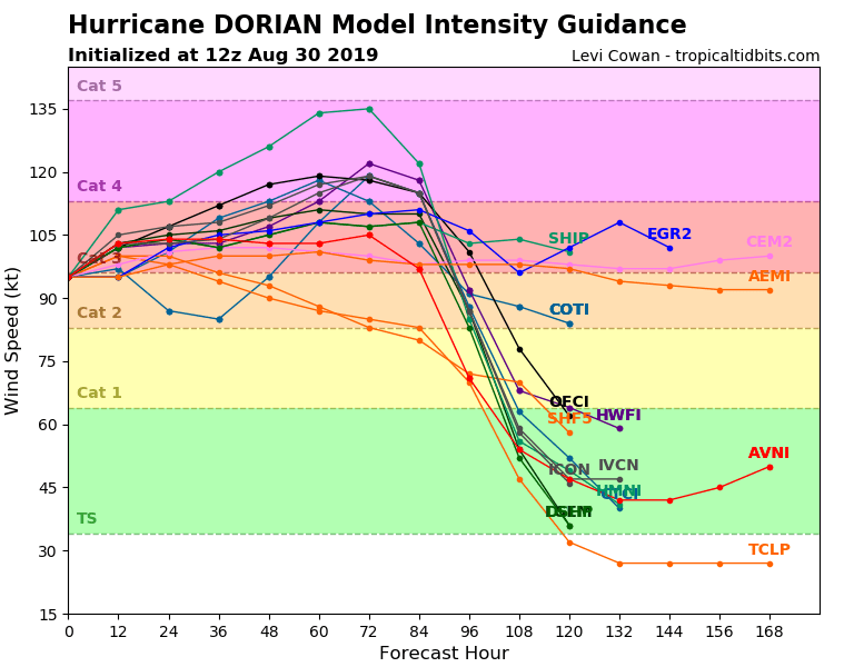
Ensemble Intensity Guidance Initialized 12Z August 30 Source: tropicaltidbits.com
Next Update
The next Weather Sentinel update was issued on Saturday, August 31, 2019. For up to date, official information, the following websites are recommended:
National Weather Service, Miami, FL
National Weather Service, Melbourne, FL
Official watches and warnings, and statements from emergency management agencies supersede this update, and should be closely followed concerning matters of personal safety.
Subscribe to Guy Carpenter Email Alerts on Real Time Activity
To receive email notifications of Weather Sentinel updates, please click on this link to update your preferences.
https://go.guycarp.com/preferencecenter
Additionally, in response to client demand, we are pleased to offer daily email alerts for any tropical cyclone occurring globally. The GC Global Tropical Cyclone Alert discusses active tropical cyclones across the globe, portraying a graphical forecast and brief commentary on intensity forecast changes expected over a 24 hour period. Fill out the form at the link below to start receiving our key insights.