

Moving into the late summer, weather patterns are favoring seasonal dryness in the western United States, where moderate to severe drought is persisting in the Pacific Northwest, and fuels are drying out and becoming receptive to fire. While fire activity has been slightly below average to date in 2019, the outlook is for normal to above normal wildland fire potential in the western United States through late summer and fall, especially in California.
Current Fire Conditions
- There are currently 18 large and uncontained fires burning in the United States, the majority of which are in the Great Basin, Northwest and Alaska.
- High pressure over the Four Corners region, along with moderate to severe drought conditions in the Pacific Northwest into Montana, has produced fuels that are receptive to fire.
- To date, the number of fires in 2019 is less than any other year in the past decade.
- To date, the acreage burned in fires in 2019 is on par with average, and is significantly less than the past two years.
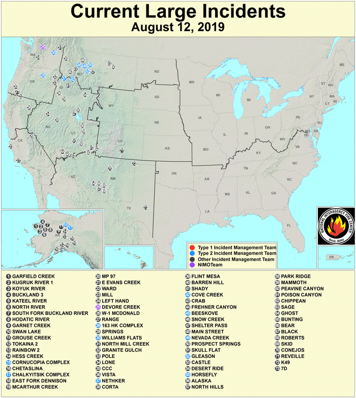
Current Large Incidents as of August 12, 2019 (National Interagency Coordination Center)
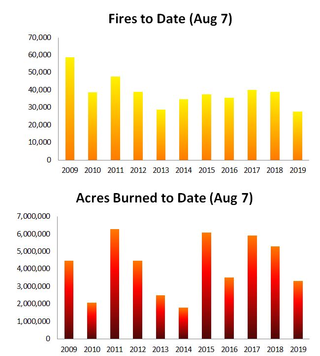
Year to Date Number of Fires and Acreage Burned as of August 8. Source: NIFC.
Drought Conditions & Forecast
- Overall drought coverage decreased in the East over the past month, with very small increases in dryness in the Northwest; less than one-half of one percent of land area is currently classified as severe drought or worse.
- Moderate to severe drought conditions exist across portions of northern Oregon, Washington, northern Idaho and western Montana.
- An area of abnormal dryness was introduced in northwest Colorado, southwest Wyoming, and far northeast Utah, where short-term precipitation deficits combined with above-normal evaporative demand over the past few months.
- Zero percent of California is rated as experiencing drought conditions. Approximately 4.0 percent of area is classified as ‘abnormally dry’.
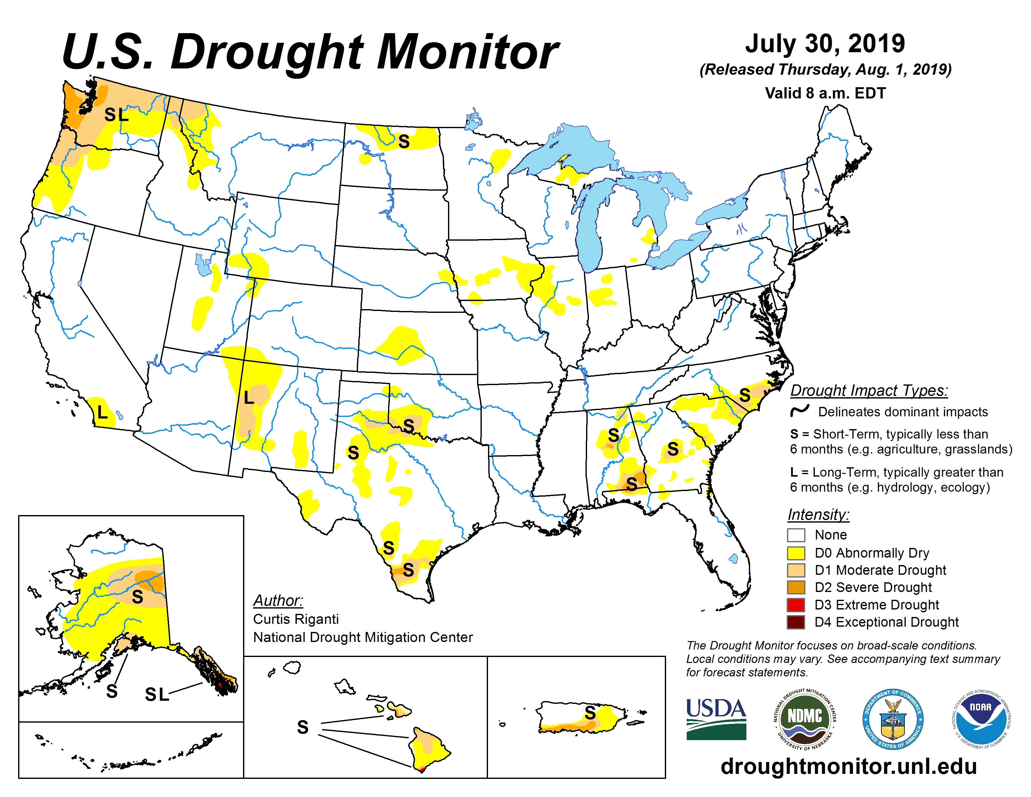
US Drought Monitor valid Aug 1, 2019. Source: NOAA.
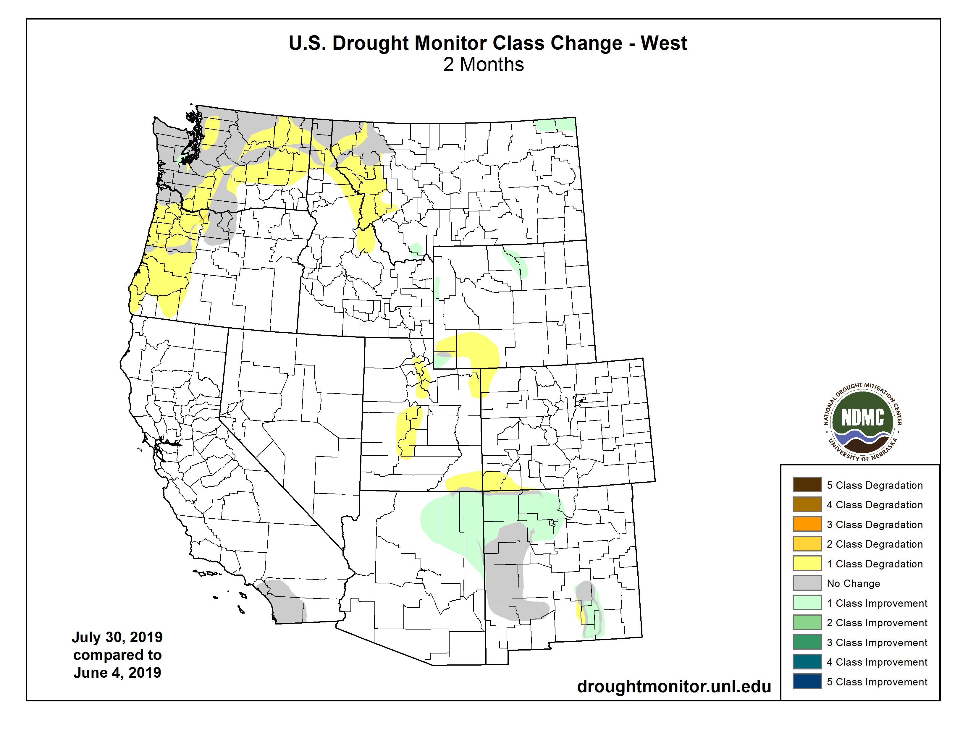 US Drought Monitor 2 month change in dryness. Source: NOAA.
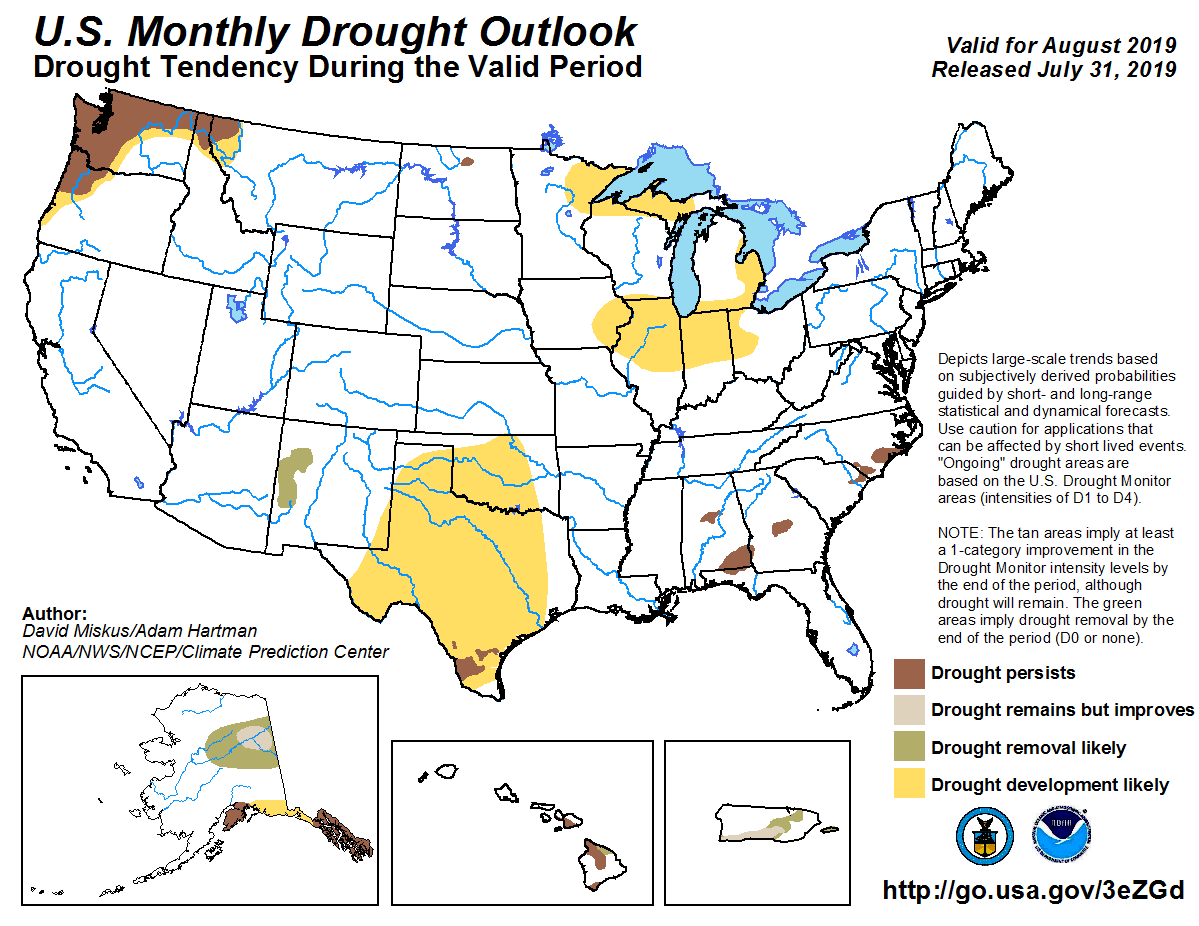
US Monthly Drought Outlook Valid August 2019. Source: NOAA.
Climatological Outlook
- The western and eastern portions of the United States are forecast to experience above average temperatures over the next three months.
- Above average precipitation is forecast for portions of the central and northern Plains for the next three months, with near average precipitation for the balance of the United States.
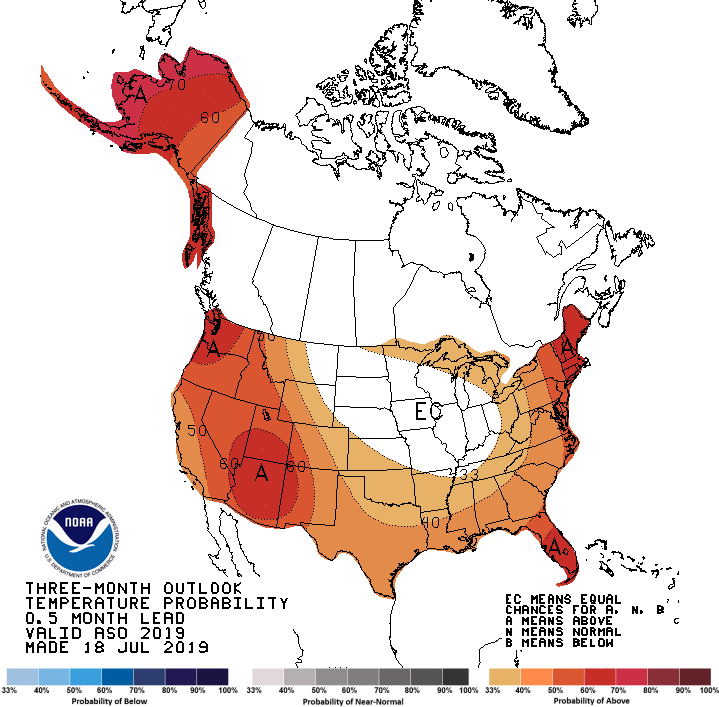
Three month temperature outlook, valid August, September, October 2019. Source: NOAA.
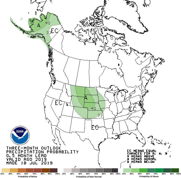
Three month precipitation outlook, valid August, September, October 2019. Source: NOAA.
Significant Wildfire Outlooks
- Fire activity was below average during July across most regions except Alaska, aided by late spring moisture and average temperatures across most of the United States.
- In late July, the Four Corners high pressure phenomenon set up, drying out fuels and leading to an increase in fire activity.
- Alaska experienced record high heat in July. Meanwhile a long duration lightning event combined with dry fuels caused above average fire activity that continues into August.
- August and September are the typical peak of the western United States fire season. Areas of concern include middle to lower elevations in California, the Great Basin and the Pacific Northwest.
- Looking forward, an active but compressed wildfire season is expected across the western United States as monsoon precipitation should arrive by the end of August and effectively put an end to the Southwest fire season.
- Lightning induced fire activity and winds may increase into late August and September as frontal passages become more common.
- While the end of September typically brings moisture and reduced fire conditions to most of the United States, California will begin to experience seasonal Santa Ana and Diablo winds, which combined with abundant fine fuels could lead to elevated fire activity into the fall.
- Parts of Alaska, Hawai'i, Washington, Oregon, California, and Nevada are forecast to have above average significant wildfire potential through September. Above average potential should be limited to Hawai'i and California beginning in October.
- It should be stressed that significant wildfires may still occur in regions forecast for normal or below normal potential.
Significant Wildland Fire Potential Outlook. Source: Predictive Services and NIFC.
Longer Term Considerations
- According to the NOAA Climate Prediction Center, recent sea-surface temperature anomalies across the equatorial Pacific Ocean and associated wind patterns indicate that the weak El Niño has transitioned to neutral conditions.
- Recent model guidance lends considerable uncertainty for the mid-autumn and winter months as model solutions diverge.
- As a result, forecast confidence in precipitation patterns, especially in California, is quite low for the fall and winter months.
This report was compiled with integrated information from the public agencies listed below. Regional conditions can vary depending on local weather conditions. Interested parties can monitor the sites below for updates and developments, and statements from these sites supersede this update.
US National Weather Service Climate Prediction Center
National Interagency Fire Center/National Interagency Coordination Center