

Tropical Storm Dorian regained structure and strength since crossing the Windward and Leeward Islands. It now appears that the storm will pass near or over the Virgin Islands over the coming hours. It is probable that the storm will strengthen to a hurricane later today. Hazards of concern include tropical storm wind conditions, heavy rainfall with some inland flooding, and storm surge.
For the longer term, Dorian poses an escalating threat for landfall on the U.S. Mainland late Sunday or early Monday, with onset of conditions sometime Saturday. Track and intensity scenarios are highly varied. The most probable scenario takes Dorian into the central Florida coast as a major hurricane. Further details below follow the 11AM EDT (15 UTC) update of the U.S. National Hurricane Center (NHC).
Status (11AM EDT/15 UTC NHC Advisory)
- Location: About 25 miles southeast of St. Croix
- Maximum sustained winds: 70 mph
- Motion: northwest at 13 miles per hour
- Minimum central pressure: 999 mb
- Status: Strong tropical storm, strengthening
Discussion
Tropical Storm Dorian was disrupted following passage of the Windward and Leeward Islands. It has since regained structure and strength and now carries status as a strong tropical storm. Dorian has also followed a more northwesterly track since yesterday.
For the immediate term, Dorian is expected to pass near or over the Virgin Islands today while strengthening to hurricane status. Hazards of concern include tropical storm or hurricane wind conditions to render downed trees and powerlines along with variable property damage. Heavy rainfall amounts of 4-8 inches and local amounts to 10 inches are also possible, to render possible flooding and flash-flooding for inland areas. Property and infrastructure may suffer a higher degree of damage given prior impacts from Hurricane Maria (2017).
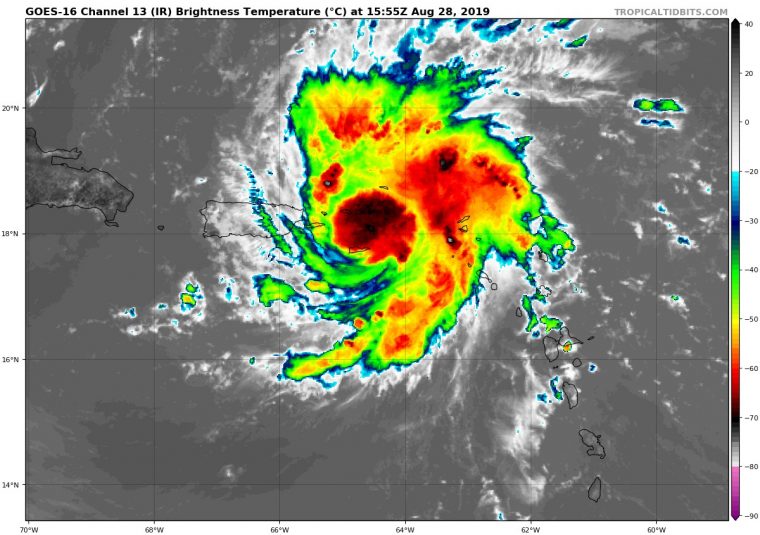
Satellite image of Dorian (infrared) ending 11:55 EDT (1555 UTC) August 28. Source: tropicaltidbits.com
For the longer term, the storm is expected by the NHC to pass east of the Bahamas through Saturday, to then approach the southeast United States Coast late Sunday into Monday. Track scenarios are highly varied and will depend on a large area of high pressure to the north, and an upper low to the south and west. The most probable scenario per the latest NHC forecast is for landfall along the central Florida Atlantic Coast into early Monday, with onset of conditions sometime late Saturday or early Sunday.
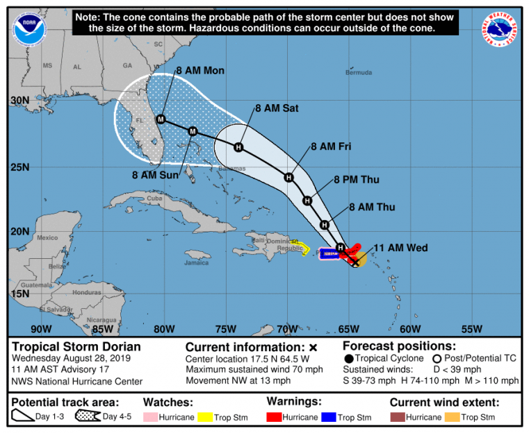
Position and Best Forecast. Source: NHC
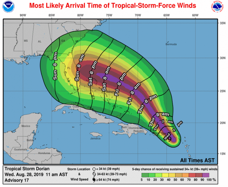
Most likely arrival time of tropical-storm-force winds and probabilities. Source: NHC
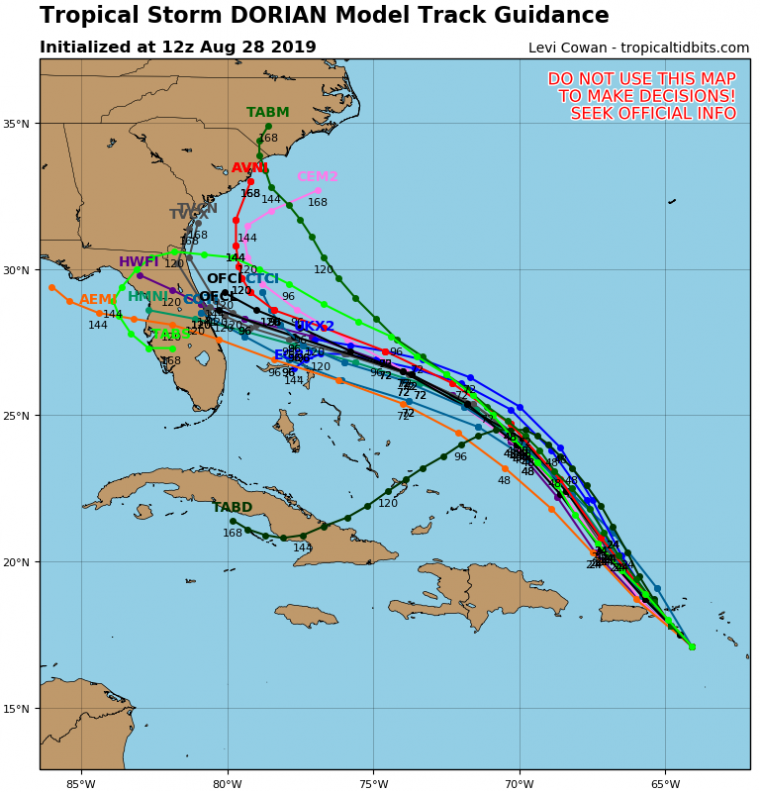
Track model guidance for Dorian. Source: tropicaltidbits.com
Concerning intensity, model guidance is highly varied. Nevertheless, Dorian will be moving over warm waters in an environment of reduced wind shear and increasing storm ventilation. Accounting for these factors and model guidance, the NHC best forecast is for landfall as a major hurricane.
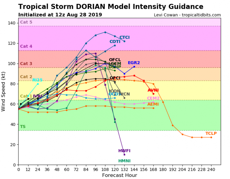
Intensity model guidance for Dorian. Source: tropicaltidbits.com
Adjustments to the forecast should be expected as conditions evolve and forecast confidence improves.
The NHC and Local Offices maintain watches and warnings for areas under potential or immediate threat. Specifics can be found at www.nhc.noaa.gov, www.weather.gov, and official government agencies. Official watches and warnings, and statements from emergency management agencies supersede this update, and should be closely followed concerning matters of personal safety.
National Weather Service, San Juan, Puerto Rico
National Weather Service, Melbourne, FL
Daily Global Tropical Cyclone Alerts
In response to client demand, we are pleased to offer daily email alerts for any tropical cyclone occurring globally. The GC Global Tropical Cyclone Alert discusses active tropical cyclones across the globe, portraying a graphical forecast and brief commentary on intensity forecast changes expected over a 24 hour period. Simply fill out the form at the link below to start receiving our key insights.