
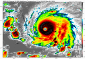
Historic category 5 Hurricane Dorian made landfall at Elbow Cay, Abacos, Bahamas with 185 mph maximum sustained winds, gusting to 220 mph. With catastrophic outcomes in the northern Bahamas, Dorian tied Wilma (2005) and Gilbert (1988) as the second strongest hurricane on record in the Atlantic since 1850. The forecast continues to be a razor's edge for Florida while coastal evacuations are now in place in Georgia and South Carolina when Dorian makes the mid-week approach to the Southeastern United States. While odds of category 1 winds are just above 50% for portions of the central/northern east coast of Florida, a slight shift west of NHC and model consensus still cannot fully rule out major category 3 sustained winds (110 mph+) on the Florida coastline. Georgia and the Carolinas should closely monitor Dorian for mid week impacts while the Mid-Atlantic may also be impacted Thursday/Friday.
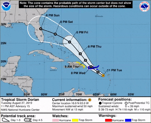
Status (8AM EDT NHC Advisory)
- Location: 120 miles east of West Palm Beach
- Maximum sustained winds: 165 mph
- Motion: west at 1 miles per hour; stalling
- Minimum central pressure: 916 mb
- Extent of hurricane-force winds: 45 miles
- Extent of tropical-storm-force winds: 140 miles
- Status: Category-5 hurricane

Evolution of Dorian Position and 3-Day Forecast, highlighting the extremely close approach to Florida. Source: NHC
Razor's Edge Forecast for Florida Stabilizing?
As highlighted in the evolution of the three day forecast above from NHC during the course of Dorian, the impacts for the Florida coastline remain exceptionally tight between little to severe impact. Hurricane warnings are now in effect from Jupiter Inlet to the Volusia/Brevard County Line, the most probable regions to experience 74 mph or higher maximum sustained winds as projected by the National Hurricane Center. The plot below highlights the five cities with the highest probabilities of experiencing hurricane force winds, as predicted by NHC, over the next 120 hours (5 days). Moreover, one can see the evolution of these probabilities for prior five day forecasts starting from Saturday morning on the right hand side of the chart. Ft. Pierce and Cocoa Beach are currently the highest probabilities of enduring hurricane force winds over the next five days. Reading the chart right to left, one can see the evolution in the forecast, from decreased threat on Saturday morning, to the higher probabilities projected yesterday with the westward shift in models. Fortunately, landfall probabilities have leveled off the past 24 hours for Ft. Pierce and Cocoa beach, and are diminishing for West Palm Beach, Daytona and Patrick AFB.
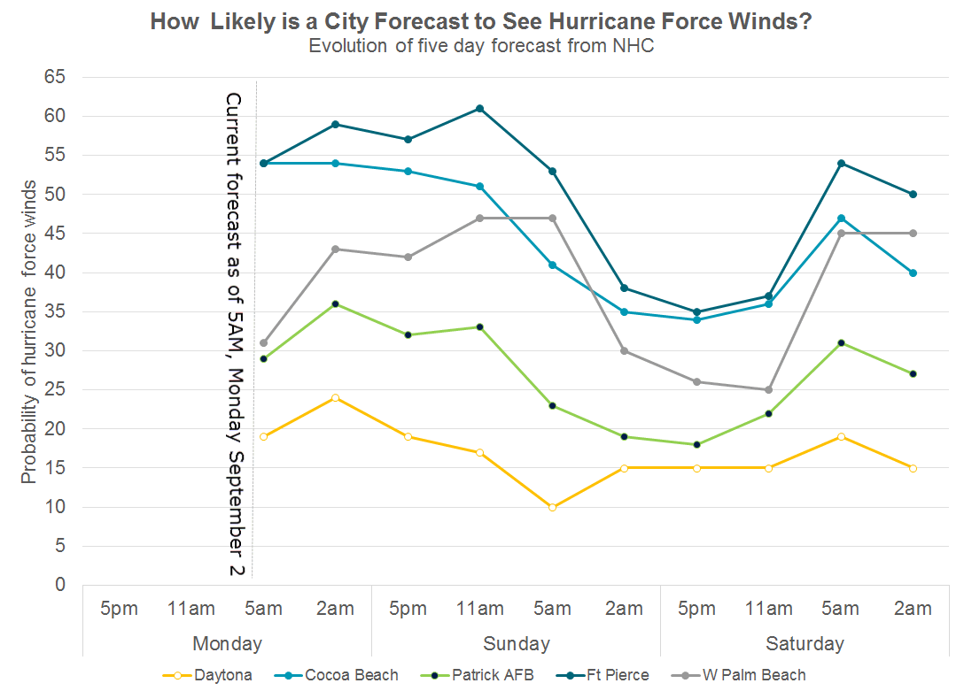
Evolution of 120 hour (5 day) cumulative probabilities of experiencing hurricane force winds. Source: NHC
One of the most sophisticated high resolution United States hurricane models, the HMON model, highlights how close hurricane force winds will be to the coast. The animation below highlights the past 6 model runs, verifying 10PM Tuesday September 3rd. The evolution of Dorian in the forecast is towards the coast, moving exceptionally close to the Florida coastline. Shadings of purple indicate a forecast of maximum sustained winds in excess of 74 mph, while pink and red in excess of category 3 gusts remain tens of miles offshore. This highlights the extreme sensitivity to any further wobbles or short term moves westward beyond the forecast, given the extremely close approach to the coastline. Any subtle changes in Dorian's real-time position in the next 24 hours will likely govern if Dorian brings more damaging winds ashore the Florida coastline. While forecasts have stabilized, any small deviations west continue to escalate risk very quickly.
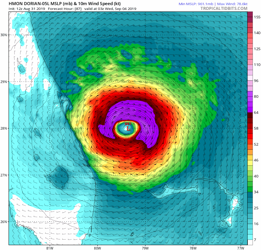
Verifying 10PM EDT Tuesday September 3, the United States HMON high resolution hurricane model is exceptionally close to hurricane force winds on the coast of central eastern Florida. Source: Tropical Tidbits
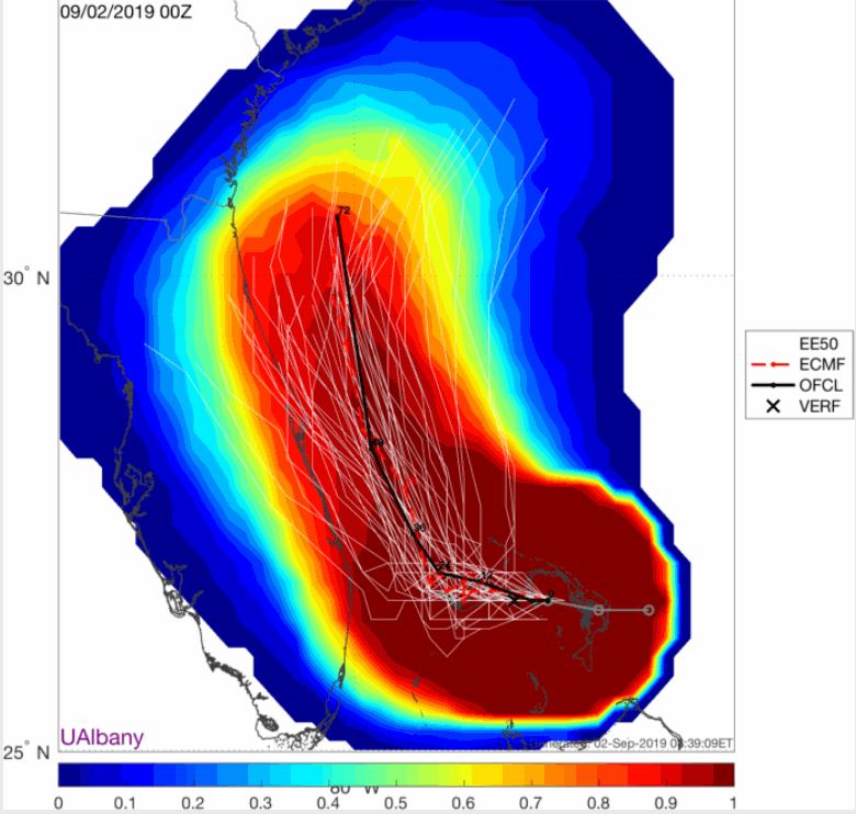
European 51 member ensemble forecast of Dorian track and hurricane force winds. The European model shifted notably west during forecasts on Saturday and early Sunday. In the last 24 hours, the model has stabilized. Shading indicates the probability of tropical storm force winds in the next 72 hours, which is in excess of 80% from Ft. Lauderdale north to the Georgia border.Source: Dr. Brian Tang, UAlbany.
Beyond Florida: Long Lived Storm Surge and Potential Wind Impacts
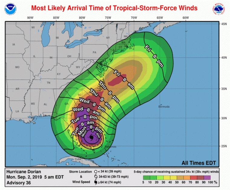
While concern remains rightly focused on the potential impacts on Florida in the short term, risk continues to escalate further north in Georgia and the Carolinas. Storm surge is already an issue in conjunction with King Tides and will rise further through mid-week as Dorian makes close approach, if not landfall, across the region. Storm surge watches and warnings are in effect for the eastern central coast of Florida to the Georgia border, with coastal flood advisories currently issued further north to Wrightsville Beach, NC. Dorian will make the turn to the north on Tuesday and is expected to be near the Florida/Georgia border by Wednesday evening. From a wind forecast, models are largely indicating the core of Dorian will be within 100 miles of the coastline. However, the windfield of Dorian will start to expand meaningfully while moving north. Thus, tropical storm force winds in coastal areas are highly likely, and hurricane force winds are still in strong consideration depending on the ultimate track of the hurricane.
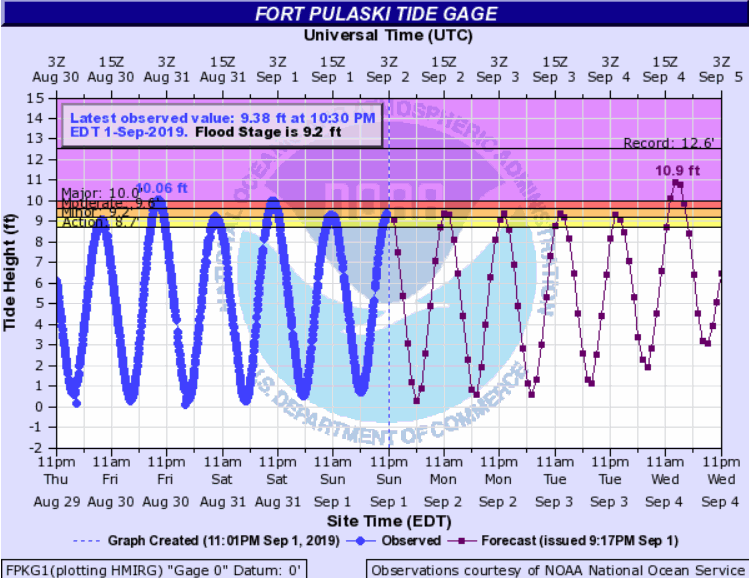
Savannah, GA forecast tides through Wednesday, September 4. With Dorian's highest storm surge anticipated on closest approach on Wednesday, the prior high tides are likely under estimated as the expanded windfield of Dorian causes continual surge into the coastline. Source: NOAA/NOS
Animation of the five day NHC forecast, highlighting the increasing risk further north along the Eastern Seaboard. Source: NHC
Further north up the United States Eastern Seaboard, interests through southern New England should continue to monitor the progress of Dorian. Tropical storm force winds are plausible in the Mid-Atlantic by Thursday and further north on Friday, depending on the ultimate track of Dorian's movement northward.
The Details of the Difficult Dorian Forecast
Simply put, the forecast for Hurricane Dorian has been an extreme challenge to this juncture. With extreme gradients of insured exposure on the edge of Dorian's path, this has doubled the challenge due to the binary nature of possible outcomes. Why has the forecast of Dorian been so challenging? Four elements have been at play, highlighted in the graphic below.
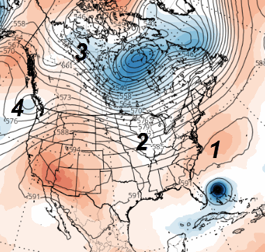
Upper atmosphere factors at play in the ultimate outcome of Dorian. Source: tropicaltidbits.com
- Bermuda High / Atlantic Ridge: Models have systematically under-forecast the intensity of the ridge over the weekend. This is the primary reason the forecasts shifted west in the last 36-48 hours closer to Florida. Why? Dorian's nearly unprecedented intensity actually helped, itself, to increase the intensity of the ridge.
- Midwest thunderstorm activity: Thunderstorm activity across the Mississippi River Valley, combined with a trough of low pressure over the Hudson Bay, has been the lead features to start to break down the Atlantic Ridge, slowing Dorian's track towards Florida.
- Northwest Canada trough: An area of upper level low pressure moved into northwest Canada yesterday. As this feature is better analyzed by weather balloons, and analyzed in weather models, this feature is the key to move Dorian more rapidly north by Tuesday/Wednesday as it moves through the northern United States. Until yesterday, this feature was not well analyzed / seen by weather models.
- Cutoff low pressure west of the Pacific Northwest: Various models, in iterations, have joined this feature with the northwest Canada trough to wreak havoc in ultimate model outcomes. It now looks that this feature will not merge with the northwest Canada trough, which would have resulted in a faster movement back towards the Atlantic.
Beyond Dorian - Atlantic Looks to Remain Active
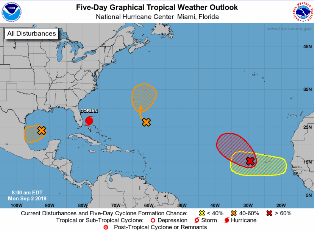
With the focus properly on Dorian the next five days, other areas of the Atlantic look to see potential storm formation this week. Most notably, a strong tropical wave departing the African coast looks to become the next named storm, although chances are high that it stays in the eastern Atlantic with no impact to land. A second disturbance southeast of Bermuda has the possibility of organizing into a tropical storm before passing close to the island mid-week. A third disturbance is also being monitored within the Gulf of Mexico that is forecast to move west towards Mexico later this week. None of these disturbances are foreseen to directly impact either the Caribbean or mainland United States.
The NHC and Local Offices maintain watches and warnings for areas under potential or immediate threat. Specifics can be found at www.nhc.noaa.gov, www.weather.gov, and official government agencies. Official watches and warnings, and statements from emergency management agencies supersede this update, and should be closely followed concerning matters of personal safety.
Next Update
The next Weather Sentinel update will be issued on Tuesday, September 3. For up to date, official information, the following websites are recommended:
National Weather Service, Melbourne, FL
National Weather Service, Jacksonville, FL
National Weather Service, Charleston, SC
National Weather Service, Newport/Morehead City, NC
South Carolina Emergency Management
North Carolina Emergency Management
Subscribe to Guy Carpenter Email Alerts on Real Time Activity
To receive email notifications of Weather Sentinel updates, please click on this link to update your preferences.
https://go.guycarp.com/preferencecenter
Additionally, in response to client demand, we are pleased to offer daily email alerts for any tropical cyclone occurring globally. The GC Global Tropical Cyclone Alert discusses active tropical cyclones across the globe, portraying a graphical forecast and brief commentary on intensity forecast changes expected over a 24 hour period. Fill out the form at the link below to start receiving our key insights.