
Hurricane Dorian began a slow northwesterly track off of Grand Bahama Island on Tuesday afternoon, September 3, 2019, on a path paralleling the Florida Atlantic coastline. Hurricane force winds are remaining offshore of Florida, however storm surge and wave action along the coastline are causing significant beach erosion and flooding. The forecast for Dorian remains extremely challenging for longer-term. Weather models are struggling to capture the complexities of the wider steering environment, with several systems (including Dorian itself) interacting with a larger trough over North America. The possibility of a landfall in the Carolinas remains uncertain, and once again, small deviations in track will cause significant differences in impacts.
Status (11AM EDT NHC Advisory)
Location: 90 miles east northeast of Daytona Beach
Maximum sustained winds: 105 mph
Motion: north northwest at 9 miles per hour
Minimum central pressure: 964 mb
Extent of hurricane-force winds: 70 miles
Extent of tropical-storm-force winds: 175 miles
Status: Category-2 hurricane
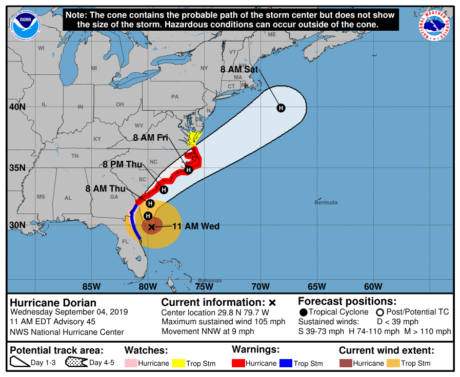
NHC 3-Day Forecast from 11 am EDT September 4, highlighting the extremely close approach to Carolinas. Source: NHC
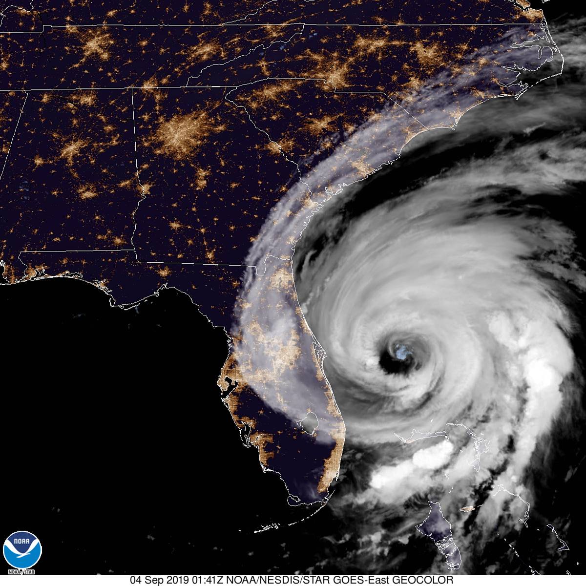
Dorian Paralleling Florida Coastline
Category-2 Hurricane Dorian has picked up speed and is now taking a nearly parallel path north along the Florida Atlantic coastline. Although the storm has lost some of it's organizational structure in response to mild shear conditions, it is maintaining deep convection, especially on the landward side of the system. This is allowing the storm to maintain category-2 status, with 105 mph sustained winds. Although it has weakened, the storm has continued to expand. Hurricane force winds extend 70 miles from the center, with tropical storm force winds extending 175 miles. Despite this expansion of the wind field, hurricane force winds have remained offshore of Florida, with tropical storm force winds extending only a short distance inland. Power outages have been reported, but appear to be fairly limited in scope. Heavy rain bands continue to affect the state, with northern counties experiencing strong wind gusts and dangerous waves and surf.
Satellite Brightness Temperature Animation for 24 hours for Dorian, highlighting the increasing strength on the western side of the storm. Source: CIMSS
Increasing Strength and Closer Passage Mean Greater Impacts for Carolinas
While Florida has appeared to escape the worst impacts from Dorian, the forecast for the Carolinas remains extremely challenging. From an intensity perspective, the environment remains supportive of maintaining current strength for at least the next 24 hours. Ocean waters in the Gulf Stream are very warm, while shear remains low. The track forecast has more complexities, as the various global and hurricane models are struggling to handle the larger scale environmental features that are steering the system. For the past 24 hours, many of the models have gradually begun shifting the track toward the Carolinas coast, with some models even predicting landfall. The NHC official forecast has remained on the eastern side of model consensus, bringing Dorian on a very close track along the coast, but avoiding a direct landfall.
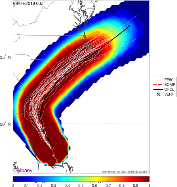
European Model 51-member suite product 00 UTC Wednesday September 4, illustrating the possibility of a Carolina landfall. Source: U of Albany
The European Model, which is historically one of the most accurate hurricane models, keeps Dorian just offshore of the Carolinas. However, two high-resolution United States hurricane models, the HWRF and HMON, both indicate landfall in the Charleston area sometime in the late Thursday / early Friday time frame. Just as models were struggling with the timing of the turn north off of the Bahamas, models are now struggling with the timing of a turn toward the northeast, which will determine whether Dorian skims the coastline, or makes a landfall somewhere in the Carolinas. The official forecast keeps Dorian offshore, but with a passage that is close enough to bring hurricane force winds, excessive rainfall and damaging surge and waves to large portions of the coastline.

HWRF Model 15 UTC Thursday September 5 (left), HMON Model 00 UTC Friday September 6 (right). Source: Tropical Tidbits
Dorian Potential Impacts in Georgia and Carolinas
Dorian will bring significant impacts to the Carolinas, as the NHC official track brings the storm extremely close to the coastline along the South Carolina, North Carolina coast. The South Carolina coastline is currently under a Hurricane Warning. Hurricane-force wind speed probabilities from the NHC indicate a roughly 30-40% chance of Charleston experiencing hurricane force winds within the next 60 hours.
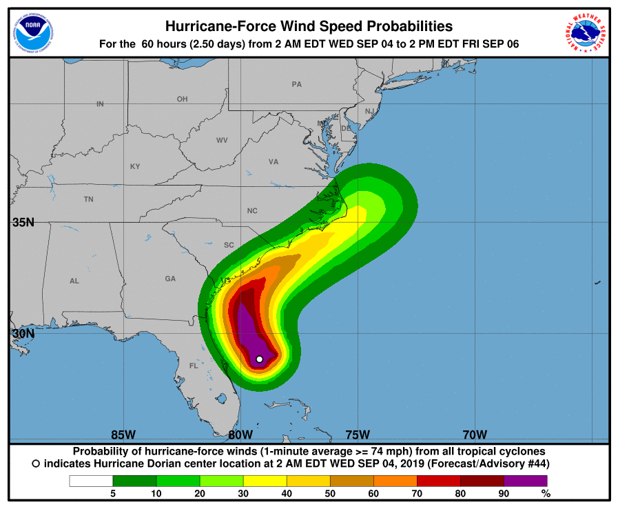
Probability of hurricane-force winds. 60 Hours from 2AM EDT September 4. Source: NHC.
A dangerous storm surge is expected, as Dorian will pass extremely close to the coastline. The size of the storm allows for a significant build-up of water, which will then be pushed by onshore winds into the inlets and bays of the Carolinas coastline. Significant wave action is also expected, with wave heights in excess of 30 feet predicted in open waters to the right of the path of Dorian. The open coastline will be subject to waves in the 10-15 foot range, while surge can travel into inland waterways a fairly significant distance, pushed by the winds and funneled into complex coastline geographies. In spot locations from Savannah to Myrtle Beach, inundation levels up to 9 feet could be experienced.
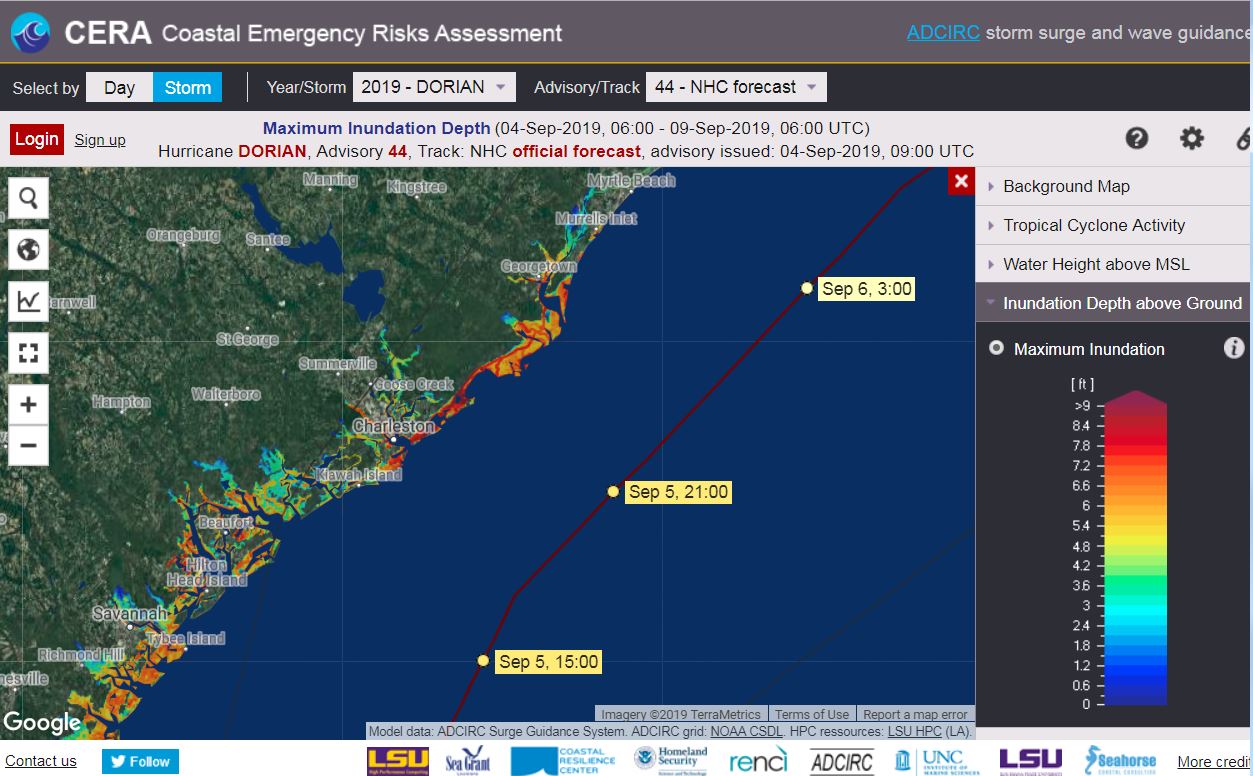
ADCIRC Maximum Inundation Forecast valid through Sept 9, based on NHC official track and intensity. Source: CERA
Along the coast, rainfall in excess of 10-15 inches is expected. Coastal rainfall, combined with storm surge, could create significant flooding scenarios. Flash-flooding is also a possibility, along with a risk of possible tornadoes accompanying the rain bands that will be moving onshore during the passage of Dorian.
Hurricane Dorian 72 hour rainfall forecast. Source: NOAA/NWS
Beyond Dorian - Peak Hurricane Season in the Atlantic Basin
Mid-September is typically the peak of the Atlantic Hurricane season, and this season is characteristically active. Tropical Storm Ferdinand is currently moving inland in Northern Mexico, while Tropical Storm Gabrielle is slowly strengthening off the coast of Africa. Additionally, there are two disturbances that have roughly a 50-60% chance of formation into tropical storms within the next 5 days; one just east of Bermuda, and one exiting the coast of Africa. The forecast does not call for impacts the Caribbean or United States at this time.
Satellite Image (Infrared) of the Atlantic Basin. Source: Tropical Tidbits
The NHC and Local Offices maintain watches and warnings for areas under potential or immediate threat. Specifics can be found at www.nhc.noaa.gov, www.weather.gov, and official government agencies. Official watches and warnings, and statements from emergency management agencies supersede this update, and should be closely followed concerning matters of personal safety.
Next Update
The next Weather Sentinel update will be issued tomorrow. For up to date, official information, the following websites are recommended:
- Local information on Dorian: Melbourne, FL, Jacksonville, FL, Charleston, SC, Columbia, SC, Wilmington, NC, Raleigh, NC, Newport/Morehead City, NC, Wakefield, VA
South Carolina Emergency Management
North Carolina Emergency Management
Subscribe to Guy Carpenter Email Alerts on Real Time Activity
To receive email notifications of Weather Sentinel updates, please click on this link to update your preferences.
https://go.guycarp.com/preferencecenter
Additionally, in response to client demand, we are pleased to offer daily email alerts for any tropical cyclone occurring globally. The GC Global Tropical Cyclone Alert discusses active tropical cyclones across the globe, portraying a graphical forecast and brief commentary on intensity forecast changes expected over a 24 hour period. Fill out the form at the link below to start receiving our key insights.