
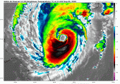
Dorian regained major category 3 strength overnight as it tracked perilously close, if not over, the coast of the Carolinas on Thursday, September 5, 2019. If Dorian retains this strength to the coast, it will be the first category 3 hurricane to make landfall in the Carolinas since Fran in 1996. Peak perils of risk that carry high certainty include dangerous storm surge, heavy rainfall inducing inland flooding, tornadoes with rain bands, and sustained hurricane force winds in coastal regions of South and North Carolina.
Status (5AM EDT NHC Advisory, Thursday September 5)
Location: 80 miles south-southeast of Charleston, SC
Maximum sustained winds: 115 mph
Motion: north at 7 miles per hour
Minimum central pressure: 957 mb
Extent of hurricane-force winds: 60 miles from center
Extent of tropical-storm-force winds: 195 miles
Status: Category-3 hurricane, slight weakening over next 24 hours
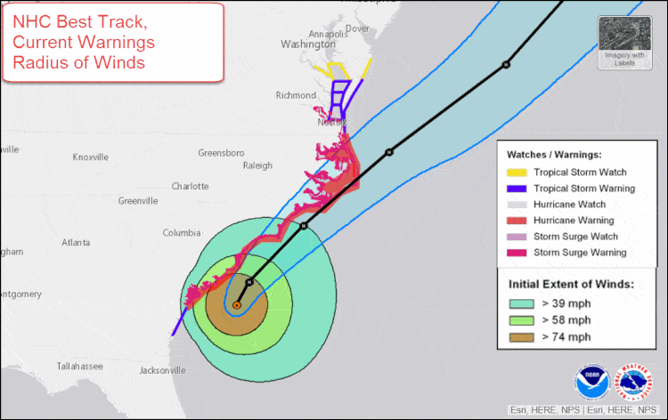
NHC best track forecast, extent of tropical storm and hurricane force sustained winds, coastal watches and warning, timing of tropical storm winds. Source: NHC
Peak Hazards
Tornado: Dorian brings a host of hazards to the Carolinas over the next 36 hours. As outer rain bands are moving onshore, a multitude of tornado warnings have been issued, with tornadoes sighted on the ground in North Myrtle Beach as well as several in southern North Carolina. This is not uncommon with landfalling hurricanes, with the majority of the tornadoes being relatively short lived, and typically at EF-0 or EF-1 intensity.
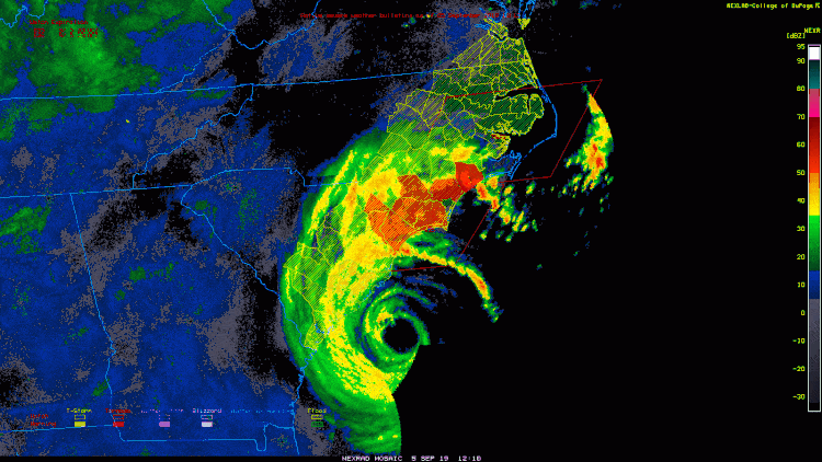
Animation of Dorian closing in on the Carolinas. Tornado warnings are highlighted in red associated with outer rain bands moving onshore. Source: weather.cod.edu
Inland Rainfall & Winds: Heavy rainfall in excess of 12", accompanied by hurricane force winds, are projected to stay relatively close to the coastline of the Carolinas. The latest rainfall and wind forecast from the overnight European model is highlighted below, courtesy of Riskpulse.
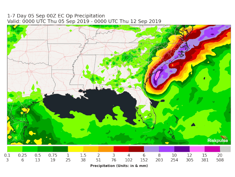
Animation of the European model projections of rainfall totals and peak wind gusts over the next seven days as Dorian traverses the Eastern Seaboard of the U.S. Source: Riskpulse
Storm surge: The forecast of Dorian's windfield expansion has verified. As a result, Dorian's large circulation will bring storm surge inundation of up to 3-6 feet, with isolated higher heights due to coastline configuration, across South Carolina northward into the southern Chesapeake Bay region.
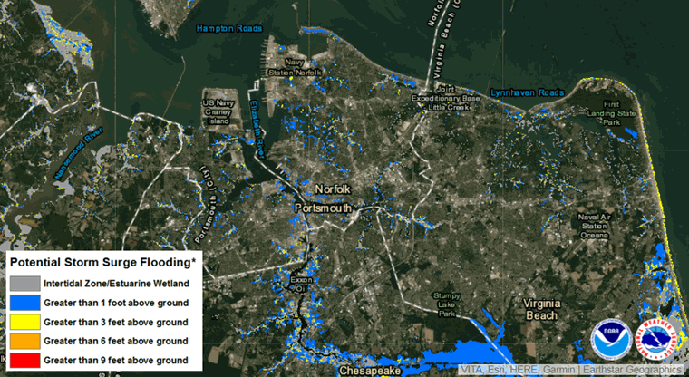
Animation of various coastal areas, illustrating the 10% probability of storm surge levels exceeding the levels indicated. Source: NHC
Dorian's Intensification towards the North Carolina Coast
Dorian tracked parallel to the Florida coastline through last night, riding along the Gulf Stream. During this process, Dorian gained further fuel to intensify back to a major category 3 hurricane, while expanding the windfield considerably, evident by the eye which is now 30 miles wide.
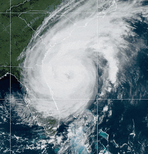
Hurricane Dorian intensifying late Wednesday September 4 over the Gulf Stream. Note the discoloration of waters surrounding the northern Bahamas due to the damage caused by Dorian. Source: NOAA
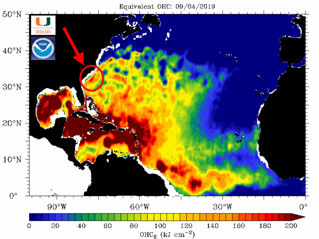
Hurricane Dorian intensified overnight while traversing a pocket of very high ocean heat content (deep, anomalously warm sea surface temperatures) over the Gulf Stream south of South Carolina. This region is highlighted in the red circle and arrow. Source: NOAA/RSMAS/UMiami
Current Industry Impacts from Dorian
Dorian has disrupted commerce in Florida and along the southeastern U.S. due to the close proximity of Dorian to landfall.
- Power Outages: The Guikema Research Group at the University of Michigan/Ohio State University projects real-time power outage forecasts based on the track of landfalling hurricanes in the U.S. Forecasts are available HERE. The current estimate of power outages based on the latest NHC forecast is 1.5 to 2.2 million customers, equating to 4.7 million people. The latest forecast is slightly lower than yesterday afternoon's outlook, provided below. The Department of Energy has also activated their 2019 Hurricane Hub, providing real-time power outage statistics, available HERE.

Power outage forecast for Hurricane Dorian as of Wednesday afternoon, September 4. Source: The Guikema Research Group, University of Michigan, The Ohio State University
- Rail/Port Operations: Dorian is causing meaningful disruptions at seaports and adjoining intermodal rail operations in the Southeastern U.S. Data courtesy of Riskpulse indicates that Norfolk Southern Rail has suspended operations into Charleston and Savannah through at least Friday September 6, while CSX Railroad has indicated delayed shipments into/out of Florida through today and the Southeast through at least tomorrow. The Port of Savannah is the single largest container terminal in North America, handing nearly 40% of U.S. poultry exports. Charleston is the eighth largest port in the U.S. by cargo volume.
- Agriculture: With Dorian not making landfall in Florida, minimal impact is expected to feedlot, fruit/vegetable acreage, or citrus operations in the state. In the Southeast, corn, soybean, poultry and hog impacts could be meaningful in the coastal areas of Georgia, South Carolina, North Carolina and Virginia.
- Trucking/Road Operations: Riskpulse estimates that 5% of all U.S. truck loads are in the path of Dorian and being disrupted. Over 500 miles of I-95 has been impacted by Dorian, with contraflow in evacuation zones halting road shipments into the most heavily impacted areas.
- Air travel: Multiple airports in Florida were closed during Dorian's approach, which are reopening today. This includes Orlando, Palm Beach, Daytona, Melbourne, Vero Beach, Pompano and Jacksonville airports.
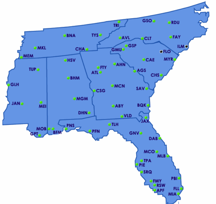
Current airport closures and delays in the southeastern U.S. Florence, SC and Wilmington, NC are currently closed for operations. Source: FAA
The NHC and Local Offices maintain watches and warnings for areas under potential or immediate threat. Specifics can be found at www.nhc.noaa.gov, www.weather.gov, and official government agencies. Official watches and warnings, and statements from emergency management agencies supersede this update, and should be closely followed concerning matters of personal safety.
Next Update
The next Weather Sentinel update will be issued Friday, September 6. For up to date, official information, the following websites are recommended:
- Local information on Dorian: Charleston, SC, Columbia, SC, Wilmington, NC, Raleigh, NC, Newport/Morehead City, NC, Wakefield, VA,Baltimore/Washington