

Early Monday morning, September 9, 2019, (3AM local time), Typhoon Faxai made landfall with maximum sustained 1-minute winds of 105 mph, a minimum central pressure of 955 mb in Chiba prefecture of the Kanto region of Japan, just east of Tokyo. An equivalent category 2 hurricane on the Saffir-Simpson scale, Chiba is one of the stronger typhoons to hit Tokyo in recorded history.
The eye of Typhoon Faxai crossed over Tokyo Bay while traversing the Chiba Prefecture in the Kanto Region early in the morning of September 9, at 3:00AM in Japan.
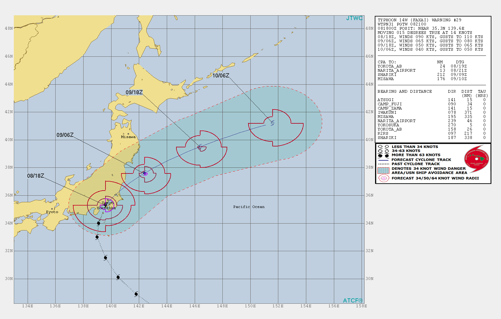
The progression of Typhoon Faxai and forecast from the Joint Typhoon Warning Center as of 18Z Sunday, September 8. Source: Joint Typhoon Warning Center

Visible satellite image of Typhoon Faxai over the Kanto Region of Japan. Source: NOAA/Himawari Satellite
Peak wind gusts
Multiple weather stations in the Tokyo region recorded all-time record high peak wind gusts as Faxai made landfall.
- 156 km/h (97 mph) at Tokyo Haneda (10 minute sustained winds of 107 km/h or 66 mph)
- 165 km/h (106 mph) at Tokyo Narita
- 207 km/h (128 mph) in Chibo

Windfield of Typhoon Faxai approaching the Japan coastline, south of Tokyo, Sunday evening September 8. Source: earth.nullschool.net
Faxai in historical context
While weather records are not complete in Japan dating back into the middle part of the 20th century, by some measures Faxai rivals the strongest typhoons to ever impact Tokyo. From a central pressure standpoint, Typhoon Violet (1961), Ida (1958), Kirogi (2000), Wipha (2013) and Lan (2017) all had stronger central pressure than Faxai. However, all three typhoons that transpired since 2000 all had 10-minute maximum sustained winds of 35 m/s (70 knots, 80 mph). Faxai at landfall recorded 10-minute sustained winds of 40 m/s (80 knots, 92 mph). Adjusted for 1-minute sustained winds, the common measure in the Atlantic Basin, the Joint Typhoon Warning Center estimated 1-minute maximum sustained winds of 105 mph. Part of the reason for Faxai maintaining atypically strong intensity towards central Japan is due to the well above average sea surface temperatures in the western Pacific.
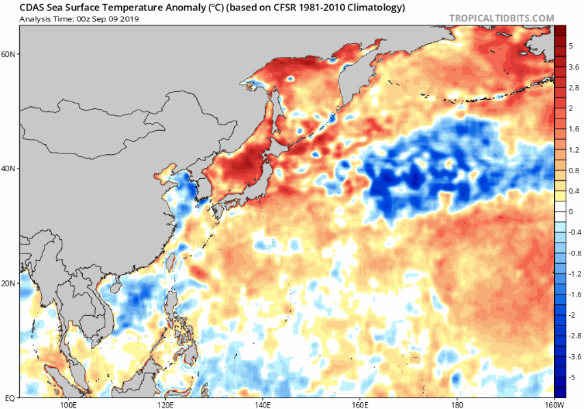
Sea surface temperature anomalies across the Western Pacific. Source: tropicaltidbits.com
Rainfall, Storm Surge and Inland Flood
Faxai was moving relatively quickly, at nearly 16 mph forward speed while tracking across Japan. Widespread rainfall totals of 100-200 mm (4-8 inches) were recorded in the Kanto region of Japan, with isolated totals approaching 250 mm (10 inches). Due to the fact that Faxai made landfall directly over Tokyo Bay, the right side of the eyewall did not funnel significant surge directly into Tokyo. Had Faxai made landfall 10-20 kilometers further west, storm surge into Tokyo Bay would have been meaningfully worse.
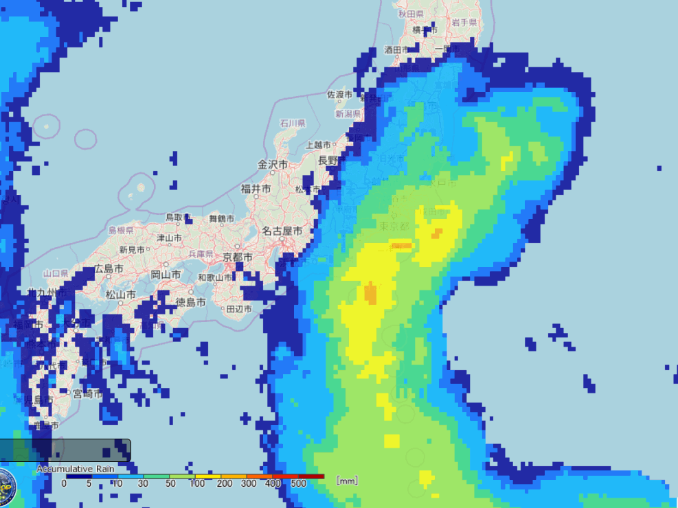
72 hour rainfall totals associated with Typhoon Faxai. Source: JAXA