

Hurricane Dorian continued to move along the coast of the Carolinas over the last 24 hours, bringing heavy rainfall, storm surge and tropical storm to hurricane conditions for eastern portions of the Carolinas. Considerable tornado activity was also reported, with substantial damage to certain areas evident from initial media reports. Landfall occurred this morning as a category-1 hurricane over Cape Hatteras, North Carolina. Dorian continues on a northeasterly track with an ongoing threat for portions of the Carolinas and Mid-Atlantic that should diminish later today. Dorian should approach Atlantic Canada for tomorrow as a strong extratropical cyclone (frontal system) with equivalent-hurricane force winds, storm surge and heavy rainfall.
Further details below follow the 11AM EDT (15 UTC) update of the National Hurricane Center (NHC).
Status (11AM EDT/15 UTC NHC Advisory)
- Location: About 50 miles northeast of Cape Hatteras, North Carolina
- Maximum sustained winds: 90 mph
- Motion: northeast at 17 mph
- Minimum central pressure: 957 mb
- Extent of hurricane-force winds: 45 miles
- Extent of tropical-storm-force winds: 220 miles
- Status: Strong category-1 hurricane
Landfall Status (8:35AM EDT/1235 UTC August 6)
- Location: Cape Hatteras, North Carolina
- Maximum sustained winds: 90 mph
- Motion: northeast at 14 mph
- Minimum central pressure: 956 mb
- Extent of hurricane-force winds: 45 miles
- Extent of tropical-storm-force winds: 220 miles
- Status: Strong category-1 hurricane
Discussion
According to statements of the NHC, Hurricane Dorian made landfall over Cape Hatteras, North Carolina around 8:35 EDT (1235 UTC) today. Maximum sustained winds at the time were 90 mph, a strong category-1 on the Saffir-Simpson Scale. Portions of the Outer Banks were affected by the western eyewall for a considerable time prior to landfall, and recent radar imagery indicates that the core of Dorian is finally pulling away from the Outer Banks area. Dorian remains a very large storm, and heavy rainfall and tropical storm to hurricane conditions remain a threat for portions of North Carolina and the Mid-Atlantic as Dorian begins to move away from the area.
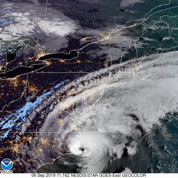
Satellite image of Dorian (geocolor) ending 11:21 EDT (1521 UTC) September 6. Source: NOAA/NESDIS
Dorian is expected by the NHC to continue on a northeasterly track, with an increase in forward speed over the coming days. This track will take it away from the Outer Banks and on a track towards Atlantic Canada. As Dorian moves away from the Gulf Stream and over cooler waters, it should undergo extratropical transition causing expansion of the wind field and development of a more asymmetric structure, with a gradual reduction of strength along the way. Dorian should cross Nova Scotia during the day Saturday before crossing Newfoundland early Sunday. Hurricane and tropical storm watches are now active per the Canadian Hurricane Centre. Tropical storm conditions may affect portions of coastal New England in the meantime and a tropical storm warning is active for portions of extreme southeastern Massachusetts.

Position and Best Forecast. Source: NHC
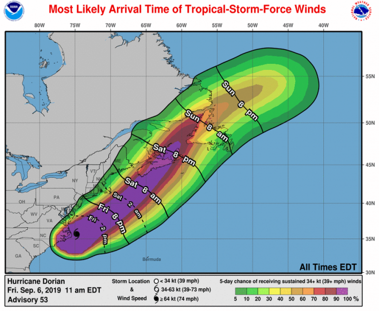
Most likely arrival time of tropical-storm-force winds and probabilities. Source: NHC
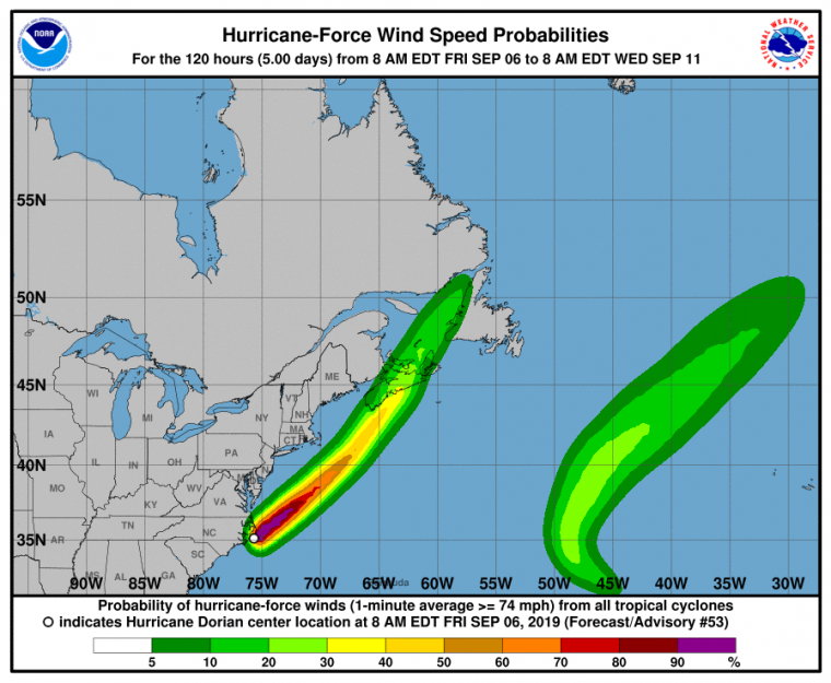
Probability of hurricane-force winds. Source: NHC
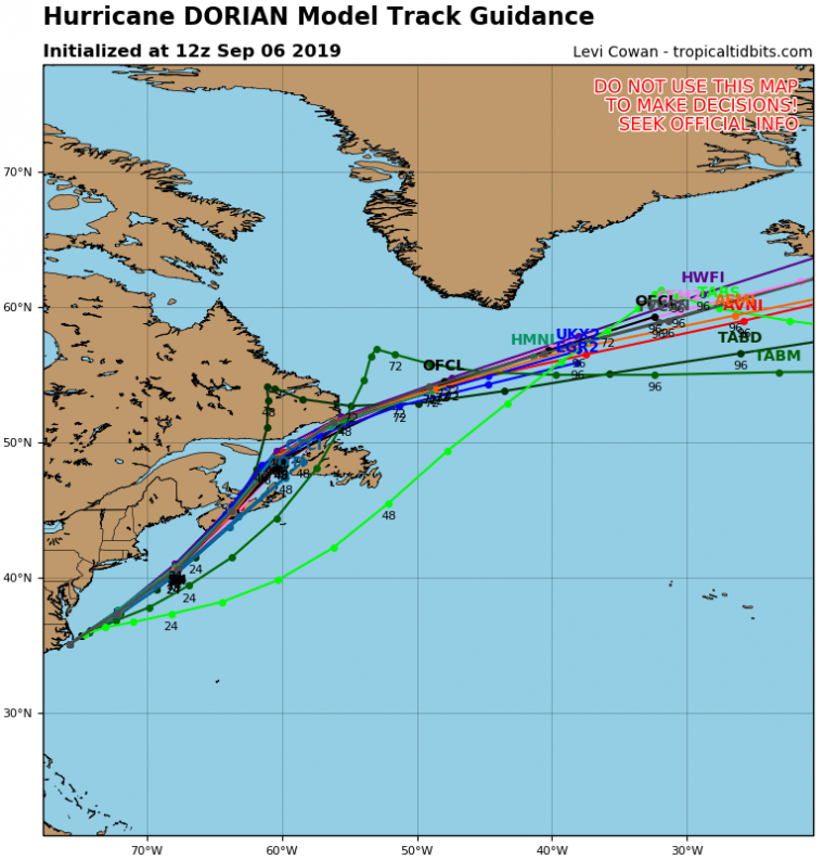
Track model guidance for Dorian. Source: tropicaltidbits.com
Hazards of Concern
Storm surge remains an ongoing threat due to persistent onshore to parallel flow and the increasing size of the storm, although the peak storm surge appears to have missed the local tidal maxima for affected areas. The peak storm surge even appears to have timed more closely with the tidal minimum for areas such as Charleston, South Carolina. Unofficial, approximate surge levels evident from NOAA National Ocean Service Gauges are on the order of 5.5 feet at Fort Pulaski, Georgia and 4.4 feet at Charleston, South Carolina. Some damage is still evident from media reports due to inundation, wave battering and beach erosion along some coastal areas and connected waterways. Flooded roadways have been reported by media for portions of Pamlico Sound. Storm surge remains an ongoing threat as Dorian clears the Carolinas and Mid-Atlantic today. Inundation heights of 4-7 feet above ground level remain possible over the coming hours from Salter Path to Duck, North Carolina including the Pamlico and Albemarle Sounds as well as the Neuse and Pamlico Rivers. Inundation heights of 2-4 feet remain possible along areas from Duck, North Carolina to Poquoson, Virginia per the NHC. The threat of storm surge will affect Atlantic Canada into the weekend.
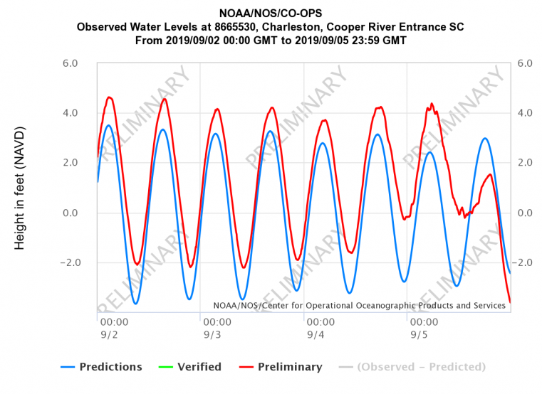
Observed Water Levels at Charleston, SC Cooper River Entrance. Source: NOAA/NOS.
In the meantime sustained hurricane-force winds have been reported at Cape Lookout, North Carolina while it was inside the western eyewall of the storm. Recent wind gusts include 96 mph in Cedar Island, North Carolina, 89 mph in Ocracoke, North Carolina and 66 mph in Cape Hatteras. Other wind gusts include 76 mph at Winyah Bay, South Carolina, 69 mph at Charleston International Airport and 67 mph at Hilton head Airport as reported by the U.S. National Weather Service. Downed trees and powerlines have been reported in numerous coastal and near-coastal areas.
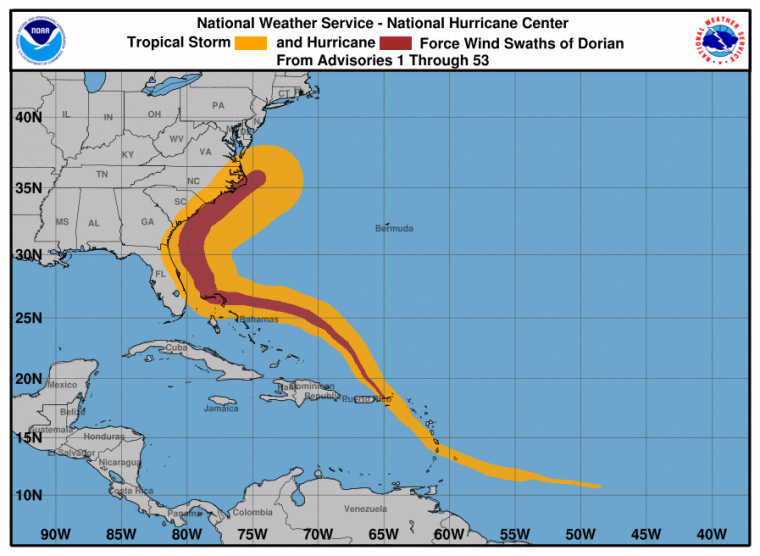
Wind History of Tropical Storm and Hurricane-Force Winds. Source: NOAA/NHC.
Meanwhile the threat of hurricane winds continues for portions of the North Carolina coast over the next few hours. Tropical storm conditions are spreading onto the Virginia coast and remain possible in the Mid-Atlantic region through the day today. Tropical storm conditions are possible over extreme southeastern Massachusetts tonight, with hurricane conditions expected over portions of Atlantic Canada Saturday. Downed trees and powerlines with resulting power outages remain possible along with some light property damage. More extensive damage to property and infrastructure remains possible for areas near the core of the storm.
Some tornado activity also remains possible over portions of North Carolina and the Mid-Atlantic today and can inflict a higher degree of damage to affected structures. Considerable tornado activity has been reported over portions of eastern North Carolina as feeder bands crossed the area over the last 24 hours. In particular, substantial property damage has been reported in Emerald Isle, North Carolina due to a recent tornado. Damage to roof and wall materials and complete damage to manufactured homes are evident from initial media reports from the area. Tornado damage has also been reported by the NOAA Storm Prediction Center and media in Carolina Shores, North Myrtle beach, Little River and northeast of Wilmington, North Carolina as well as near Little River, South Carolina. National Weather Service damage assessment teams will survey affected sites to confirm and rate tornado activity, but will likely be delayed due their primary responsibility for issuing watches and warnings for ongoing hazards.
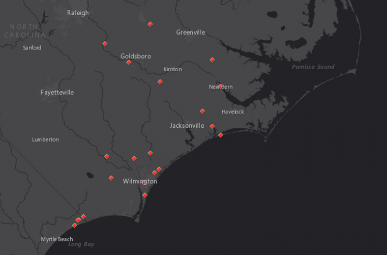
Tornado Local Storm Reports. Source: NOAA/SPC, Guy Carpenter
Heavy rainfall has been observed in the Carolinas since yesterday, with 9.92 inches reported at Wilmington International Airport and 8.87 inches reported at Myrtle Beach International Airport. Localized flooding and flash-flooding has been reported for portions of Wilmington as well as Sampson, Duplin and Washington Counties. Flooding has generally been of lesser severity as compared to Hurricane Florence (due to the increasing forward speed of Dorian). Residual heavy rainfall amounts will continue to affect portions of North Carolina and Virginia today, and then Atlantic Canada and portions of the New England Atlantic Coast into the weekend. The Canadian Hurricane Centre notes expected rainfall amounts of up to 150 mm in their advisories, and isolated amounts of 200 mm or more are possible. Flooding and flash-flooding will remain an ongoing threat in the meantime.
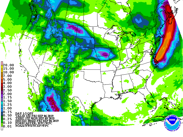
Forecast 3-Day Rainfall Accumulations Ending 8AM EDT Monday. Source: NOAA/WPC.
Preliminary observations of wind and rainfall from Hurricane Dorian can be found at the U.S. Weather Prediction Center.
The NHC and Local Offices as well as the Canadian Hurricane Centre maintain watches and warnings for areas under potential or immediate threat. Specifics can be found at www.nhc.noaa.gov, www.weather.gov, and weather.gc.ca/hurricane. Official watches and warnings, and statements from emergency management agencies supersede this update, and should be closely followed concerning matters of personal safety.
Next Update
This will be the final Weather Sentinel update on Hurricane Dorian. A GC CAT-i Report will be issued early next week to discuss the impacts of Dorian in more detail, including the catastrophic impacts that are apparent in the Bahamas; this report will be available on the CAT Resource Center of GC Capital Ideas.
For up to date, official information the following websites are recommended:
National Weather Service, Charleston, SC
National Weather Service, Newport/Morehead City, NC
National Weather Service, Wakefield, VA
South Carolina Emergency Management
North Carolina Emergency Management
Subscribe to Guy Carpenter Email Alerts on Real Time Activity To receive email notifications of Weather Sentinel updates, please click on this link to update your preferences.
https://go.guycarp.com/preferencecenter
Additionally, in response to client demand, we are pleased to offer daily email alerts for any tropical cyclone occurring globally. The GC Global Tropical Cyclone Alert discusses active tropical cyclones across the globe, portraying a graphical forecast and brief commentary on intensity forecast changes expected over a 24 hour period. Fill out the form at the link below to start receiving our key insights.