
Hurricane Dorian has rendered exceptionally severe impacts to portions of the northwestern Bahamas over the last 36 hours. In the meantime the storm has since weakened to a strong category-2 hurricane, and has developed a slow northwesterly motion in recent hours. The National Hurricane Center (NHC) best forecast takes Dorian parallel and offshore of the Florida Atlantic coast through tomorrow. Dorian should then turn to the north and east to threaten the Carolinas through Friday morning, where a direct landfall still remains very possible. The size of Dorian and resulting wind field are also expending in the meantime. Regardless of the exact track, impacts can be expected from the Florida Peninsula to the Carolinas over the coming days due to storm surge, tropical storm to hurricane winds and heavy rainfall threats. Further details below follow the 2PM EDT (18 UTC) update of the NHC.
Status (2PM EDT/18 UTC NHC Advisory)
- Location: About 105 miles east of Fort Pierce, Florida
- Maximum sustained winds: 110 mph
- Motion: northwest at 5 miles per hour
- Minimum central pressure: 959 mb
- Extent of hurricane-force winds: 60 miles
- Extent of tropical-storm-force winds: 175 miles
- Status: Strong category-2 hurricane
Discussion
Hurricane Dorian has weakened to a strong category-2 hurricane as it begins to crawl away from the northwestern Bahamas. Dorian essentially stalled yesterday for an extended period due to a collapse in surrounding steering currents between adjacent weather systems. In the meantime, the combined effect of upwelling cooler waters and dry air ingestion has eroded both the structure and strength of the storm. This is evident in the apparent degradation of the westward flank and core of the storm and considerably reduced strength in the last 24 hours.
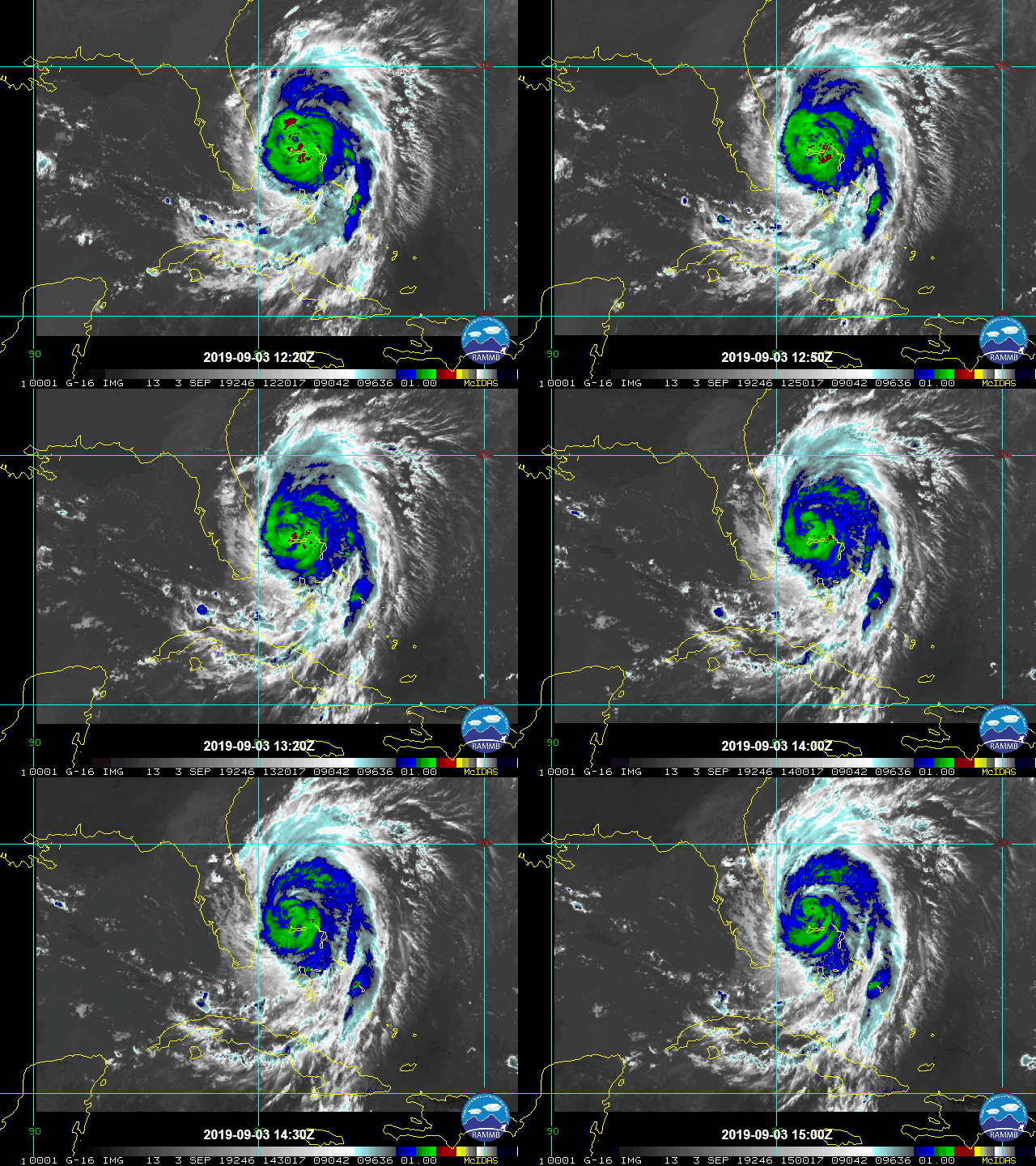
Satellite Image Loop of Dorian (Infrared) Ending 11AM EDT (15 UTC) September 3. Note degrading structure. Source: NOAA/NESDIS
It is apparent from initial media reports that Dorian has rendered catastrophic effects to portions of the northwestern Bahamas including Grand Bahama and Abaco Island. Storm surge levels of 17-23 feet and wave battering will have rendered complete damage to affected structures and infrastructure in near-coastal areas. In the meantime prolonged duration of exposure to severe category-5 winds has also brought significant damage to property and infrastructure, with many structures suffering damage to roof and wall materials. As the most severely impacted areas become accessible in coming days the full scope and severity of impacts should become more apparent. Our thoughts and concerns are with those directly affected by this event.
Dorian has since developed a slow northwesterly motion that should continue during the day. As a frontal system clears the United States mainland, the resulting steering currents should take Dorian on a turn to the north and then northeast late Wednesday into Thursday morning, with an increase in forward speed. Model track guidance is in very close agreement, lending much higher confidence in the track as compared to recent days. Accounting for these factors, the NHC best forecast takes Dorian on a track offshore of the Florida Atlantic Coast before approaching the Carolinas on Thursday. Dorian should then pass near or over the Carolinas late Thursday into Friday, where a direct landfall is still a very real possibility. After clearing the Carolinas, Dorian should move toward Atlantic Canada by early Sunday.
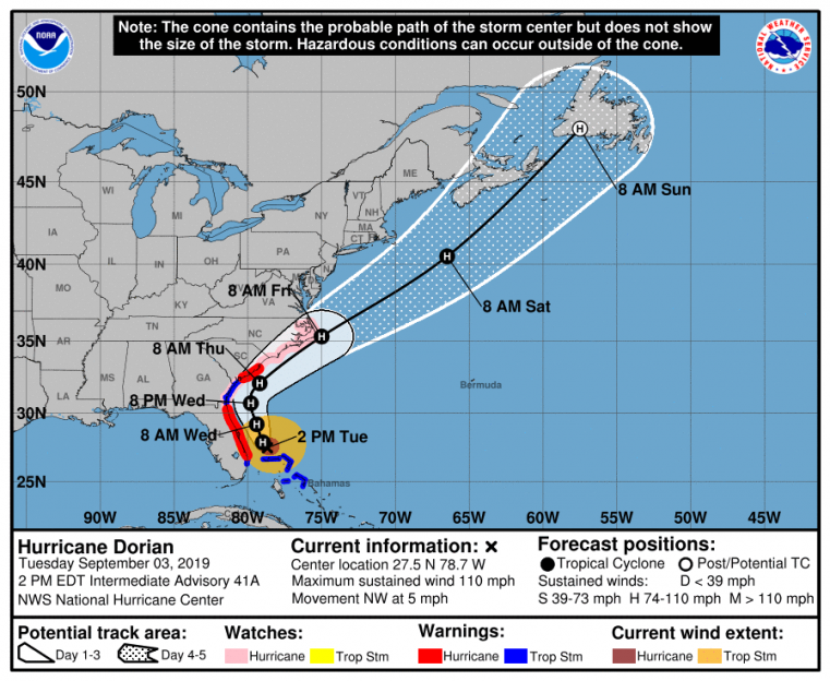
Position and Best Forecast. Source: NHC
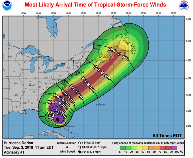
Most likely arrival time of tropical-storm-force winds and probabilities. Source: NHC
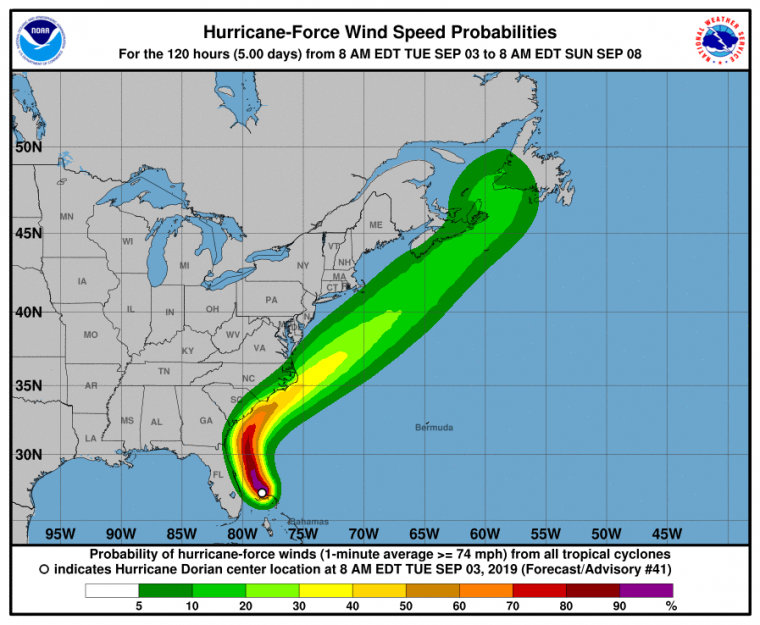
Probability of hurricane-force winds. Source: NHC
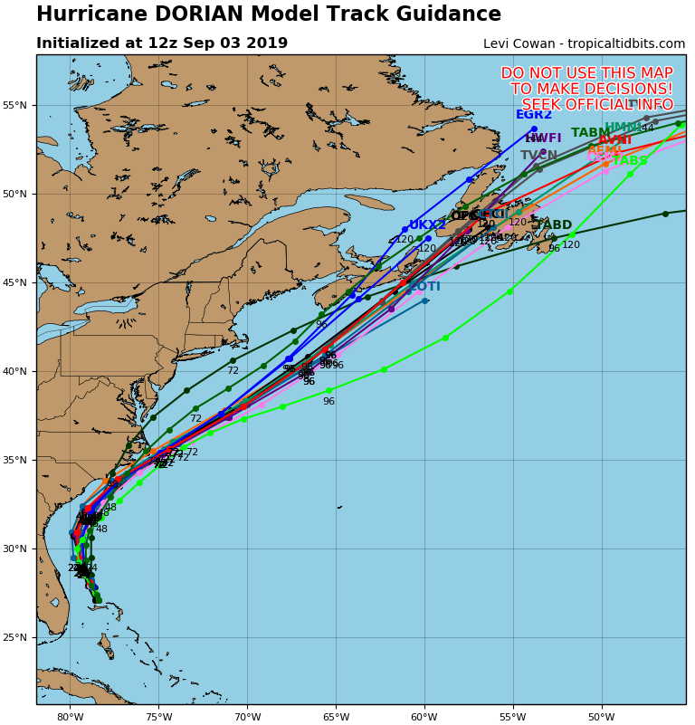
Track model guidance for Dorian. Source: tropicaltidbits.com
Concerning intensity, Dorian continues to struggle with cooler waters, dry air ingestion and increasing wind shear. However, Dorian’s track will ultimately take it over warmer waters of the Gulf Stream. Accounting for these factors and varied model guidance, the NHC best intensity forecast has Dorian maintaining strength, and approaching the Carolinas as a category-2 hurricane.
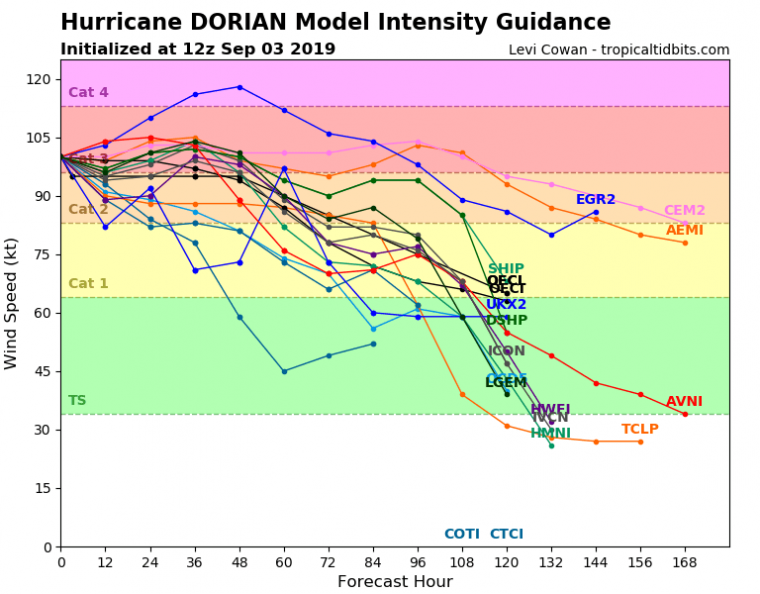
Intensity model guidance for Dorian. Source: tropicaltidbits.com
Dorian will continue to render significant impacts to the northwestern Bahamas while it clears the area today. Storm surge, hurricane-force winds and inland flooding due to excessive rainfall accumulation will continue for areas already known to have suffered catastrophic impacts in the area.
For the United States mainland, coastal flooding due to storm surge is an ongoing apparent threat that will continue as Dorian moves offshore along the Atlantic Coast. The King Tides, coupled with the persistent onshore to parallel flow and wave action from Dorian, have already amplified storm surge effects for the Florida Atlantic Coast. Some property damage has already been reported by media in immediate coastal areas in northeast Florida. As Dorian follows a track offshore of the Southeast Atlantic coast, several factors will amplify the storm surge threat over the coming days. These include a persistent onshore to parallel flow, the expected expansion of the storm, the offshore slope (bathymetry) along the Carolinas and the funneling effect of local bays and inlets. Potentially destructive coastal flood impacts can be expected due to seawater inundation, water velocity and waterborne debris for coastal areas and connected waterways, with more severe damage due to wave battering and beach erosion along the immediate coast.
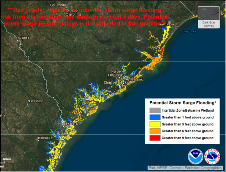
Potential Storm Surge Flooding Map (Inundation). From 11AM EDT September 3 to 2PM EDT September 7. Shows water height that has about a 10 percent chance of being exceeded. Source: NOAA/NHC.
Meanwhile the threat of hurricane winds is still possible for portions of Florida and Georgia, but with diminished expected severity as compared to recent days. Hurricane conditions also remain a threat for coastal areas of the Carolinas. In the meantime tropical-storm-force winds threaten areas from Florida to the Mid-Atlantic over the coming days, to bring impacts of downed trees and powerlines and resulting power outages, along with light property damage. Wind impacts will be most severe in near-coastal areas with amplified impacts for areas near or adjacent to the core of the storm should it move onshore in the Carolinas. Tropical storm winds are possible in New England but less probable during the day Friday, but very probable for affected areas of Atlantic Canada.
Rainfall amounts will depend closely on the exact track and forward speed of the storm, but range on the order of 6-10 inches with locally higher amounts for near-coastal areas. Flooding and flash-flooding will be a resulting potential threat for inland areas.
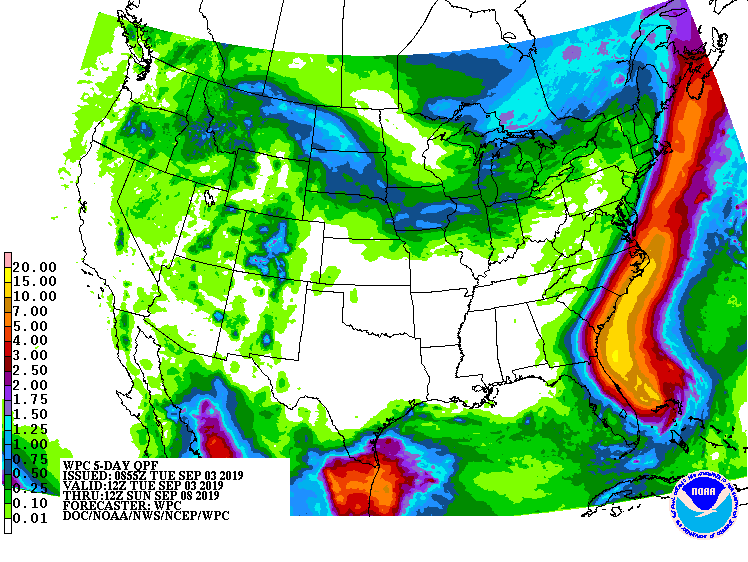
Precipitation Forecast for 5-Days Ending 8AM EDT (12 UTC) Sunday September 8. Source: NOAA/WPC
The NHC and Local Offices maintain watches and warnings for areas under potential or immediate threat. Specifics can be found at www.nhc.noaa.gov, www.weather.gov, and official government agencies. Official watches and warnings, and statements from emergency management agencies supersede this update, and should be closely followed concerning matters of personal safety.
Next Update The next Weather Sentinel update will be issued tomorrow. For up to date, official information, the following websites are recommended:
National Weather Service, Melbourne, FL
National Weather Service, Jacksonville, FL
National Weather Service, Charleston, SC
National Weather Service, Newport/Morehead City, NC
South Carolina Emergency Management
North Carolina Emergency Management
Subscribe to Guy Carpenter Email Alerts on Real Time Activity
To receive email notifications of Weather Sentinel updates, please click on this link to update your preferences.
https://go.guycarp.com/preferencecenter
Additionally, in response to client demand, we are pleased to offer daily email alerts for any tropical cyclone occurring globally. The GC Global Tropical Cyclone Alert discusses active tropical cyclones across the globe, portraying a graphical forecast and brief commentary on intensity forecast changes expected over a 24 hour period. Fill out the form at the link below to start receiving our key insights.