
Several fires ignited across the state of California in late October 2019, and grew quickly under extreme fire weather conditions. As of Friday morning October 25, 2019, 49 structures have been destroyed in the Kincade Fire, burning in Northern California near Geyserville, while the Tick Fire in Southern California has jumped Hwy 14 and is threatening communities near Santa Clarita. Fire weather conditions have lessened somewhat in the northern part of the state, however extreme fire weather is expected to continue through the weekend from Los Angeles south to San Diego.
Kincade Fire
The Kincade Fire ignited near the Geysers in Santa Rosa County overnight on October 24, and quickly grew to threaten structures and force evacuations in the community of Geyserville. The fire exhibited extreme fire behavior, including long range spotting ahead of the main fire line, as well as wind driven rapid growth. As of Friday morning, the fire has burned 16,000 acres, has destroyed an estimated 49 structures and is only 5% contained. Firefighters expect to take advantage of lighter winds today to achieve additional containment.
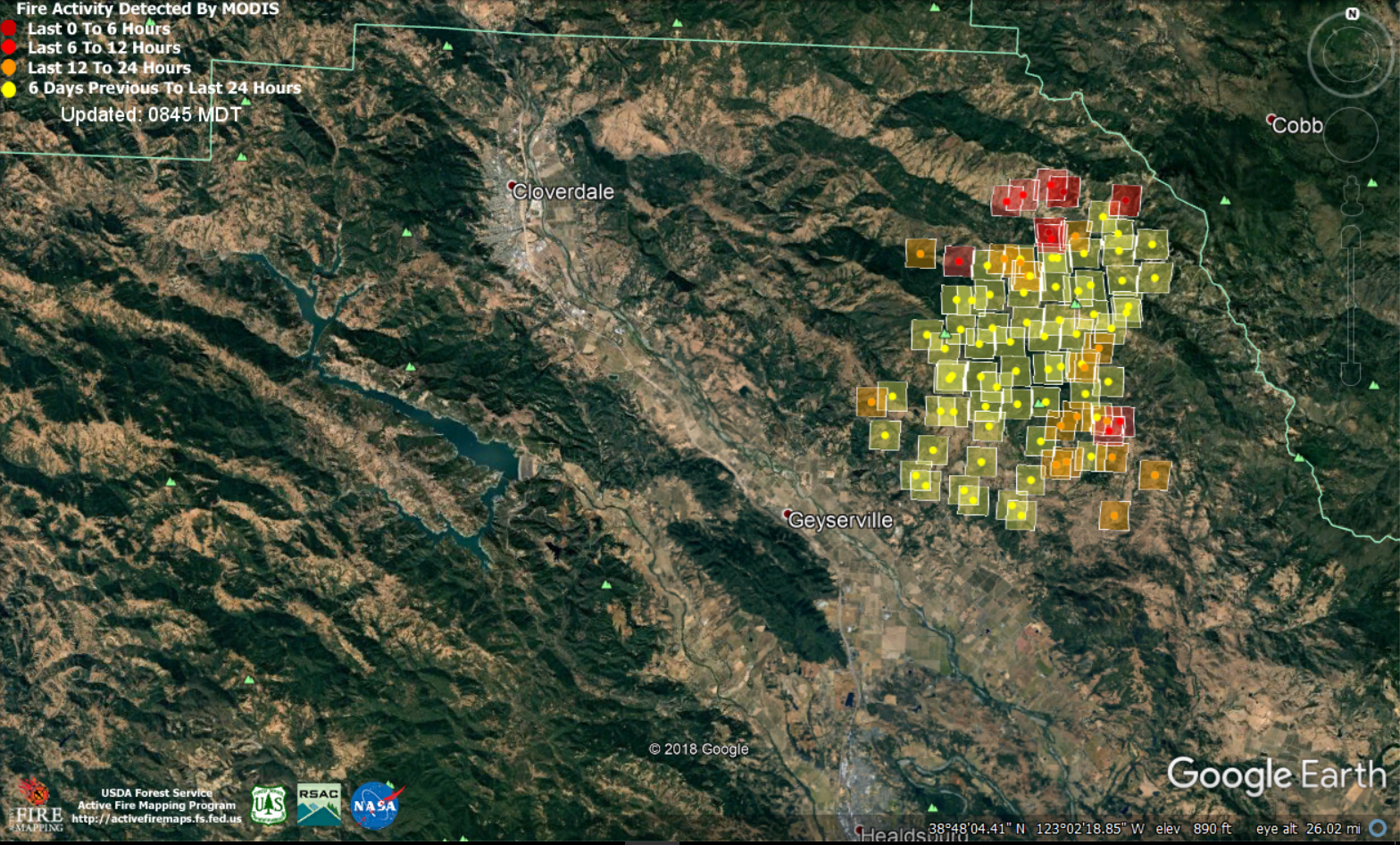
Approximate location of the Kincade Fire in Santa Rosa County. Fire Detection in last 6 hours (dark red), last 12 hours (red), last 24 hours (orange), beyond 24 hours (yellow) Source: USFS/MODIS
Tick Fire
The Tick Fire ignited in Southern California, near Santa Clarita, and has quickly grown to 4,500 acres. The Los Angeles Fire Department estimates that over 10,000 structures are threatened, and an unknown number have already been destroyed. Nearly 600 firefighters are on scene, as the fire is being driven by a strong Santa Ana wind event that is expected to peak around mid-day in the region. Winds are strong and variable, meaning that spread could be rapid and the direction of spread could be unpredictable. These conditions will pose a challenge to firefighters as they attempt to build containment lines and protect structures. Over 40,000 residents in the area are currently evacuated.
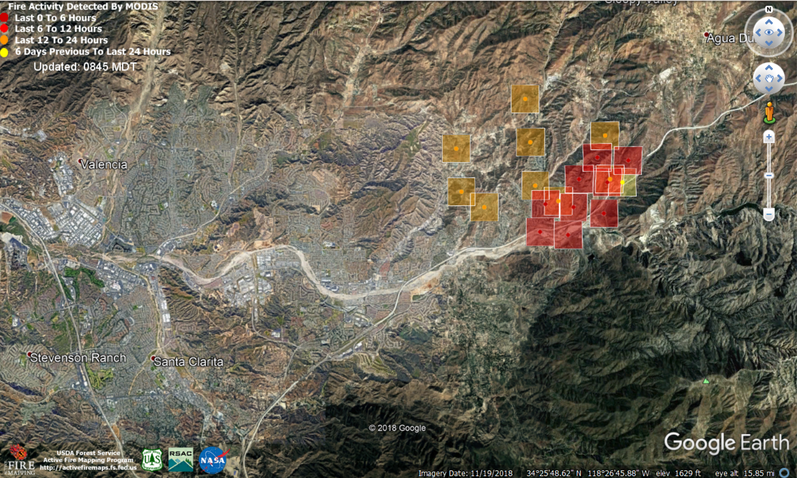
Approximate location of the Tick Fire near Santa Clarita. Fire Detection in last 6 hours (dark red), last 12 hours (red), last 24 hours (orange), beyond 24 hours (yellow) Source: USFS/MODIS
Fire Weather Conditions
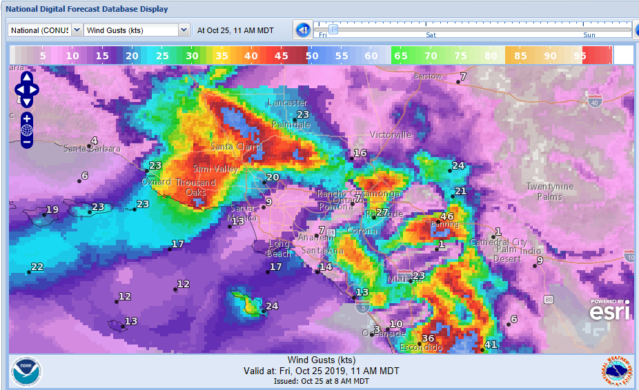
While winds have weakened today in Northern California, Southern California is experiencing a strong Santa Ana wind event which is expected to produce 45-60 mph gusts in the region throughout the day on Friday. These winds are coupled with high temperatures into the 90's and very low relative humidity. A population of nearly 3.5 million people are experiencing Critical Fire Weather Conditions today, according to the Storm Prediction Center, while isolated areas in the Laguna Mountains are experiencing Extremely Critical Fire Weather Conditions.
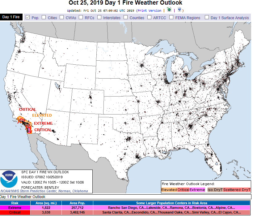
Fire Weather Outlook today. Pink – Extremely Criitical risk; Red – Critical risk; Orange – Elevated risk. Source: NOAA/SPC
A strong Santa Ana wind event is in place at the moment, which is expected to peak during the day on Friday, and calm by the evening. LA and Ventura counties are under an extreme Red Flag Warning, indicating the potential very rapid fire growth and extreme fire behavior should a fire ignite during this event. Overnight, wind gusts of up to 80 mph were observed in the mountains east of San Diego. Longer range, another Santa Ana event is possible Sunday night into Monday.
Wind Gust Forecast valid for 11 am MDT Friday, indicating areas of wind gust greater than 45 mph (red) and greater than 55mph (blue). Source: NOAA/NWS
The Hot-Dry-Windy Index (HDW) was designed by the US Forest Service to help determine which days are more likely to have adverse atmospheric conditions that make it more difficult to manage a wildland fire. It combines weather data from the surface and low levels of the atmosphere into a first-look product. The dark brown shading in the map below indicates areas in which the weather conditions, most specifically temperature, relative humidity and wind, are highly conducive to wildfire (in terms of daily percentile rank of historical weather conditions meaning a higher number indicates more extreme conditions).
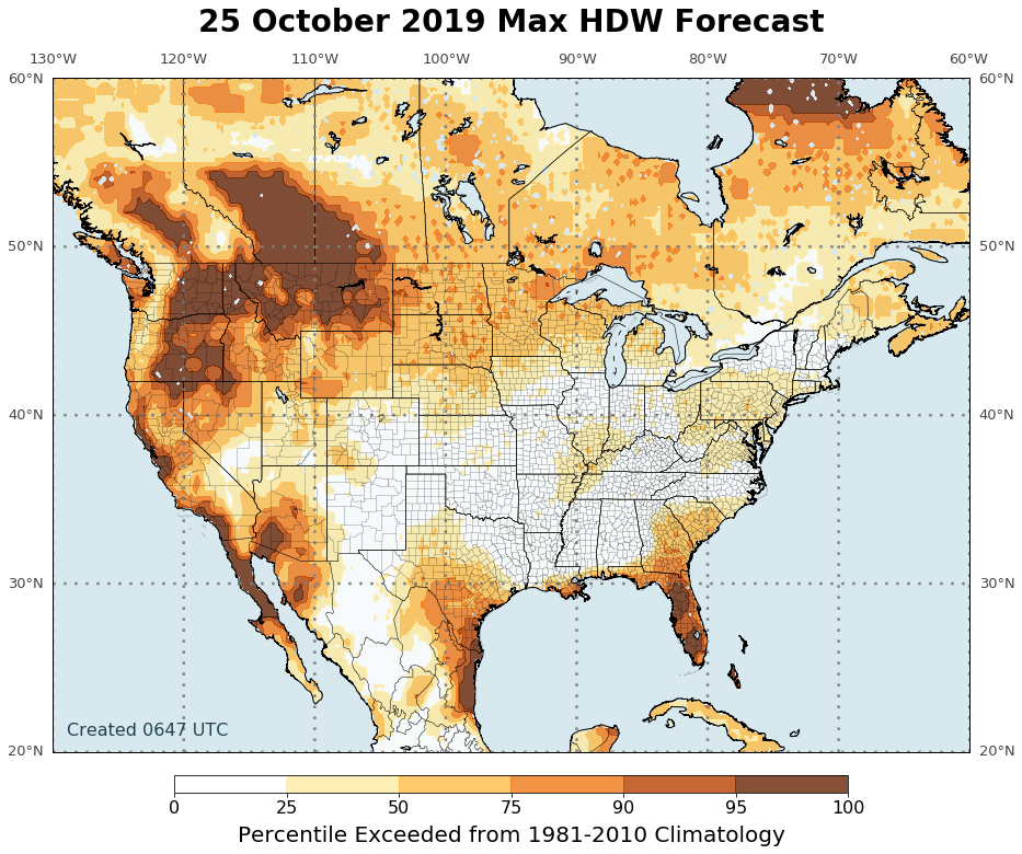
Hot Dry Windy Index (HDW) for Friday October 25, indicating areas at risk for more extreme fire weather conditions in brown.Source: USFS
This report was compiled with integrated information from the public agencies listed below. Regional conditions can vary depending on local weather conditions. Interested parties can monitor the sites below for updates and developments, and statements from these sites supersede this update.
NOAA/NWS Storm Prediction Center
California Department of Forestry and Fire Protection (CalFire)