
Bushfire activity in the last few months has rendered significant impacts to portions of Australia, and especially so in recent weeks with severe impacts reported in New South Wales. The bushfire activity has caused devastating impacts to human life, property, infrastructure, and wildlife. Extreme fire weather conditions across the country together with record heat and drought from 2019 have caused at least 7.3 million hectares to burn. Media reports indicate at least 25 fatalities and over 2,000 homes destroyed. Recent weather has brought some relief for containment efforts, but Fire Weather Warnings issued by the Australian Bureau of Meteorology (BOM) continue to remain in place for many areas. Numerous fires remain active in the region and damage assessments are ongoing. The Insurance Council of Australia estimates insured losses on the order of AUS 700 million as of January 7.
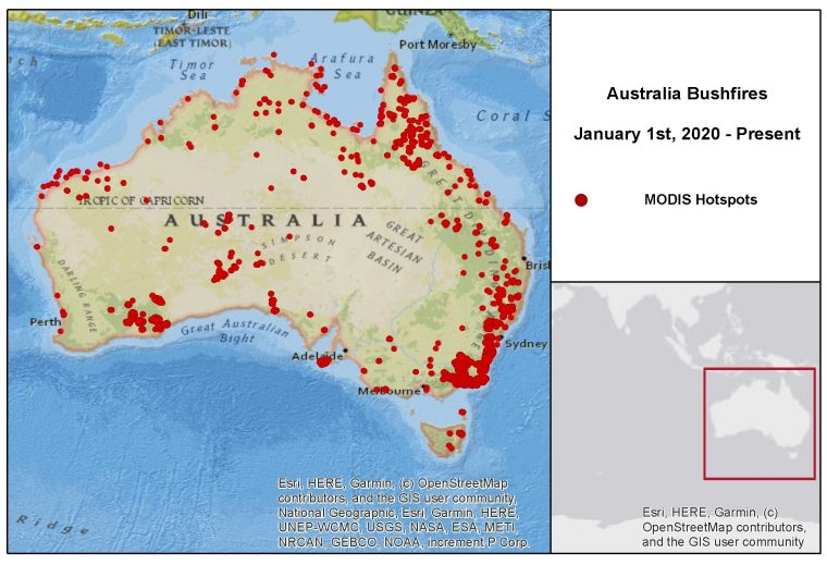
Hotspot data (satellite-detected), aggregated from January 1-January 7. Source: NASA/MODIS.
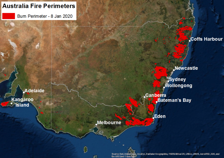
Bushfire burn perimeters for New South Wales, Victoria and South Australia as of January 8. Source: NSW Rural Fire Service , VicEmergency, SA CFS.
Physical Discussion
2019 was one of the hottest and driest years for Australia in the known historical record – an apparent trend over recent decades. Prolonged periods of exceptionally high temperatures and lack of rainfall last year produced extremely dry fuels. Hot and dry conditions in recent weeks have enabled periods of extreme fire spread, especially during windy periods.
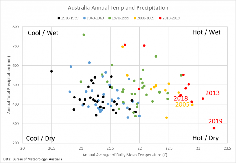
Australia annual average temperature and precipitation. Source: BOM.
Weather systems in play over the coming days include a ridge of high pressure covering large areas of the continent. A passing weather disturbance to the south may bring some rainfall to southern and eastern regions. This may temporarily reduce the threat of extreme fire spread but also impede the efficiency of preventative burns as part of containment efforts. Gusty winds will remain a concern as the disturbance crosses the area. Meanwhile, Tropical Cyclone Blake should bring heavy rain to Western Australia over the coming days. For the longer term, the BOM is expecting seasonal temperatures from January through March to remain above-median for much of Australia, with generally below-median precipitation for the east and above-median precipitation for the west.
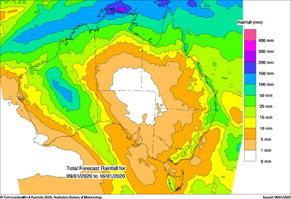
Total forecast precipitation January 9-16 (mm). Source: BOM.


Impacts
According to media reports, over 2,000 homes have been destroyed and thousands have been rendered homeless. Estimated insured losses have recently increased and are on the order of AUS 700 million, with 8,985 claims since September, as reported January 7 by the Insurance Council of Australia. These numbers should be expected to change as damage assessment efforts continue. Additionally, an estimated 800 million mammals have been killed since September, according to University of Sydney ecologists. Air quality and human health have also become a significant concern for affected areas due to smoke transport, even away from immediate burn locations. Poor air quality has caused disruption or cancellation of retail, sporting events, festivals, flights and mail delivery in certain areas, according to media reports.
New South Wales
New South Wales has suffered especially severe impacts, where media reports indicate at least 18 fatalities as of January 6. Over 1,500 homes have been confirmed destroyed and an additional 650+ structures are reported damaged. Over 200 facilities have been destroyed or damaged in addition to over 4,000 outbuildings. Impacts to the South Coast have been quite severe resulting in the loss of local businesses and farms, power outages and the issuance of an unprecedented "tourist leave zone". Meanwhile in Balmoral, a small town located southwest of Sydney, substantial damage occurred on December 21 when a significant portion of the town was burned. Heavy damage was also reported by media in Cabargo and Mogo. The full scope and severity of the wildfire season will become more clear as the situation unfolds and damage assessment efforts continue.
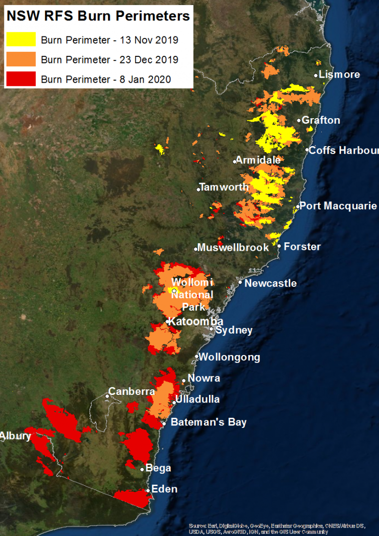
New South Wales burn perimeters as of November 13, December 23, and January 8. Source: NSW Rural Fire Service.
Victoria Further south, impacts are of reduced scope but remain severe. Local media reports indicate over 200 homes in the state have been destroyed, and the number is anticipated to increase. A number of those were located in Mallacoota, a coastal town where beachgoers were forced to flee the shore on December 31.
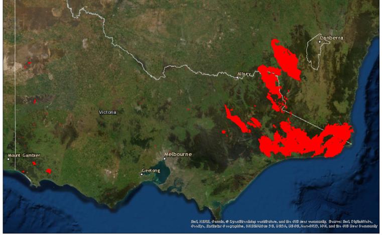
Victoria Bushfire burn perimeters as of January 8. Source: VicEmergency.
Other Areas
Across the rest of the country, fires continue to burn rendering impacts to human life, property, and wildlife. In South Australia, the Cudlee Creek Fire is responsible for destroying more than 80 homes in the Adelaide Hills region. At least 80 additional homes have also been destroyed in the state. On Kangaroo Island, 56 homes have been confirmed destroyed in addition to 236 outbuildings and 257 vehicles were damaged. In Queensland, over 250,000 hectares have been burned and 48 homes have been destroyed. In the meantime, three, five and two homes have been destroyed in Western Australia, the Northern Territory, and Tasmania, respectively.
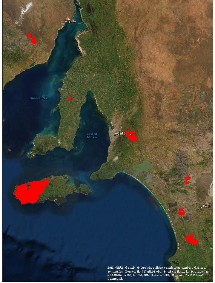
South Australia burn perimeters as of January 8. Source: SA CFS.
Sources: Australian Bureau of Meteorology, Insurance Council of Australia, CNN, RMS, BBC News, The Weather Channel, SA CFS, NSW CFS, VicEmergency.