
Severe thunderstorm activity affected large parts of Victoria, Canberra, Sydney and South-East Queensland from January 19-21. The storms produced large hail, damaging winds and flash flooding in many areas across these states. According to the Australian Bureau of Meteorology (BOM), there were ground reports of hail of up to 5 cm (2.5 inches) in diameter across Canberra, Sydney’s south-west and parts of Melbourne. Initial damage reports indicate that the suburbs of Belconnen in Canberra, Campbelltown in Sydney and Glen Iris in Melbourne were the most severely affected. The Insurance Council of Australia reports estimated insured losses on the order of at least AUD 514 million as of January 23.
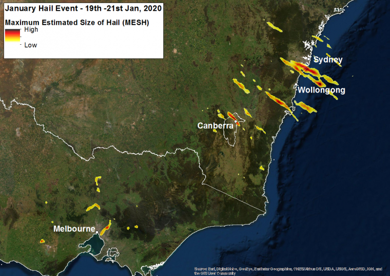
Hail swaths for January 19-21 (radar-estimates). These are cloud-level estimates as detected by radar, and some differences should be expected between these estimates and actual ground reports. Source: Joshua Soderholm (Bureau of Meteorology) and Jordan Brook (University of Queensland).
Meteorological Discussion
Severe thunderstorm activity produced reports of hail and damaging wind gusts over the weekend and early this week for portions of southern and eastern Australia. The thunderstorm activity occurred as an upper-level disturbance and associated surface system crossed the southern and eastern portions of the continent, in the presence of moist, unstable air and robust upper-air support.
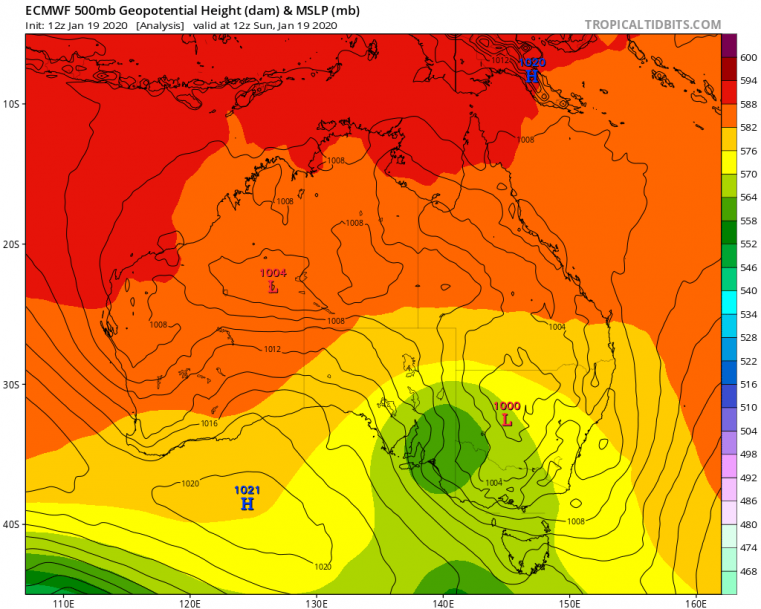
Model estimate of upper-level 500 hPa heights (shaded) and mean sea-level pressure (lines, mb), as of 12 UTC January 19. Green shades indicate lower heights and an upper-level disturbance, with an associated surface low to the east shown by the black lines. As the system crossed from west to east over southern Australia it initiated thunderstorm activity ahead of it. Source: tropicaltidbits.com.
On Sunday thunderstorm cells initiated around Kinglake near Melbourne and then moved across Melbourne, where activity appeared to intensify around 4:00 PM to 4:30 PM (local time). Another storm cell initiated near Broadford north of Melbourne just after 5:00 PM and then tracked toward Lancefield. The storm cells then dissipated shortly after 7:00 PM.
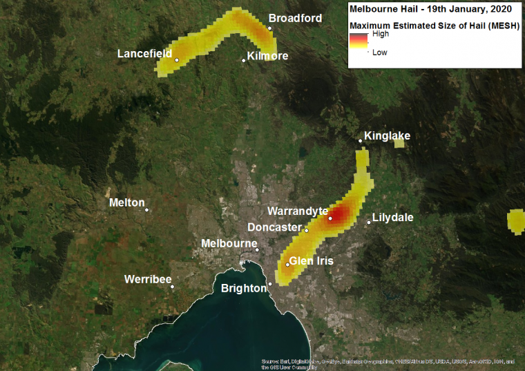
Hail Swaths for the Melbourne region (radar-estimates); Source: Joshua Soderholm (Bureau of Meteorology) and Jordan Brook (University of Queensland).
On Monday the BOM issued severe storm warnings for Canberra for large hail, damaging winds and heavy rainfall. The storm cells started just before 12:00 PM (local time) near Canberra. The cells then moved toward Canberra, where they intensified, hitting Canberra around 12:45 PM. The storm cells then moved in a south-easterly direction toward Red Hill and then toward the coast where they dissipated around 2:00 PM. According to radar hail estimates, the largest estimated hail-sizes occurred around Canberra CBD, with approximately 7 cm diameter hail.
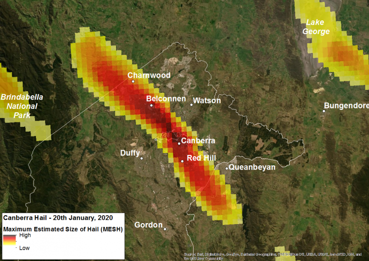
Hail Swaths for the Canberra region (radar-estimates); Source: Joshua Soderholm (Bureau of Meteorology) and Jordan Brook (University of Queensland).
Later in the day the BOM issued further warnings for severe storms in the Sydney region, Gosford/Wyong and Greater Wollongong areas. The first storm cells initiated around 2:30 PM to Sydney’s south-west, before moving toward the coast where they intensified over the suburbs near Campbelltown. A second storm cell began around the south-west region and then intensified over Bundeena near the coast. According to radar hail estimates, the largest estimated hail-sizes occurred around Bundeena to Sydney’s south with approximately 7 cm diameter hail.
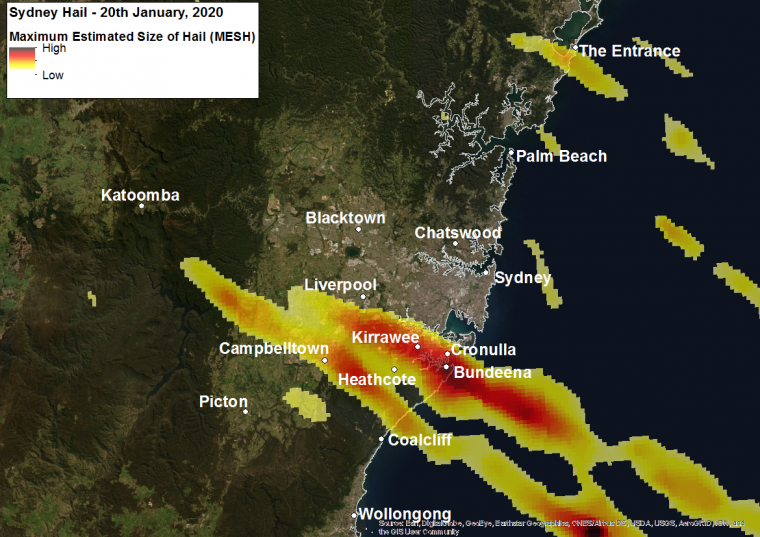
Hail Swaths for the Sydney region (radar-estimates); Source: Joshua Soderholm (Bureau of Meteorology) and Jordan Brook (University of Queensland).
In addition to hail, significant rainfall was recorded across the South-East Queensland region on January 21. According to the BOM, rainfall totals exceeded 50 mm in several areas of the Gold Coast, Brisbane and Sunshine Coast. The rainfall produced flash flooding in several locations. There were also reports of damaging wind gusts of more than 116 km/hr at Canberra Airport, escalating the potential of wind-blown hail damage to building cladding and windows.
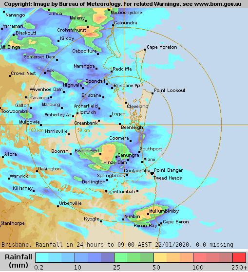
Rainfall estimates for 24 hours ending 9:00 AM EST January 22. Source: BOM. Severe weather may continue to affect the east coast over the next few days. For several cities, January is one of the peak months for large hailstorms, which traditionally begins during the month of October and wanes into April. (Source: Guy Carpenter & Bureau of Meteorology historic radar data).
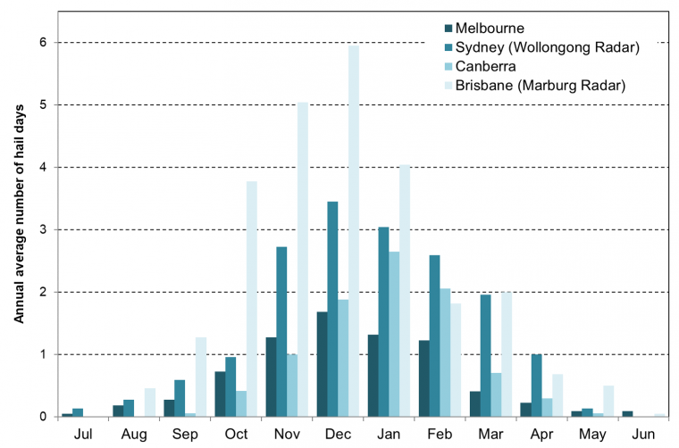
Average number of hail days based on the Bureau of Meteorology radar derived hail database. Annual hail days for each region are defined as the count of days where a hail footprint is observed within 120 km of the radar site, and where the measured hail size is greater than 2 cm. Source: Guy Carpenter based on the BOM radar archive.
Impacts
Based on initial damage reports from the media, there has been a large volume of claims, with most numbers coming from Canberra and Sydney south. In Canberra, there were reports of 4-5 cm hail measured on the ground, with damages particularly concentrated around Belconnen. The Australian National University was severely impacted, with damage to more than 80 buildings, as well as damage to cars. There has been extensive damage to about 65 glasshouses at CSIRO’s Blackmountain site, which will set back the research undertaken at the sites. There have also been reports of thousands of motor vehicles damaged across Canberra. I
n Sydney, the State Emergency Service has received high volume of calls around the Sutherland Shire, with reports of greater than 5 cm hail on the ground in Campbelltown and 4.5 cm hail in Oran Park. There have also been reports of “golf to cricket ball” sized hail in the Hunter region. Meanwhile in Melbourne, the most severely affected areas were to the north and east of Melbourne, with reports of 5 cm hail on the ground around Glen Iris in the east.
The Insurance Council of Australia (ICA) has declared a catastrophe for the storms (CAT201) which affected Victoria, Canberra, Sydney and South-East Queensland. The scope and severity of the event remain in the early stages of development as damage and claims assessment efforts continue. The ICA reported on January 21 that insurers received at least 29,000 claims, with estimated insured losses on the order of AUD 320 million, with additional claims expected. Around two thirds of claims are for damage to motor vehicles, according to the ICA statement. A recent update from the ICA on January 23 indicates that at least 55,650 claims have been reported, with estimated insured losses on the order of AUD 514 million.
The table below provides a comparison of maximum reported hail sizes and loss estimates for historic hail events, based on ICA disaster statistics.
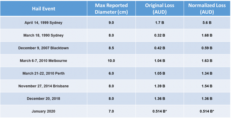
Comparison of reported hail sizes and insured losses for historic hail events. *January 2020 loss estimate as of January 23, 2020. Source: ICA Sources: Australian Bureau of Meteorology, Insurance Council of Australia, ABC News, SBS News, the Australian, Reinsurance News, Reuters, Agence France Presse.