
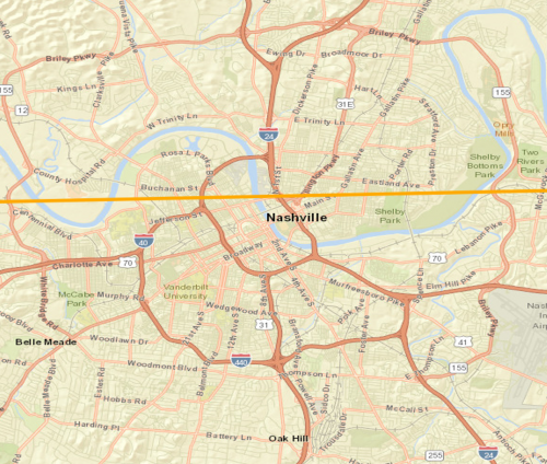
In the early hours of March 3, 2020, severe thunderstorms spawned multiple tornadoes in Middle Tennessee, including an EF-3 tornado affecting parts of Nashville and a stronger EF-4 tornado in Putnam County. Media reports indicate at least 24 fatalities statewide. Extensive damage to property and infrastructure has been reported in affected areas, with at least 50 homes completely destroyed and many more damaged. At least 73,000 homes and businesses were without power due to damage to both substations and primary distribution lines.
Physical Discussion
Thunderstorm activity for the period was initiated along and ahead of a strong frontal boundary running from the Southern Plains to the Great Lakes. The boundary separated warm, moist and unstable air from colder, drier air to the north and west. Several areas of low pressure were embedded and followed the boundary. A cluster of showers and thunderstorms formed early in the evening of March 2 as the front progressed south of the Great Lakes region into the mid-Mississippi River Valley. Stronger thunderstorms then initiated in the mid-evening hours in southeastern Missouri as southerly winds reached the front in the vicinity of the Kentucky-Tennessee border. The main supercell that produced the long track tornado through Nashville formed in a region of optimal wind shear with significant change in both wind direction and wind speed with height. The combination of optimal wind shear with enhanced moisture on southerly winds from the Gulf of Mexico sustained the supercell thunderstorm for nearly five hours. In addition to significant long track tornadoes, the supercells produced hail up to baseball size as well as severe wind reports.
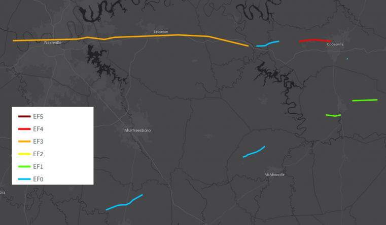
Confirmed tornado tracks affecting the Nashville and Putnam County areas. Source: NOAA/NWS.

Local Storm Reports from March 2. Source: NOAA/SPC.
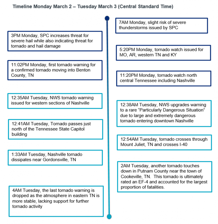
Timeline of the event. Source: NOAA/SPC/NWS.
Historical Context
Several questions emerge after an event such as the Nashville tornado:
1) How often are major U.S. cities hit directly by tornadoes? The map below shows some tornadoes that have struck metropolitan areas, color coded by EF scale, since 2000. Six of the 15 tornadoes to strike major cities transpired in 2011, the highest SCS loss year on record for the industry. 2019 was the second most active strike year for U.S. cities.

Analysis of major cities affected by tornadoes in the 21st century. Source: Guy Carpenter, NOAA/SPC Historical Tornado Data.
2) Is Nashville prone to tornadoes? Yes, the north central part of Tennessee is an area that has historically seen tornado activity. Specifically, for downtown Nashville, the March 14, 1933 tornado was rated an EF-3 tornado with a path length of 45 miles and 15 fatalities. The April 16, 1998 tornado was also rated an EF-3, with a path length of 32 miles. In contrast to 2020 and 1933, which occurred in the evening, the 1998 event occurred during the day, with a lower fatality rate of only 1 person.

Historic tornadoes to track through downtown Nashville, TN. Source: NWS Nashville, TN.
3) Is it unusual to have tornadoes at night? How does this influence the mortality rate? Dr. Walker Ashley of Northern Illinois University studied nocturnal tornadoes in a research effort published in 2008. By the numbers:
29: average number of Tennessee tornadoes per year.
27%: national average of nocturnal tornadoes. 50%: proportion of all tornadoes in Tennessee that are nocturnal, the highest percentage of any state in the U.S.
250%: nocturnal tornadoes are meaningfully more dangerous as the fatality rate is 250% higher than those events that transpire during the day. I
Impacts
Nashville & Davidson County According to reports from media and the National Weather Service (NWS), a number of Nashville neighborhoods experienced damage of an EF-3 tornado, with significant damage to residential structures in areas such as Five Points and Germantown. At least 30 local businesses in East Nashville sustained structural damage, in addition to the East End United Methodist Church. About 90 people spent the night in shelters, according to local officials. The John C. Tune Airport located in west Nashville reported extensive damage to the terminal, hangar, airfield, and a number of aircraft. Areas of Tennessee State University, located west of Nashville, have also confirmed damage to rooftops, with downed trees and power lines, and debris scatter. At least three local schools have also reported structural damage. Students at the University were on spring break at the time. The storms also produced damage to a number of polling stations, causing a number of Super Tuesday voters to wait in long lines, with closing delayed by court order.
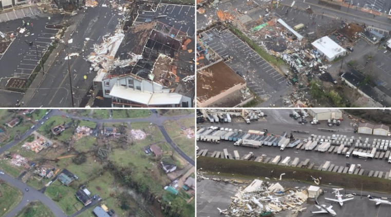
Aerial imagery of significant damage from Nashville police helicopter surveys. Source: Metro Nashville Police Department.
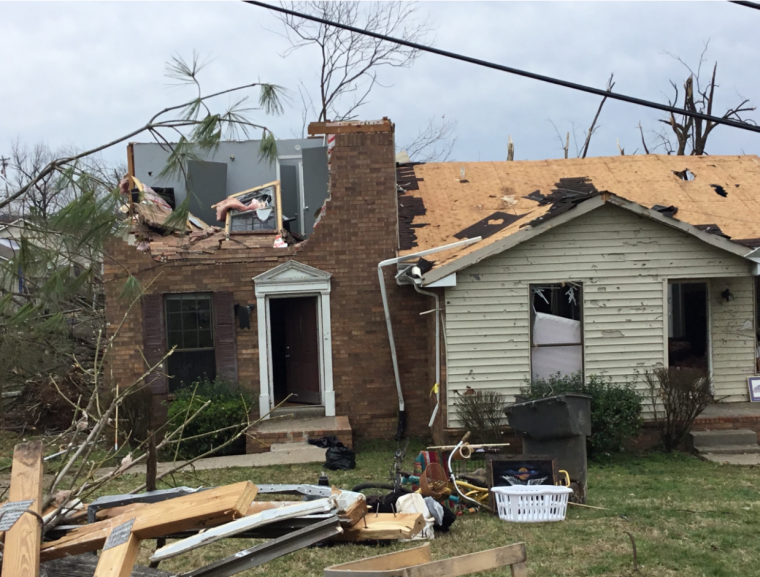
Damage to a home and office on 2nd Ave N, Nashville, TN. Source: NWS Nashville.
Putnam County
In Putnam County, a number of houses and businesses were completely flattened. Damage to at least 100 structures has been reported. More than 85 people have been injured, and at least 18 fatalities have been reported in Putnam County, including 5 children. The hardest hit towns in the county include Double Springs, Prosperity Point, Echo Valley and Charleton Square, according to media reports.
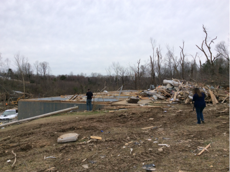
Extreme damage to a home in Putnam County, with only the foundation remaining, consistent with an EF-4 rating and estimated winds of 166-200 mph. Source: NWS Nashville. Sources: U.S. National Weather Service, U.S. Storm Prediction Center, The Weather Channel, Associated Press, Reuters, The Washington Post.