

Severe weather activity saw an uptick over the first half of April, bringing significant impacts to much of the south, central and eastern portions of the United States:
- A large storm system from April 7-9 brought widespread hail and wind in addition to a few isolated tornadoes to a broad area generally east of the Mississippi River. Significant hail and high wind reports were observed across numerous states in the Midwest, Southeast, Mid-Atlantic, and Northeast over the three-day period.
- A notable severe weather outbreak spawning multiple long-track tornadoes rendered catastrophic damage across areas of the Southeast over the Easter weekend. The storm system also brought damaging thunderstorm winds that affected much of the Atlantic Coast into the Northeast on the following Monday. More information on this event is available in the Guy Carpenter CAT-i report found here.
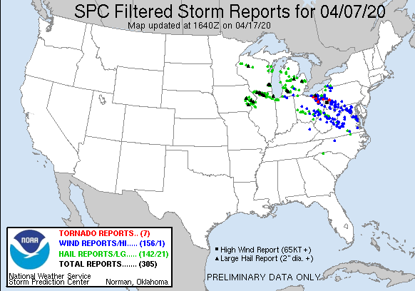
Local storm reports spanning April 7 – April 9. Source: NOAA/SPC.
The tornado outbreak on April 12-13 was one of the largest in recent years. Over 140 tornado warnings were issued between 7 am Sunday, April 12 and 7 am on Monday, April 13, marking the most individual tornado warnings issued in a 24-hour period since March of 2012. Over 100 tornadoes have been confirmed by the National Weather Service from that outbreak, including two EF-4 tornadoes in Mississippi and more than 12 EF-3+ tornadoes, which is the highest total of EF3+ tornadoes in a single outbreak since April of 2011. Also notable for the 2020 season is the number of tornado fatalities, which is the highest in since 2012.
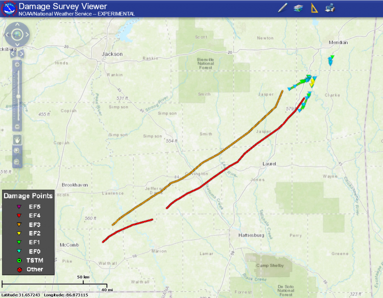
April 12 preliminary tornado tracks in southern Mississippi, including two EF-4 tornadoes. Source: NOAA/NWS Damage Assessment Toolkit.
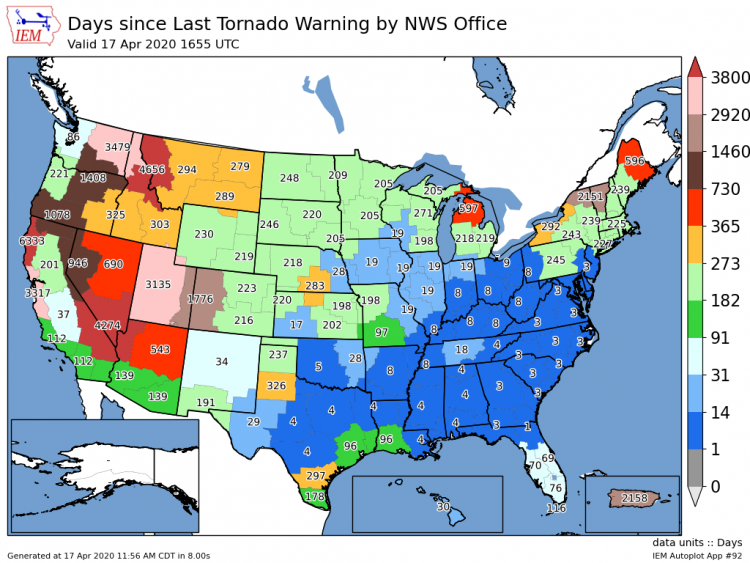
Days since each National Weather Service office last issued a tornado warning. Areas shaded in dark blue have all seen a tornado warning issued within the last 10 days, indicating the breadth of the last two severe weather outbreaks. Source: Iowa Mesonet.
Does an active April have implications for the rest of the SCS season? The heavy tornado activity in the first half of April has now put the season to date being roughly 15 percent above average. With April and May typically being the two most active months of the year for tornado activity, what does an active early April say about future prospects of an above average season overall?
- Landmark years: By far, 2008 and 2011 had the most activity of the last 15 years. While April was above average in activity in both of these years, the key timeframe for continued, elevated and exceptional activity was in the second half of May.
- Well above average: 2019 was third highest tornado total since 2005. Activity was largely average (unlike 2008 and 2011) until exceptional activity in the second half of May, similar to 2008 and 2011. Year-end tornado activity in 2019 was still well below both 2008 and 2019.
Thus, history indicates that either continued elevated activity (which looks possible through the end of April), or more prominently an active late May, largely dictates how active the tornado season ultimately will be. The below plot indicating subperil progression through the 2020 SCS season has been updated through April 17, in addition to referencing previous positions at the end of March. Damaging straight line wind reports continue to accelerate rapidly above average, while the recent tornado activity has brought tornado reports to date slightly above average, as mentioned above. Hail reports are still trending below the 2005-2015 average, but made a slight jump closer to average over the past two weeks.
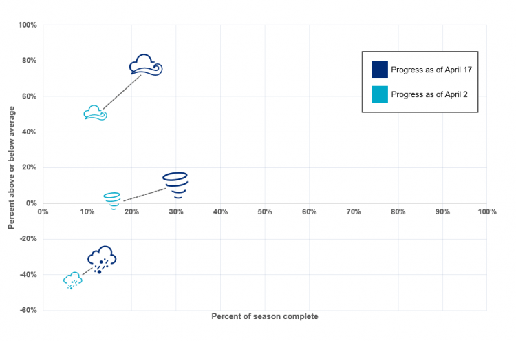
Seasonal activity to date for tornado, hail and thunderstorm wind, relative to 2005-2015 averages using SPC preliminary local storm reports. Source: Guy Carpenter, NOAA/SPC.
Forecast Scattered thunderstorms are possible leading into the weekend across southern portions of the Continental U.S. The potential for severe, scattered thunderstorms will increase on Sunday, April 19 and during the week of April 20.
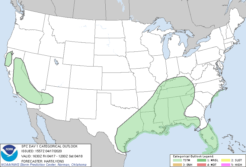
SPC 8-Day Convective outlook animation as of April 17 (afternoon). Source: NOAA/SPC.
The Extended Range Tornado Activity Forecasts (ERTAF) through April 25 shown below indicate the potential for 125 percent higher than normal severe thunderstorm activity compared to the 1985-2014 baseline. Looking further towards the end of April, the forecast shifts to average activity for the week of April 26 through May 4.
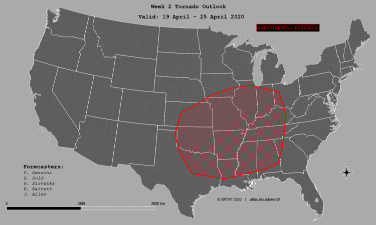
Extended Range Tornado Activity Forecasts for April 19-25. Source: V. Gensini, Northern Illinois University
For more details on Local Storm Reports, please visit the Storm Prediction Center. This issue of the Weather Sentinel is published as a series of regular communications during the 2020 US SCS season. If a significant industry threat of severe weather occurs, further communication will be issued by Guy Carpenter experts as warranted.