
In the Northwest Pacific Basin, Typhoon Vongfong made landfall in the Philippines on May 14 around 12:15 PM local time (0415 UTC), in the municipality of San Policarpo, Eastern Samar Province. Just after moving inland, the typhoon carried 1-minute sustained winds of around 185 km/hr (115 mph), a category-3 on the Saffir-Simpson Scale according to the Joint Typhoon Warning Center (JTWC).
Before entering the Philippines Sea north of Luzon, Vongfong (locally known as Ambo) rendered significant impacts in several provinces in the country, including destructive winds, flooding and landslides. The Philippine Atmospheric, Geophysical and Astronomical Services Administration (PAGASA) issued Tropical Cyclone Wind Signal advisories up to level 3 (on a scale of 1 to 5), affecting several provinces in the country. As of May 18, the National Disaster Risk Reduction and Management Council reported that 218,000 people were affected by the event, while more than 136,000 were evacuated. The typhoon left at least five dead, and more than 50 injured according to media reports. Relief efforts are ongoing and it will take time to assess the full scope and severity of the event. Our first thoughts and concerns are with those directly affected.
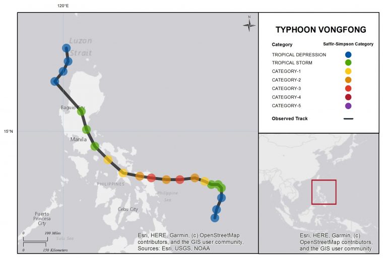
Typhoon Vongfong Best Track. Source: JTWC.
Physical Discussion
Typhoon Vongfong began to develop in early May as a low-pressure system southeast of Pulau. After the feature began to show clear signs of organized circulation, on May 5 the Joint Typhoon Warning Center (JTWC) identified it as Invest 95W and began issuing advisories. The disturbance continued to organize and gain energy and a Tropical Cyclone Formation Alert was issued by the JTWC May 10. It was later classified as a tropical depression by the Japan Meteorological Agency (JMA), the JTWC and PAGASA (which named it Ambo). The system was then over 300 km (186 miles) east of Mindanao, and approaching the Philippines with a forward speed of around 8 km/hr (5 mph).
As the system continued to approach the Philippines, model guidance indicated a high probability for it to develop into a typhoon. On May 12 the system reached tropical storm status and was renamed Vongfong, the first named storm of 2020 in the Northern Hemisphere. On May 13 the system began a period of rapid intensification, gaining typhoon status at 06 UTC May 13 before reaching peak intensity at 18 UTC May 13, with 1-minute sustained winds of around 185 km/hr (115 mph), a category-3 on the Saffir-Simpson Scale. In the meantime a Tropical Cyclone Wind Signal 1 was raised by PAGASA affecting various Philippines provinces and then upgraded to level 2 and then 3 for various areas of southeastern Luzon and Eastern Visayas in the Central Philippines.
While on final approach to the Philippines, Vongfong weakened briefly to the high-threshold of category-2 status before regaining category-3 status before landfall over San Policarpo (Eastern Samar) around 12:15 PM local time (0415 UTC) May 14. Just after moving inland, the JTWC reported 1-minute sustained winds of around 185 km/hr (115 mph), a category-3 on the Saffir-Simpson Scale, with a minimum central pressure of 962 mb. As the system continued to move over Samar, around 7 PM local time (11 UTC) PAGASA reported gusts reaching 255 km/hr (155 mph) while the eye of the typhoon was near the municipality of Catarman (Northern Samar). While tracking north/northwest at about 15 km/hr (9 mph), Vongfong began to weaken due to prolonged interaction with land, and its eye progressively started to dissipate. After the system crossed the Ticao Pass, PAGASA recorded six more landfalls in Dalupirit Island, Capul Island, Ticao Island, Burias Island, San Andres (Quezon), and Real (Quezon). On May 15 around 2 PM local time (06 UTC) the system had weakened to a severe tropical storm while moving at a forward speed of around 20 km/hr (12 mph) towards the Laguna province southeast of Manila. By this time 1-minute sustained winds had weakened to around 110 km/hr (68 mph). The system continued to track northwest over the provinces of Bulacan, Nueva Ecija, Pangasinan, Benguet, and Ilocos Sur. PAGASA further downgraded the system to a tropical storm while it was crossing Nueva Ecija and Pangasinan. Between 18 UTC May 15 and 00 UTC May 16 (7 AM local time), Vongfong reached the coastal waters of Santa Cruz (Ilocos Sur) and began to move offshore. The storm was downgraded to tropical depression status at 00 UTC May 16, while approaching the coast of Taiwan over the Philippines Sea.
While crossing the Philippines, heavy rain and flooding advisories were issued for a number of provinces across Luzon in Northern Philippines. A total of 284 mm (11.36 inches) of rain fell in Casiguaran (Aurora), while Infanta (Quezon) reported 152 mm (6.08 inches) of rain. 93 mm (3.72 inches) of rain fell in parts of Metro Manila.
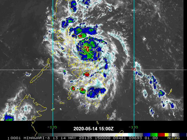
Satellite image of Luzon making landfall over the Philippines (infrared). Source: NOAA/NESDIS.
Impacts
At least five deaths and over 50 injuries have been reported in Central Luzon and Eastern Visayas, according to media statements. As of May 18, according to the National Disaster Risk Reduction and Management Council, the typhoon affected over 60,000 families or 218,000 people across Cagayan Valley, Central Luzon, Calabarzon, Mimaropa, Bicol, Eastern Visayas, and Cordillera Administrative Region. Evacuation advisories were issued for over 34,000 families or 136,000 people. The evacuation process was complicated by the ongoing CoVID-19 pandemic, with evacuation centers often not operating to their full capacity and social distancing measures implemented on a per family basis.
Local authorities reported damage to buildings and infrastructure in Bicol and Eastern Visayas. Nine medical facilities were impacted by the typhoon, and according to the Department of Education, 75 schools were damaged. Extensive damage to residential properties has been reported in Eastern Visayas, with over 1,000 houses destroyed and more than 6,000 partially damaged. Damage to residential property was also reported in the town of San Francisco (Quezon).
Vongfong brought heavy rainfall in several provinces. Flooding, downed trees and toppled electric posts temporarily rendered major roads and two bridges impassable. The typhoon affected several municipalities in Eastern Samar, including the town of Jipapad, which was severely impacted by floodwaters from a nearby river that reached the second floor of buildings. In Arteche, a warehouse and a local church were damaged, while residential and commercial buildings were impacted in the municipalities of Maslog and Oras. Meanwhile strong waves and coastal flooding caused disruption in various areas including Catbalogan City (Western Samar) and Koronadal (South Cotabato).
The Manila Public Information Office (MPIO) warned against the risk of high waves affecting the coastal areas of the capital. Despite the strong winds, the city’s Disaster Risk Reduction Management Office did not report any coastal flooding incident in Metro Manila. However, areas in the cities of Mandalauyong and Malabon in the National Capital Region were flooded. Meanwhile, a landslide caused by intense rainfall blocked the road connecting Marikina to Infanta.
Power outages were reported in eighteen provinces across the country, including Quezon, Marinduque, Camarines Norte, Sorsogon, Masbate, Western Samar, Eastern Samar, and Northern Samar. According to preliminary reports by local authorities, blackouts affected a total of 255 areas in the country. Most of Eastern Samar lost power. Infrastructure of the Northern Samar Electric Company (Norsamelco) and the National Grid Corporation were affected. As of Monday, May 18, power restoration efforts were still ongoing in several provinces. Communication lines were also disrupted, with various areas in the Island of Samar experiencing signal interruptions, including Catarman, Bobon, Lope de Vega, Mondragon, San Roque, Pambujan, San Antonio, San Isidro, San Vicente, Victoria, Biri, Allen, Capul, Lavezares, San Antonio, San Jose, and Rosario. On May 15, weak or no signal for Globe and Smart carriers was reported in the Northern Samar province.
The typhoon also disrupted marine transports, with six vessels and over 280 rolling cargoes stranded in the region of Calabarzon, Mimaropa, Bicol and Eastern Visayas. Over 200 people and 100 vehicles were stranded at the Allen Port in Northern Samar.
According to preliminary data published by the National Disaster Risk Reduction and Management Council, the heavy rains and mudslides caused estimated losses to the agriculture sector of over ₱1 billion (USD 20 million). The most affected regions are Calabarzon, Bicol, and Eastern Visayas, with the provinces of Quezon, Masbate and Camarines Sur suffering especially severe impacts. According to the Department of Agriculture, about 73 percent of losses came from damaged crops, of which 87 percent are banana and papaya production in the Quezon province. In the meantime, work in government offices was suspended in various areas in Southern Leyte, Samar, Eastern Samar, Nueva and Vizcaya.
Sources: Philippine Atmospheric, Geophysical and Astronomical Services Administration (PAGASA), Philippine National Disaster Risk Reduction and Management Council, Joint Typhoon Warning Center (JTWC), Weather Underground, CNN Philippines, Republic of the Philippines’ Philippine News Agency, Manila Bulletin, The Manila Times, Manila Stand