

Multiple rounds of severe weather impacted the United States over the second half of April. What began as a relatively quiet start to the month quickly changed one week in and maintained a steady pace of heightened activity throughout the remainder of the month. Notable headlines from the past two weeks include:
- Another weekend outbreak in the Deep South, exactly one week following the Easter Sunday outbreak, brought at least two dozen tornadoes much of the same area.
- Continued severe activity spawning numerous tornadoes later that week yet again brought significant impacts to the already battered region.
- A strong squall line swept from the Central Plains south to the Gulf during the last week of April, bringing impacts of high winds and large hail to broad area.
- The early May weekend derecho across the Tennessee River Valley likely marks the end to the multi-week stretch of active weather.
The episode on April 22-23 spawned nearly 50 tornadoes collectively in Oklahoma, Texas, Louisiana, Mississippi, Alabama, Florida and Georgia, including an EF-3 wedge tornado in San Jacinto and Polk Counties, Texas. Significant damage was rendered to a variety of structures in various areas of these states, in addition to at least 6 fatalities.
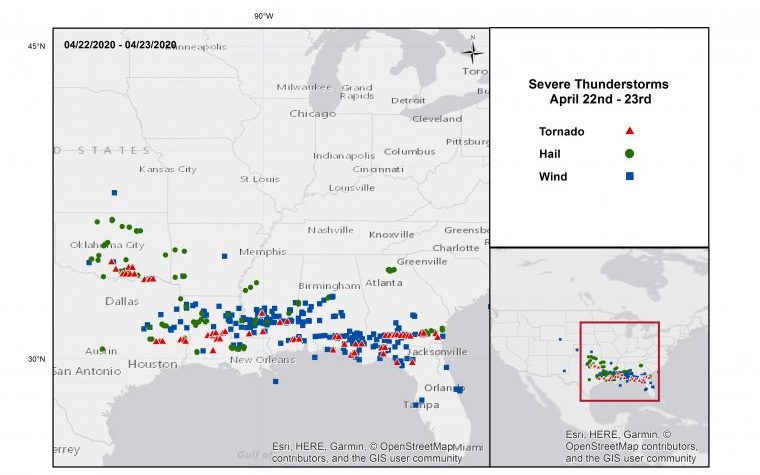
Severe Thunderstorm Reports April 22-23. Source: NOAA/SPC.
A robust squall line formed on April 28 over the Central Plains, moving south through the evening and overnight hours. Unlike the other notable outbreaks during the month of April, the primary impacts from this storm system did not include tornado activity, but rather were driven by high winds and large hail. Over 450 reports of severe weather were received within a 24 hour period. This particular squall line was classified as a derecho, a strong, fast moving, and long-lived wind storm. In order to meet the criteria of a derecho, the storm system must include a concentrated area of wind gusts of at least 58 mph, extend for 250 miles or more in length, and include several well-separated gusts of at least 75 mph, according to the U.S. Storm Prediction Center (SPC). Another derecho formed on the evening of May 3, traveling from Kansas to Tennessee.
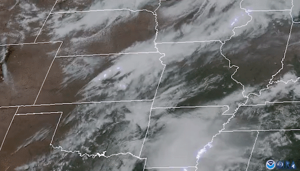
Lightning imagery via the Geostationary Lightning Mapper (GLM), GOES-16 from April 27-28 derecho. Source: D. Smith, CIRA/CSU.
Tornadoes Trending Up, Hail Trending Down
April's overall heightened activity was accentuated by an exceptional month of tornadoes. However, hail activity remained stagnant during the month of April and is currently situated well below the seasonal average. While the tornado season is trending nearly 30 percent above average and the damaging straight-line wind season is over 80 percent above average, hail activity continues to lag behind the other subperils, at more than 30 percent below average.
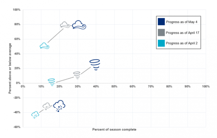
Seasonal activity to date for tornado, hail and thunderstorm wind, relative to 2005-2015 averages using SPC preliminary local storm reports. Source: Guy Carpenter, NOAA/SPC.
During the month of April, much of the contiguous United States observed colder than average conditions, especially across the north-central United States. This resulted in meteorological boundaries establishing themselves further south than normal, setting the stage for a more sheared environment favoring tornado activity, rather than a buoyant atmosphere that would favor hail production.
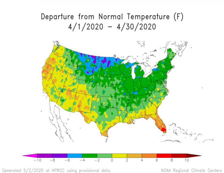
Departure from normal temperature for the month of April, indicating that much of the lower 48 was below average during the month of April. Source: NOAA/High Plains Regional Climate Center.
When examining tornado activity specifically, the uptick in April puts the season well above average. With over 300 preliminary tornadoes this past month, April 2020 ranks just second in terms of April tornado frequency since 2000, trailing only 2011. Additionally, according to NOAA, the death toll from tornadoes in 2020 in the United States sits at 73, already surpassing the yearly average only four months through the season and marking 2020 as the deadliest tornado year since 2011.

Daily Count and Running Annual Trend of US Tornadoes to date. 2020 Indicated in dark blue alongside the 2000-2018 average in light blue. Source: NOAA/SPC, Guy Carpenter
Forecast
The SPC has flagged a threat for severe thunderstorms today over the Central Mississippi Valley and Plains with a slight to enhanced risk. Significant hail of two inches diameter or more is the primary threat, along with a threat for straight-line wind gusts and a few tornadoes. The threat comes with moist, unstable air and robust wind shear, ahead of a developing frontal system crossing the area. The threat should subside and shift eastward for tomorrow per the SPC.
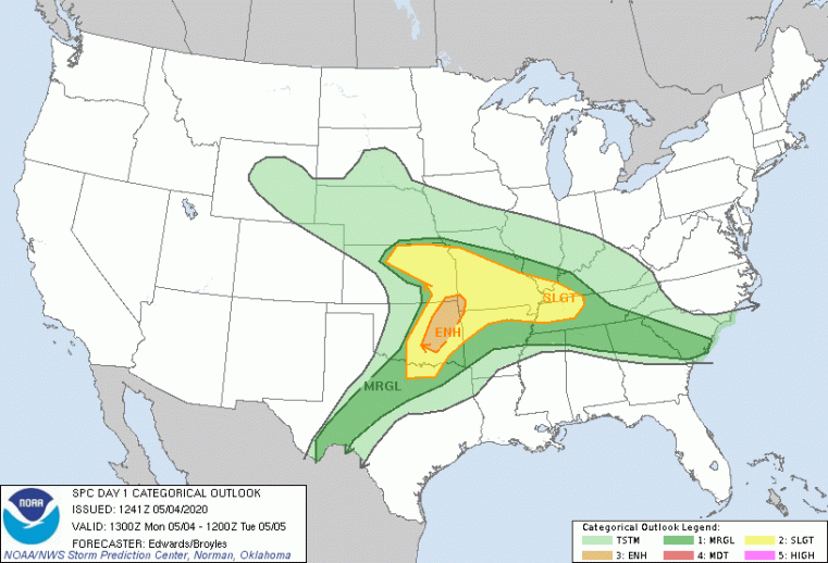
Severe Thunderstorm Outlook for May 4. Source: NOAA/SPC.
Later in the week, another disturbance should dive from western Canada into the Central U.S. The uncertain timing and potentially limited instability make it difficult to determine specifics, however a modest threat for severe weather is possible for Thursday.
For the longer term, as we head into the peak of the U.S. severe thunderstorm season in mid-May, activity is expected to shift to a below average regime from a very active April. A persistent northwesterly flow at upper levels appears likely along with unseasonably cold air over the eastern third of the continent. This will severely limit availability of warm, moist, unstable air, which are key ingredients for thunderstorm activity. Some exceptions may occur along the Northern Gulf States as a few weather systems transit the area. This is consistent with long-term guidance from the SPC through next Monday. Meanwhile the Extended Range Tornado Activity Forecasts (ERTAF) from Northern Illinois University also show below-average activity through May 16. A return to average conditions is expected in the ERTAF for the May 16-23 period, with low confidence.
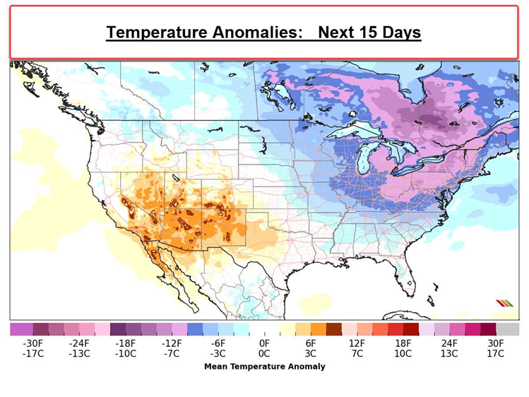
15-day temperature anomaly outlook. Source: Riskpulse
For more details on Local Storm Reports, please visit the Storm Prediction Center.
This issue of the Weather Sentinel is published as a series of regular communications during the 2020 US SCS season. If a significant industry threat of severe weather occurs, further communication will be issued by Guy Carpenter experts as warranted.