

Tropical Storm Isaias crosses Puerto Rico and Hispaniola today, causing some temporary decline in intensity. Thereafter, the NHC forecast calls for Isaias to intensify to borderline tropical storm / category-1 strength near south Florida by Saturday. Land interaction and the strength of the Bermuda high thereafter will determine the strength and track of Isaias further up the US coastline. There are several key items in play with Isaias over the next 48 hours, most pertinently the tropical storm conditions posing an immediate threat for Puerto Rico and Hispaniola (heavy rainfall, flooding, wind impacts including downed trees and powerlines along with some property damage). Several items are being actively monitored for subsequent impacts in the US and Caribbean:
- How much do the mountains of Hispaniola disrupt the circulation of Isaias?
- Does Isaias intensify slowly or more rapidly over between Hispaniola and the Bahamas and Florida?
- Will Isaias make direct landfall on the Florida peninsula? Or will the storm skirt the US coastline, raising the risk for the Southeast and potentially Mid-Atlantic US?
These questions are addressed in further detail below.
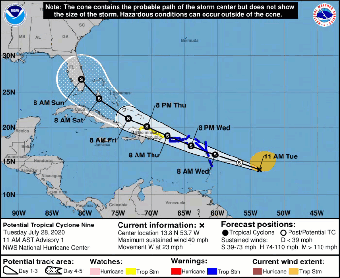
Evolution of Isaias Position and 5-Day Forecast, highlighting the extremely close approach to Florida. Source: NOAA/NHC. Discussion: Today’s discussion will address the three main questions that will ultimately determine the verification of Isaias. 1) How much will the mountains of Hispaniola disrupt Isaias? The current forecast track of Isaias, along with the bounds of the NHC cone of uncertainty, are shown in the topographic map of Hispaniola below. The mountains, with peaks to over 10,000 feet (bright white shading in map below), will in all likelihood have some immediate impact on disrupting the center of circulation of Isaias.
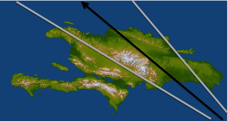
Topgraphic map of Hispaniola, with the most recent NHC cone of uncertainty and mean track overlaid. Source: NASA/JPL/NHC. However, Isaias is a very large tropical storm with winds 415 miles across. As seen in the latest satellite image as Isaias tracks just southwest of Puerto Rico, the most significant thunderstorm activity is on the south and east side of the storm center. As such, while some disruption is possible by Hispaniola, the expectation is that Isaias will rebound quickly on the north side of the mountainous island given the large footprint of the storm.
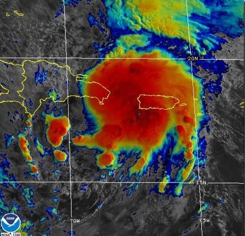
Satellite image of Tropical Storm Isaias illustrating most vigorous thunderstorm activity on the south and east side of the storm center. Source: NOAA/STAR. 2) Does Isaias intensify slowly or more rapidly over warmer than average sea surface temperatures between Hispaniola and the Bahamas? Factors that will result in slower intensification of Isaias:
- Forward speed in excess of 20 mph: While Isaias will start to slow, a storm moving this fast is less likely to intensify rapidly. Additionally, given the fast forward speed, there will only be 36 hours between Hispaniola and potential south Florida interaction.
- Large circulation center: Storms with as large a circulation as Isaias are generally slower to intensify than smaller storms. However, steady intensification appears increasingly possible.
Factors that will result in faster intensification than the current median forecast:
- Warmer than average sea surface temperatures: Ocean temperatures between Hispaniola and south Florida are running up to 1 degree C above average. Adequate ocean heat content is in place for Isaias to tap into if thunderstorm activity consolidates quickly at the center of circulation. As discussed by NHC, environmental conditions are favorable for intensification on Friday and Saturday]
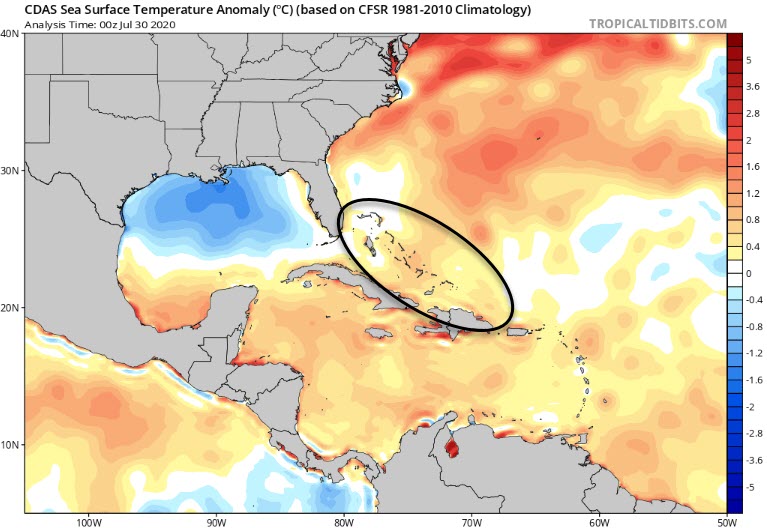
Sea surface temperatures between Hispaniola and Florida are running up to 1 degree C above average. Source: tropicaltidits.com.[/caption] Higher land interaction would temper the intensification rate, depending on the exact track. With the competing factors on intensity, the National Hurricane Center intensity forecast straddles the intensity forecast models.
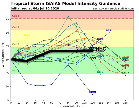
Model intensity forecasts for Isaias, with a range of models both above NHC in the category 1-2 range while other models fail to reach hurricane strength. Source: tropicaltidits.com. 3) Will Isaias make direct landfall on the Florida peninsula, or skirt along the coastline, raising the risk for Southeast and Mid-Atlantic US interests? One indication for the longer term track outcome is the animation of the NHC forecast over the last several days. Recent NHC forecast updates over the last 18 hours have started to shift the cone towards the east coast of Florida, away from the Gulf of Mexico. This is due to the high resolution hurricane models (HMON, HWRF) showing a distinct eastward trend in track over the last 36 hours, in response to a weakening Bermuda high in advance of a cold front moving through the eastern US.

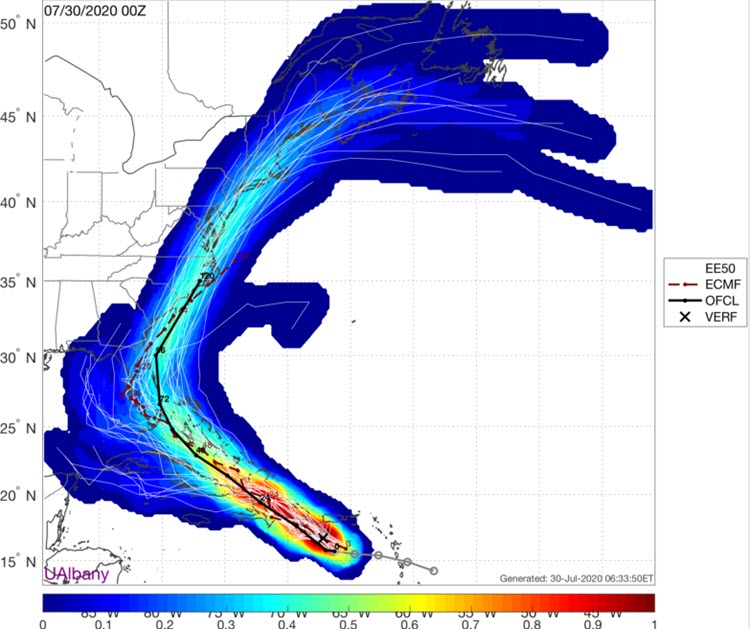
Last six model runs of the HMON high resolution hurricane model, with darker tracks issued most recently. A distinct eastward shift has been observed. Source: Dr. Brian Tang, UAlbany[/caption] With any further eastward shift, risk begins to increase meaningfully further north along the Eastern Seaboard of the United States. The European model output from overnight indicates nearly a 40 percent chance of impacts from Isaias from south Florida through New England at this juncture, based on the spread of the 51 individual runs of the European Ensemble model.
Probability map of direct impacts from Isaias based on the spread of 51 ensemble members from the European model. Source: Dr. Brian Tang, UAlbany. The next scheduled update for Tropical Storm Isaias is planned for Friday morning, July 31. Updates and Useful Links Email alerts for Weather Sentinel and CAT-i reports are available on a subscription basis at the GC Preference Center here. Daily, global tropical cyclone alerts are also available on a subscription basis here. U.S. National Hurricane Center U.S. National Weather Service Official statements from the NHC and U.S. National Weather Service, and those of emergency management agencies supersede this update, and should be closely monitored concerning matters of personal safety.