
The Atlantic Basin is entering an active phase, with two storm systems that are potential threats to the United States coastline early next week. Tropical Storm Laura is located due east of the northern Leeward Islands. It is expected to slowly strengthen to a hurricane in a favorable environment as it moves on a general track toward the Gulf of Mexico. Additionally TD14 is expected to make landfall as a tropical storm along the Yucatan Peninsula before reemerging into the Gulf of Mexico and strengthening on a general track toward the Texas and Louisiana Gulf Coast.
TS Laura Overview
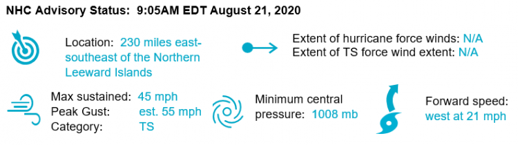
TD13 was recently upgraded by the National Hurricane Center to Tropical Storm Laura, and is moving on a general track toward the northern Leeward Islands. TS Laura will bring heavy rainfall to the Leeward Islands, the Virgin Islands and Puerto Rico, causing possible mudslides and flooding. The system will be moving through warm waters and a generally favorable atmosphere, and the expectation is for strengthening to Category 1 by late Monday as it moves toward the Gulf. Historical data indicate that the entire 5-day path of the center of the storm will remain within the cone about 60-70% of the time. This means that a landfall scenario anywhere from the Louisiana coast to the Atlantic coast of Florida is possible.

Tropical Storm Laura Position, Watches/Warnings and 5-Day Forecast. Source: NHC
TD14 Overview
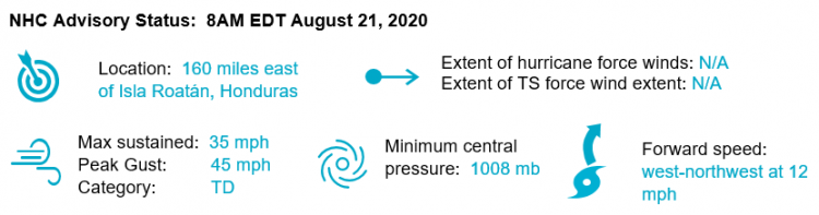
As predicted for 2020, activity in the basin is well above average, with TD14 also on a potential track toward US landfall as a named storm. Tropical Storm force wind and associated impacts are expected throughout Nicaragua, Honduras and Mexico over the next 48 hours. The National Hurricane Center forecast calls for TD14 to emerge from the Yucatan Peninsula as a tropical storm, where it will likely gradually strengthen over warm Gulf of Mexico waters as it nears the Gulf Coast.

TD14 Position, Watches/Warnings and 5-Day Forecast. Source: NH
Forecast Uncertainty
There is considerable uncertainty in the long range forecasts for both TS Laura and TD14, as highlighted in the key messages from the National Hurricane Center this morning. Currently Tropical Storm Laura is very disorganized, with a low level circulation decoupled from the upper level circulation, and encountering considerable wind shear. Laura is expected to take a path generally north of Puerto Rico, which keeps the system over warm water, and minimizes land interactions which could further disrupt the organization of the storm.
Track model guidance for the system is tightly clustered on this path between islands, giving the storm the opportunity to strengthen as it moves toward the Gulf, which is reflected in an official intensity forecast of hurricane strength by late Monday. The latest track model runs represent a somewhat meaningful shift in track to the south from the last model runs. If the track forecast continues to migrate south, it would mean greater land interaction, and less opportunity for strengthening.
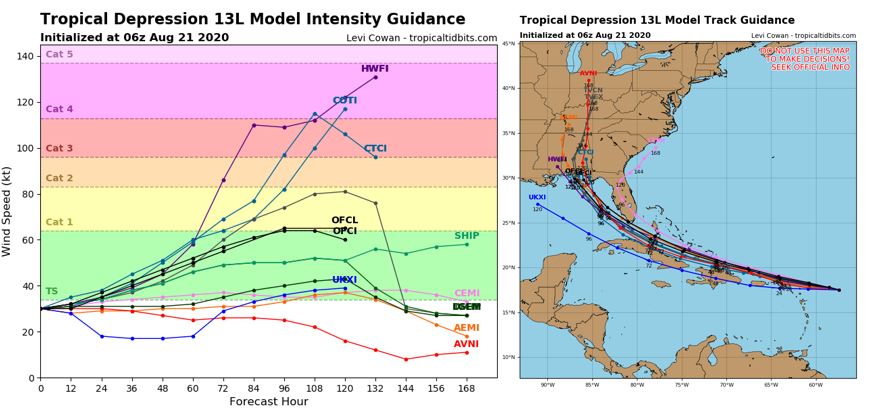
Model Intensity (left) and track (right) guidance for TD13. Source: Tropical Tidbits[/caption]
Track model guidance for TD14 shows much greater spread in potential outcomes, in response to generally weak steering currents in the Gulf of Mexico. Furthermore, TS Laura may interact with TD14 in the Gulf of Mexico as it nears landfall, which further complicates the forecast. Both storm systems have the potential to make landfall in the Gulf of Mexico early next week, however landfall location and storm strength remain highly uncertain.
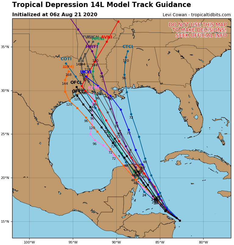
Model track guidance for TD14. Source: Tropical Tidbits
Above Average Activity
Forecasts for the 2020 season have pointed toward above average activity for months, in response to very warm ocean waters and a generally favorable atmospheric environment with low shear. Currently, sea surface temperature anomalies indicate that the Western Atlantic is approximately 1 degree warmer than average, while the Gulf of Mexico is nearly 2 degrees warmer in certain regions. These warm waters provide a fuel source for hurricanes and can lead to greater wind speeds.
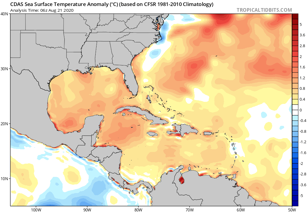
Western Atlantic SST Anomaly. Source: Tropical Tidbits
While not unprecedented, it is highly unusual for two named storms to make landfall along the US coastline at the same time. On September 4, 1933, two hurricanes made landfall within 24 hours of each other. Additionally, there have already been 5 named storms making landfall in the US in 2020 (Bertha, Cristobal, Fay, Hanna and Isaias). The record number of landfalls in the US by the end of August is 6; in 1886 and 1916. If either TS Laura or TD14 make landfall in the US next week, we would tie or surpass all existing records.
TS and Hurricane making landfall Sept 4, 1933. Source: NOAA Hurricane Mapper
Guy Carpenter meteorologists will be monitoring TS Laura and TD14 in the Atlantic Basin closely. The next scheduled update for the Atlantic Basin is planned for Monday, August 24.
Updates and Useful Links
Email alerts for Weather Sentinel and CAT-i reports are available on a subscription basis at the GC Preference Center here.
Daily, global tropical cyclone alerts are also available on a subscription basis here.
U.S. National Hurricane Center
American Meteorological Society COVID-19 & Hurricane Evacuation Guidance
Official statements from the NHC and U.S. National Weather Service, and those of emergency management agencies supersede this update, and should be closely monitored concerning matters of personal safety.