

Hurricane Isaias rendered impacts over a large area during its lifetime to include portions of the Caribbean, the U.S. Atlantic Coast and Canada. After rendering impacts due to heavy rainfall and strong winds to the Caribbean, the storm made a close approach to the Florida Atlantic Coast. Hurricane Isaias then made landfall in the Carolinas as a category-1 hurricane while producing seawater inundation and hurricane force winds along the coast. As the storm raced inland from the Carolinas to the Canadian Saint Lawrence Valley, it produced a significant tornado outbreak, locally severe flooding as well as downed trees and powerlines with resulting power outages. At least five fatalities have been reported by media as a result of Isaias.
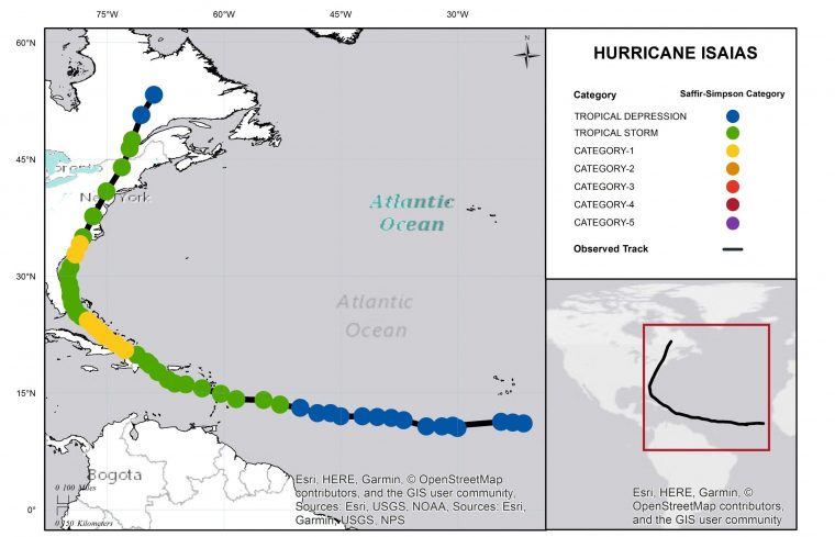
Hurricane Isaias Track and Intensity. Position reports of the tropical wave that produced Isaias are also reported from the Eastern Atlantic through the Leeward Islands to the Central Caribbean Sea together with intensity estimates. Source: NOAA/NHC.
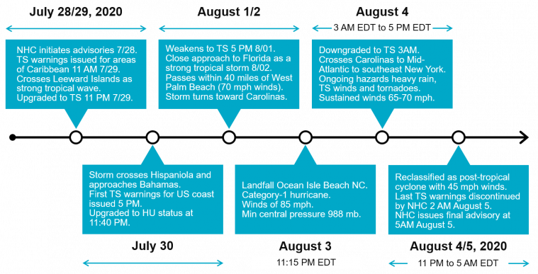
General Timeline of Hurricane Isaias from July 28-August 5. Source: NOAA/NHC.
Physical Discussion
Hurricane Isaias originated from a tropical disturbance that left Africa and crossed on a westward path across the tropical Atlantic in late July. The National Hurricane Center (NHC) identified probable development into a tropical cyclone, and began issuing advisories on July 28 while the feature was on approach to the Leeward Islands. Tropical storm watches and warnings were then issued for areas under potential threat in the Caribbean. The feature crossed the Leeward Islands on July 29 as a tropical wave with equivalent tropical-storm-force winds, while producing intense showers and thunderstorms and gusty winds. After clearing the Leeward Islands and while approaching Hispaniola, the feature developed a closed circulation with maximum sustained winds of 50 mph. The feature was then classified by the NHC as Tropical Storm Isaias at 11 PM EDT July 29. The storm took a gradual track to the northwest at this time, along the southern edge of the subtropical ridge (Bermuda High).
The system crossed Hispaniola on July 30 producing heavy rainfall and gusty winds. While the topography of Hispaniola was disruptive to Isaias, the storm already had a large footprint, with large areas of intense deep thunderstorm activity that allowed the storm to retain a great deal of its circulation, with a newly reformed center. In the meantime, the first tropical storm watch was issued by the NHC for the State of Florida at 5 PM EDT July 30.
After clearing Hispaniola, warm waters and variable wind shear allowed Isaias to gain strength while approaching the southeast Bahamas. The NHC upgraded Isaias to Hurricane status with maximum sustained winds of 80 mph, at 11:40 PM EDT July 30, following a reconnaissance mission from USAF Hurricane Hunter aircraft. The hurricane then crossed the Bahamas while producing heavy rainfall and damaging winds, affecting many areas still recovering from Hurricane Dorian (2019).
While crossing the Bahamas July 31 and August 1, the hurricane encountered increasing wind shear and ingested dry air from the surrounding environment. These factors caused the storm to lose structure and weaken. Accordingly, the NHC downgraded Isaias to Tropical Storm status at 5 PM EDT August 1. The storm then cleared the Bahamas while approaching the southeast Atlantic coast of Florida.
Tropical Storm Isaias made close approach to the Florida Atlantic coast on Sunday August 2 as a strong tropical storm with maximum sustained winds of 70 mph. The center of circulation passed within 40 miles of West Palm Beach, Florida. Portions of the Florida coast experienced heavy showers and gusty winds, while the most severe conditions remained offshore. Late Sunday into Monday, Isaias began to turn away from the Florida coast towards the Carolinas, within a steering flow between the western edge of the subtropical ridge, and an approaching disturbance over the continent. Isaias retained status as a strong tropical storm in the meantime.
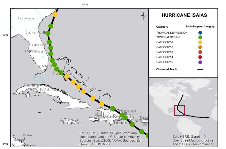
Hurricane Isaias Track and Intensity Reports for Caribbean and Western Atlantic. Source: NOAA/NHC.
As Isaias made final approach to the Carolinas, reduced wind shear and warm waters allowed it to regain strength. Accordingly, it was upgraded by the NHC to hurricane status at 8 PM EDT August 3, with maximum sustained winds of 75 mph. Just one hour later at 9 PM EDT, the NHC advised that maximum sustained winds had increased to 85 mph thanks to findings from another aircraft reconnaissance mission.
According to NHC advisories, Isaias made landfall at 11:15 PM EDT August 3 as a category-1 hurricane, with maximum sustained winds of 85 mph and a central pressure of 988 mb. The center of circulation moved inland in southern North Carolina near Ocean Isle Beach. The storm produced strong wind gusts, seawater inundation due to storm surge, and heavy rainfall with inland flooding. A rare inland observation of sustained hurricane-force winds of 76 mph was measured at Oak Island with gusts to 87 mph. Wind gusts of 84 mph and 74 mph were reported at Wrightsville Beach and Wilmington, respectively. A storm surge of 4.5 feet was reported at the Springmaid Pier at Myrtle Beach, South Carolina. A record water level was also observed at the Cape Fear River at Wilmington.
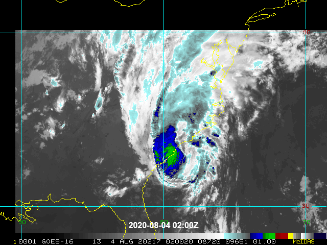
Satellite Loop (infrared) of Isaias at Landfall (02-04 UTC August 4). Source: NOAA/NESDIS.
Following landfall, Isaias moved rapidly to the north-northeast across the Carolinas. Isaias was downgraded to a tropical storm at 3 AM EDT August 4, with maximum sustained winds of 70 mph. The storm continued to accelerate to the north-northeast through the Mid-Atlantic States, arriving in southeastern New York by 5 PM August 4. Isaias maintained strength as a strong tropical storm, with maximum sustained winds dropping only to 65 mph during this time. Isaias produced periods of excessive but brief rainfall with reports of both riverine and flash-flooding. Gusty winds were also reported over widespread areas along with at least twenty tornado reports from the Carolinas to New England. The active tornado threat was enabled by changing wind speed and direction with height on the forward flank of the storm, especially on the right-front quadrant.
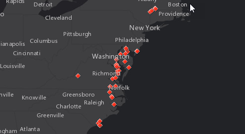
Tornado Reports August 1-4. Source: NOAA/SPC, GC AdvantagePoint.
As the storm continued to race into the Canadian Saint Lawrence Valley, it weakened and began to change into a post-tropical cyclone (frontal system). The NHC reclassified Isaias as a post-tropical cyclone, with equivalent tropical-storm-force winds of 45 mph, at 11 PM EDT August 4, just north of the New Hampshire/Québec border. The storm continued to weaken as it progressed from the Saint Lawrence Valley into central Québec, according to the final advisory of the NHC at 5 AM EDT August 5. The last tropical storm warnings were cancelled by the NHC for portions of Massachusetts and Maine, at 2 AM EDT August 5.
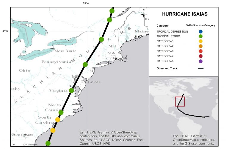
Hurricane Isaias Track and Intensity Reports from Landfall to the Canadian Saint Lawrence Valley. Source: NOAA/NHC.
Impacts
Hurricane Isaias produced impacts in the Caribbean and along the U.S. Atlantic Coast that were primarily wind-related, although with some coastal flooding due to storm surge, and locally severe inland flooding from heavy rainfall. Reports of downed trees and powerlines were widespread along with variable property damage due to wind, especially for those structures affected by significant tornadoes. At least 3.7 million customers lost power across multiple states, according to media reports.
Some light impacts due to wind and heavy rainfall were reported in Georgia and Florida. Impacts from the Carolinas to the Northeast became more severe due to significant tornado activity and strong winds. Seawater inundation due to storm surge affected portions of the immediate coast and adjacent waterways. Impacts across New York, Connecticut, and Massachusetts were primarily related to hazardous winds along with some localized flood impacts. It will take time to assess the full scope and severity of impacts as damage assessment and recovery efforts continue.
Caribbean
The Bahamas, Hispaniola, and Puerto Rico were the most impacted areas of the Caribbean. Hurricane Dorian caused significant damage to portions of the Bahamas in 2019, where they are rebuilding and in lockdown from COVID-19. The storm produced only limited damage reports across the Bahamian islands, due to winds and heavy rainfall. Prior to the storm, Bahamas Power and Light shut down electric power to areas at risk of flooding on the most populous island of New Providence.
Further south, damage due to flooding was most common in the Dominican Republic and southern Puerto Rico. The Dominican Republic Emergency Operations Center reported at least 1,100 homes damaged. West of Santo Domingo damage to 23 aqueducts led to disruption of water service to more than 335,000 people, and reports of power disruption to more than 72,000 people. Portions of Puerto Rico also suffered power outages, with estimates in the hundreds of thousands of people affected as well as 150,000 customers with no water service. The storm also produced rainfall-induced landslides in the southern portions of the island, according to media reports.
South Carolina
According to media reports, Horry County, South Carolina experienced localized property damage due to wind and flooding. A section of North Myrtle Beach’s Se Cabin Pier also collapsed.
North Carolina
In North Carolina, reports of damage due to wind and storm surge were concentrated along the coast from Ocean Isle Beach up to Wilmington. Storm surge, structural fires and tornado reports were found in Brunswick, Pender and Onslow Counties. The coastal areas along Oak Island, Ocean Isle Beach, and Southport reported storm surge impacts and seawater inundation of up to three feet along with structural fires in the Ocean Isle Beach area. Oak Island saw considerable sand intrusion from seawater inundation, with some localized wind impacts. In Southport, significant damage to the marina caused its closure and the Southport Baptist Church lost its steeple. Meanwhile a ferry connecting Fort Fisher and Southport was not operating due to damage to the docks.
Several tornado reports in North Carolina were attributed to damage: one in Bertie County, one in Hertford County, and a third on Bald Head Island in Brunswick County. A mobile home park was severely impacted in Windsor (Bertie County) where two people were killed, caused by a rare EF-3 tornado. Only 43 tornadoes of EF-3 or higher have been reported since 1950 with landfalling tropical cyclones. While tornado impacts were locally severe, most other damage due to wind was otherwise relatively minor. Power outages peaked at 370,000 customers across North Carolina, and by Wednesday morning 45,000 still were without power, according to media reports.
Virginia
In Virginia, the façade of the First Baptist Church in Norfolk collapsed, according to media reports. Major damage was also reported to affected structures in Southampton due to apparent tornado activity, according to reports of the National Weather Service. Possible tornado activity severely damaged several homes near White Stone on the Chesapeake Bay, causing at least two injuries. Reports also indicate multiple homes and businesses and one fire station damaged by a possible tornado in downtown Suffolk. Meanwhile the Palm Tree Inn in Courtland sustained major damage.
Maryland
In Maryland, two homes were removed from their foundations in Wicomico County on the coast. Three buildings also lost their roof, including one condominium, in Ocean City. A tornado was reported by the NWS in Mardela Springs along with major property damage. Tornado reports were also found in Calvert and Saint Mary’s Counties.
In addition to wind, considerable flooding was reported in Saint Mary’s County where most roads were impassable due to floodwaters. Water rescues were also necessary on a bridge near the border of Charles and Prince George Counties. Flooding and downed trees closed more than 60 roads in Anne Arundel County. The Chesapeake Bay Bridge was also closed for about three hours Tuesday morning due to high winds, according to media reports.
Delaware
For the State of Delaware, some homes and businesses sustained damage from a reported tornado in Dover. A wind gust to 96 mph in Smyrna, DE was also associated with an apparent tornado.
New Jersey
In New Jersey, a reported tornado affected portions of Cape May County in Marmora, where 6-12 structures were damaged. A church steeple was also lost in Ocean City. State offices remained closed on Tuesday. At least 1.4 million households were without power across the state.
Pennsylvania
In Pennsylvania, the Schuylkill River in Norristown crested early Wednesday at 20.5 feet, the fourth highest on record and not seen since Hurricane Floyd in 1999. Resulting floodwaters caused considerable inundation for portions of the Manayunk area where the river topped its banks, with significant business and residential effects. Further south on the river, an unsecured barge came to rest against a highway overpass in Philadelphia causing disruption to both road and regional rail traffic. Meanwhile significant flooding was also reported along portions of Darby Creek. Downed trees and powerlines along with pockets of structural damage and street flooding were also reported in Philadelphia and nearby counties. In Doylestown, four children were injured after the roof was removed from a day care center due to high winds. Meanwhile in the Upper Saucon Township, a vehicle was swept away in floodwaters causing one fatality.
New York
The Staten Island Ferry service and outdoor subway lines were shut down in New York City. The New York City power utility reported the number of power outages from Isaias is now second to those of Sandy (2012). More than 360,000 customers on Long Island and the Rockaways were without power, with 870,000 outages statewide. Meanwhile localized flooding was reported in Albany.
Connecticut
There were widespread power outages across most communities in Connecticut; the peak disruption was to approximately 720,000 homes and businesses according to media reports. Some towns declared states of emergency, like Greenwich, to address pervasive treefall where peak wind gusts measured 68 mph.
Massachusetts
Media reports indicate strong winds in Massachusetts produced downed trees and damage to power distribution lines, disrupting power to more than 220,000 customers.
Canada
As Isaias pushed into Canada, significant rainfall was reported in northeastern Ontario and northwestern Québec. Downtown Montreal recorded 45 mm in rainfall with other communities like Charlevoix and Trois-Rivières reporting more than 100 mm. Power outages in Québec City and surrounding region affected at least 46,000 customers of Hydro-Québec.
Sources: Reuters, Associated Press, The Weather Channel, The Weather Network, BBC, National Hurricane Center, National Weather Service, Storm Prediction Center, 6abc.com, The Hartford Courant, The Boston Globe, abc7ny.com, Agence France Presse.