
Severe thunderstorm activity in recent days has rendered considerable impacts from the Northern Plains through the Lower Great Lakes and Southeast. In particular, a significant derecho affected areas from Iowa through the Mississippi Valley and Lower Great Lakes on August 10, with concentrated reports of damaging wind gusts in excess of 75 mph. The storms produced downed trees and powerlines with resulting power outages over affected areas, along with considerable property damage. Significant vehicle damage has also been reported. The thunderstorm activity also produced reports of hail and tornadoes.
Physical Discussion
The thunderstorm activity of recent days was enabled by very unstable, warm, moist air with ample wind shear between a strong subtropical ridge to the south and a large upper-level low to the north. A complex surface front was associated with these features. Thunderstorm activity initiated in this environment over the weekend prior to August 10, with reports of damaging wind gusts, hail and some tornadoes over the Upper Midwest. One EF-2 tornado was also reported by the Meteorological Service of Canada over Scarth, Manitoba the evening of August 7.

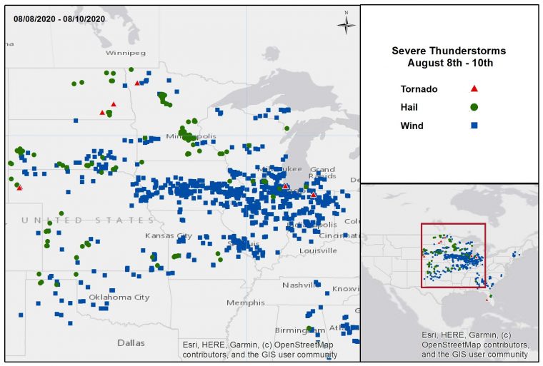
Severe Thunderstorm Reports August 8-10. Note clustered wind reports from Nebraska to the Lower Great Lakes. Source: NOAA/SPC.
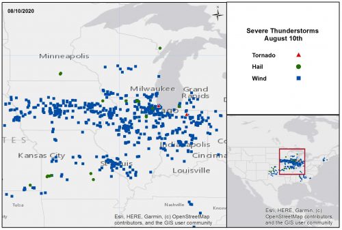
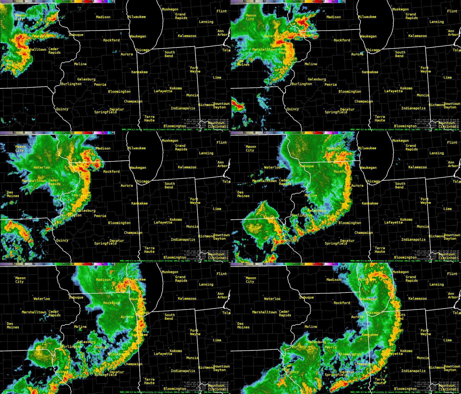
On Monday, August 10, a potent disturbance initiated thunderstorm activity over the Plains. This thunderstorm activity rapidly organized into a line of very strong thunderstorms moving through Iowa mid-day on Monday, August 10, and progressed eastward through several Midwestern states. The thunderstorms produced widespread severe wind gusts and damage over a long distance, with a few embedded tornadoes and hail reports. Wind gusts were reported by the U.S. Storm Prediction Center (SPC) well in excess of 75 mph, with a few isolated reports even exceeding 100 mph. The U.S. National Weather Service has identified this as a derecho event.

Radar Composite Loop August 10. Derecho is evident from the very wide bowing segment indicated by radar. Source: NOAA/NWS.
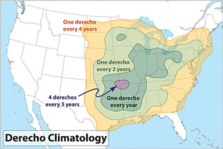
A derecho is a rare and prolonged severe weather event that typically produces a line of thunderstorms and concentrated severe wind gusts in excess of 58 mph, over a minimum distance of 250 miles according to the SPC. The effects can be up to 60 miles wide. Wind speeds in a derecho can exceed 100 mph, which can render damage similar to an EF-1 tornado, but over much broader areas. Derechos develop in an environment with very warm and moist air at the surface, colder air aloft, and moderate to strong winds at upper levels of the atmosphere. This environment is particularly common in the corridor from Iowa to northern Illinois and northern Indiana, where derechos occur approximately once per year.

Derecho Climatology for the Continental U.S. Source: CSU/NOAA.
Impacts
One fatality has been confirmed as a result of the derecho, with another two reported with the EF-2 tornado in Manitoba. In addition, several injuries were reported by media across multiple states. Damage surveys following the outbreak are still ongoing, but significant damage has been reported throughout portions of the Midwest, especially in Iowa and Illinois. Downed trees and powerlines were also reported throughout the Midwest. Over 600 reports of wind gusts in excess of 58 mph, or wind damage, were reported along the length of the derecho. More than one million customers were still without electricity as of Tuesday morning, with the majority in Illinois and Iowa.
Iowa
Severe impacts have been reported across much of Iowa, especially along the I-80 corridor. Several people trapped in buildings and cars were injured. Numerous social media reports indicated overturned vehicles, including tractor-trailers, causing road closures and traffic delays along Interstates 35 and 680. Structural damage was significant and widespread across the state, including roof and siding damage to homes and businesses in Cedar Rapids and Des Moines, where damage was sustained to the roof of the Buccaneer Arena, home of the United States Hockey League Des Moines Buccaneers. Building damage was also reported in Newton. A notable grain elevator in Luther was destroyed. Meanwhile in Perry, an airborne 2x4 punctured a home. Over 100 cars had their windows blown out in Marshalltown, Iowa, where an official wind gust of 99 mph was reported at the airport. Extensive tree damage across the Iowa State University campus in Ames was also reported, with estimated winds between 65 and 75 mph. Reports indicate that the storm path moved over roughly 20 percent of where Iowa corn is grown. Significant agriculture affects resulted, including damage to crops, equipment, and facilities throughout much of the state. Winds flattened corn and soybean fields north of Ames, with severe consequences for the crops. A number of grain storage and farm cooperatives across the state reported serious damage to storage bins and other infrastructure, in some cases rendering locations inoperable for the fall harvest.
Illinois
Throughout Illinois, “pockets” of damage, as referred to by the National Weather Service, were scattered about much of the northern part of the state. Downed trees, debris, and powerlines blocked roadways in parts of McHenry and Lake Counties. At least 150 power poles were damaged in Rockford, according to the fire chief. Downed power lines produced numerous fires in the city of Chicago, according to the Chicago Fire Department. Widespread damage was reported in La Salle and Bureau counties, and two mobile home parks in Forreston were severely impacted. One apparent tornado confirmed by video was reported in Rogers Park, a north-side neighborhood of Chicago, marking the first tornado in the city of Chicago in almost two years. The tornado became a waterspout as it moved over Lake Michigan.
Indiana
Damage extended east into Indiana where in Fort Wayne, two residents were trapped in a mobile home after it rolled over, ultimately with one death. A wind gust over 70 mph was reported in Russiaville, and significant tree damage was reported across the state. A tractor-trailer was blown over in Valparaiso.
Nebraska
In Nebraska, where storms originated Monday morning, heavy rain and strong straight line winds impacted the metro areas of Lincoln and Omaha. Heavy damage was reported in Omaha as streets and yards were occupied by downed trees and debris.
Wisconsin
An estimated wind gust of 70 mph was reported in Paddock Lake, Wisconsin, and structural damage, including a destroyed shed, was reported further west in Lancaster, Wisconsin.
Manitoba
Severe thunderstorms last Friday evening affected southern Manitoba including the Regional Municipality of Pipestone. One EF-2 tornado was confirmed by the Meteorological Service of Canada in Scarth, causing two fatalities and damage to farm buildings in the area, along with downed trees and powerlines.
Sources: Reuters, Associated Press, The Weather Channel, The Weather Network, Meteorological Service of Canada, U.S. National Weather Service, U.S. Storm Prediction Center.