
Two hurricanes threaten the Caribbean and northern Gulf Coast. Tropical Storm Marco should reach hurricane status shortly, and make landfall over southwest Louisiana Monday afternoon as a category-1 hurricane. In the meantime Tropical Storm Laura should clear Hispaniola today and cross Cuba tomorrow. Once Laura moves into the Gulf of Mexico, it should gain strength over unusually warm waters. Laura should make landfall as a category-2 hurricane over western Louisiana very early Thursday morning. Heavy rainfall, storm surge and damaging winds will bring amplified impacts from the two storms. Key aspects of this active threat follow below:
- TS Laura Overview
- TS Marco Overview
- Expert Discussion
- Impact Discussion

NHC Watches, Warnings, Track Forecast and Earliest Arrival Time of TS Winds for TS Marco (left) and TS Laura (right). Source: NOAA/NHC.

TS Laura is remarkably well intact in terms of convection and organization, despite traveling across mountainous terrain in Hispaniola. The pinks in the center of the infrared satellite loop below represent cloud tops in the -80 to -90 degree range, which indicates very deep convection; essentially rising air leading to strong thunderstorm activity and locally heavy rainfall. Hispaniola is a mountainous island and steep terrain forces air to rise, enhancing the precipitation potential. It is likely that Hispaniola is experiencing dangerous rainfall and associated perils with the passage of this storm. Once this storm emerges from land, the most likely place for it to establish a circulation center is where that deep convection is present along the southern edge of Hispaniola. This means a more southerly and westerly path than previous forecasts.

Satellite Loop (GOES16 Infrared) for TS Laura over Hispaniola Source: Tropical Tidbits.

Meanwhile, TS Marco is moving quickly to the north in the Gulf of Mexico, bordering on hurricane intensity. Infrared satellite imagery indicates very cold clouds tops but a smaller convective signature than TS Laura. While bursts of thunderstorm activity are occurring, an environment of significant shear is prohibiting the storm from gaining too much strength at the moment. The NHC expects a brief relaxation of the shear environment later today, which would allow TS Marco to take advantage of the warm Gulf water and attain hurricane strength. Much uncertainty remains in the ability of the storm to maintain this intensity in a marginal environment.
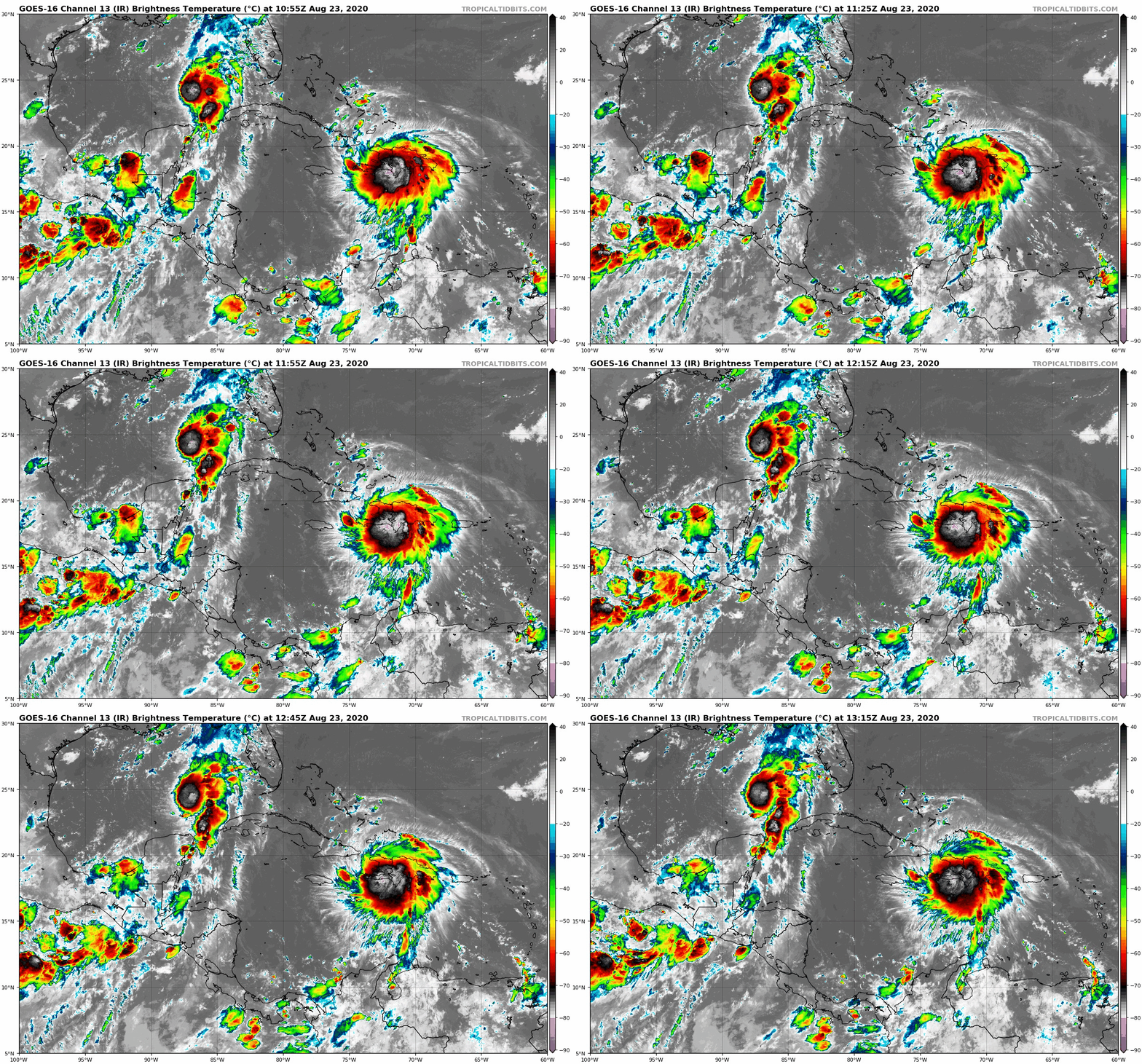
Satellite Loop (GOES16 Infrared) for Western Atlantic Basin. Source: Tropical Tidbits.
Expert Discussion
An unprecedented situation is unfolding in the Caribbean and the Gulf, with two named storms on an overlapping path toward the Gulf Coast States. While the current NHC forecast brings both storms onshore as hurricanes in Louisiana, the cone of uncertainty includes locations from south Texas to the Florida Panhandle. TS Marco is expected to very shortly strengthen to a hurricane in the Gulf, and make landfall within the next 24 hours, with Laura following about 36 hours later. The overlapping paths are interesting in that Laura will have to contend with upwelling cold water from the passage of Marco, which could possibly inhibit strengthening until Laura has once again tapped into the very warm waters west of the Marco path.
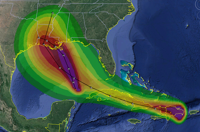
Tropical Storm Force Wind Speed Probabilities for Marco and Laura Source: Brian McNoldy Tropical Atlantic Update.
The GFS forecast model illustrates the timing and extent of both events well, as shown below. TS Marco is smaller and is expected to move quickly onshore as a Hurricane Monday evening. Meanwhile, TS Laura will be moving over Cuba prior to emerging into the Gulf just as TS Marco moves onshore. TS Laura will then have the opportunity to gain strength prior to a landfall that could be within miles of the landfall point of TS Marco. The Louisiana coastline is extremely vulnerable to perils associated with landfalling hurricanes, including wind, surge and rainfall. The land here is low lying and conducive to flooding. The category-2 windspeeds predicted for Laura could amplify the impacts in an area already fatigued from Marco.
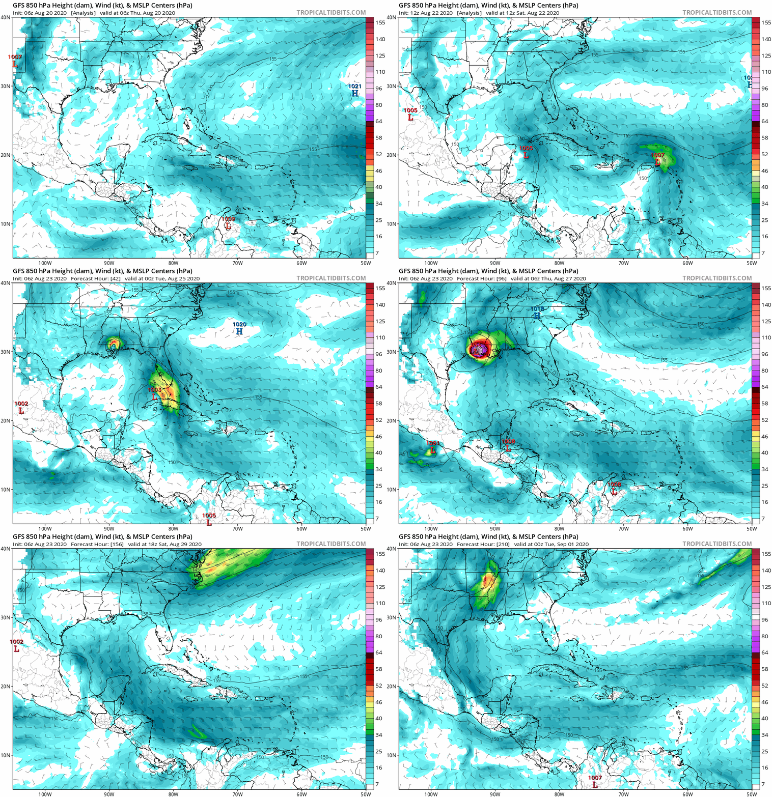
GFS Model Forecast Run for 00z Aug 23; illustrating the potential overlapping paths and landfall forecast for Marco and Laura . Source: Tropical Tidbits.
Impact Discussion
For Marco, current NHC forecasts indicate a maximum surge elevation of 4 to 6 feet along the coast from Morgan City, LA to Ocean Springs, MS with 2 to 4 feet of surge forecast for Lakes Pontchartrain and Maurepas. A storm surge warning has been issued for the coast from approximately Morgan City, LA to Biloxi, MS. Marco’s current forecast track roughly parallels the Mississippi River meaning surge impacts for Marco will largely be limited to the east of the river if the current forecast track is followed. The coastal geometry of this region to the east of the river is complex with numerous areas where surge can be amplified; In particular at the confluence the of Gulf Intercoastal Waterway and the Mississippi River Gulf Outlet at the western edge of Lake Borgne. The IHNC-Lake Borgne Surge Barrier is located in this region and will be closed for the duration of Marco and Laura to tentatively prevent surge from penetrating into the city of New Orleans from Lake Borgne.
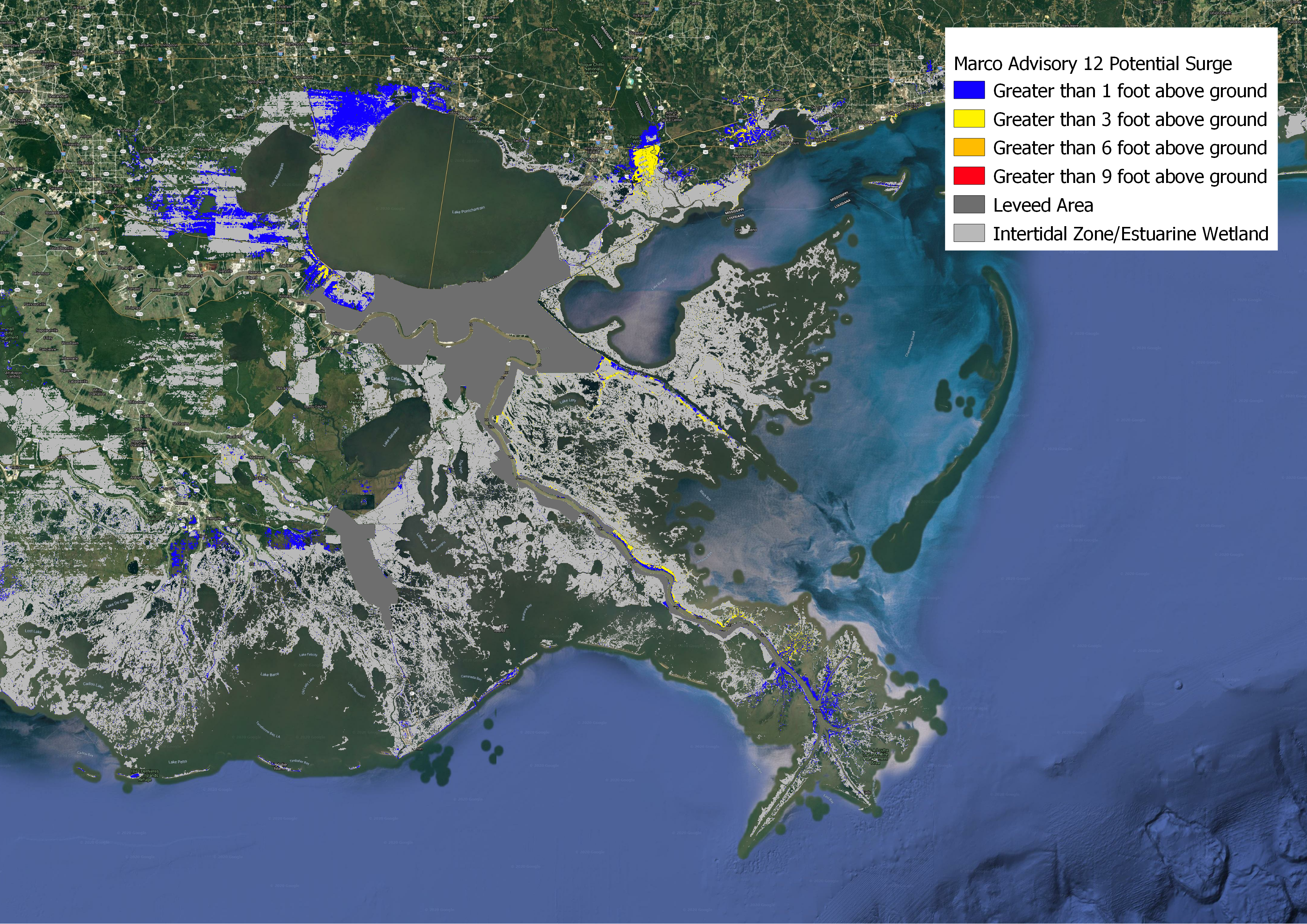
P-Surge forecast for TS Marco. Source: NOAA/NHC.
At this time surge impacts for Laura are less clear due to track uncertainties and complications from antecedent water levels due to Marco. Based on Laura’s current forecast track the Coastal Emergency Risks Assessment (CERA) Group forecasts 6 to 8 feet of surge in Terrebonne Bay just to the east of currently forecasted landfall; 4 to 6 feet in Barataria Bay just to the west of the Mississippi River; 6 to 8 feet in the Caernarvon Marsh on the east side of the Mississippi; 5 to 7 feet in Lake Borgne; and 4 to 6 feet in Lakes Pontchartrain and Maurepas. High uncertainty needs to be stressed regarding surge impacts from Laura due to current track forecast uncertainties and the effect Marco will have on water levels. Rainfall remains a serious concern. TS Marco is moving relatively quickly and expected to dissipate over the marshes of Louisiana, which should reduce the rainfall potential somewhat.
There are still many uncertainties when it comes to the ultimate path, size, strength and speed of TS Laura. Slower moving storms have the potential to be major rainmakers, so a close eye will kept on the speed at which Laura makes landfall. The physical footprint of Laura is also expected to be larger, therefore potential rainfall impacts will be spread over a larger area. Areas that were flooded from TS Marco will be extremely vulnerable to additional rainfall from TS Laura.
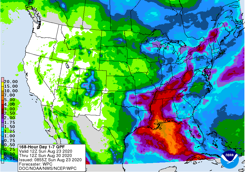
7 Day Rainfall Total Map Source: NOAA/WPC.
In the meantime wind impacts from Marco's passage as a category-1 hurricane will cause downed trees and powerlines along with some property damage due to wind. Heavy rainfall will loosen soil to amplify tree impacts in the affected area. When Laura passes as a category-2 hurricane, over a similar area, wind impacts could well be amplified due to fatigue from Marco's earlier passage, especially along and to the right of the core of the storm.
Updates and Useful Links
Email alerts for Weather Sentinel and CAT-i reports are available on a subscription basis at the GC Preference Center here.
Daily, global tropical cyclone alerts are also available on a subscription basis here.
U.S. National Hurricane Center
American Meteorological Society COVID-19 & Hurricane Evacuation Guidance
Official statements from the NHC and U.S. National Weather Service, and those of emergency management agencies supersede this update, and should be closely monitored concerning matters of personal safety.