

Isaias has likely reached peak intensity Saturday morning over the central Bahamas. Thereafter, Isaias will track very close to the Florida coastline through Sunday before moving inland in the Carolinas late Monday, likely as a tropical storm. Risk is lower today than yesterday for the US coastline.
Bahamas: Most of the island country has seen tropical storm force winds through Saturday morning with peak storm surge heights of 2-4 feet.
Florida: Isaias will hug the coastline with a 15% chance of sustained hurricane force winds in coastal cities. Precautionary hurricane warnings are posted from Boca Raton north to Volusia County, FL.
Southeast US: A weakening Isaias will now bring tropical storm conditions to the region late Sunday through Tuesday morning.
Mid-Atlantic/Northeast: Risk has meaningfully decreased north of the Carolinas. Main impacts are to be an 18-24 hour period of moderate to heavy rainfall and blustery conditions mid-week.
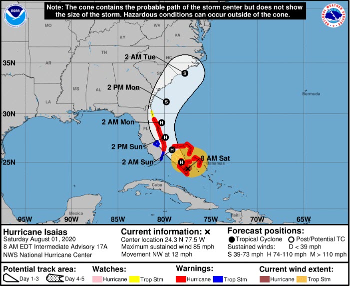
Hurricane Isaias Position, Windfield, Watches/Warnings and 3-Day Forecast.
Source: NHC.
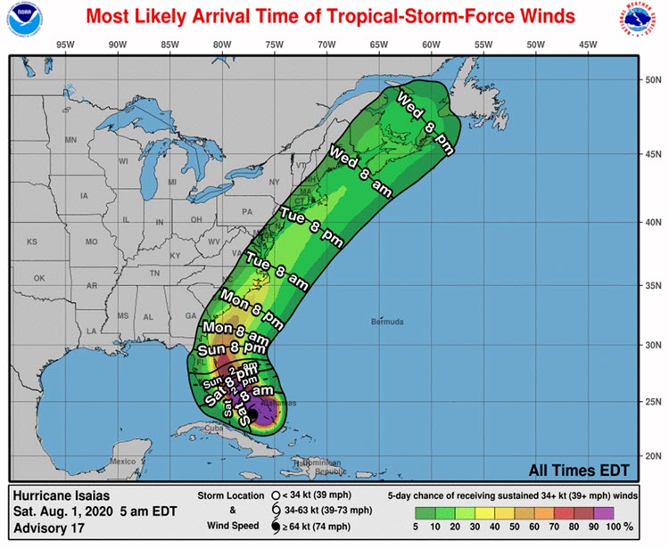
Most Likely Arrival Time and Probability of Tropical Storm Force Winds.
Source: NHC.
After intensifying more rapidly than anticipated yesterday, overnight Isaias started to feel the influence of deteriorating factors including increasing southwest windshear and dry air at the mid-levels of the atmosphere. As a result, the appearance of Isaias in both radar and satellite has become less organized since Friday evening.
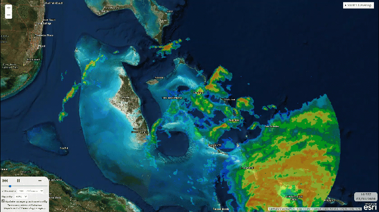
Radar Animation of Hurricane Isaias. Source: Bahamas Department of Meteorology.
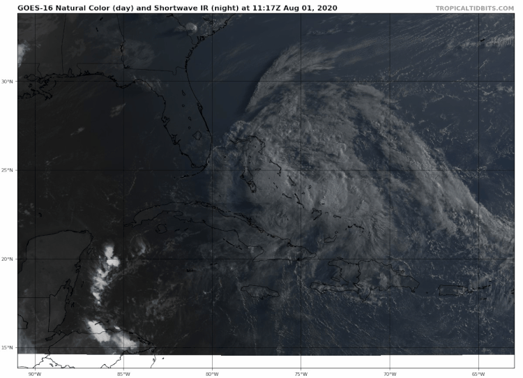
Satellite animation of Hurricane Isaias illustrating increasingly disorganized structure.
Source: tropicaltidbits.com.
Florida projections
NHC issued hurricane warnings at 5PM Friday afternoon for the majority of the eastern Florida coastline north of Boca Raton, FL. As of Saturday morning, no evacuation warnings have been issued. Moreover, latest NHC probabilities of any coastal Florida city seeing sustained hurricane force winds are below 10%. While portions of eastern Florida will likely see wind gusts in excess of tropical storm strength, the latest depiction of coastal locations ultimately seeing hurricane force winds is a conservation assessment based on actual probabilities.
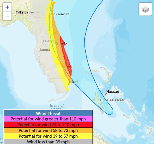
Latest NHC forecast combined with peak wind expectations for Florida. Note the coastal area from Boca Raton to Cape Canaveral threatened to see winds of 74 to 110 mph is an actual probability of less than 10% of occurring.
Source: NWS/Southern Region.
With Isaias tracking parallel to the Florida coastline, storm surge height forecasts are less than three feet. Further north into the Southeastern US, due to the coastline configuration relative to the forecast track of Isaias, there is a small probability that storm surge could exceed three feet in isolated portions of the coast, namely near Savannah, GA and Charleston, SC.
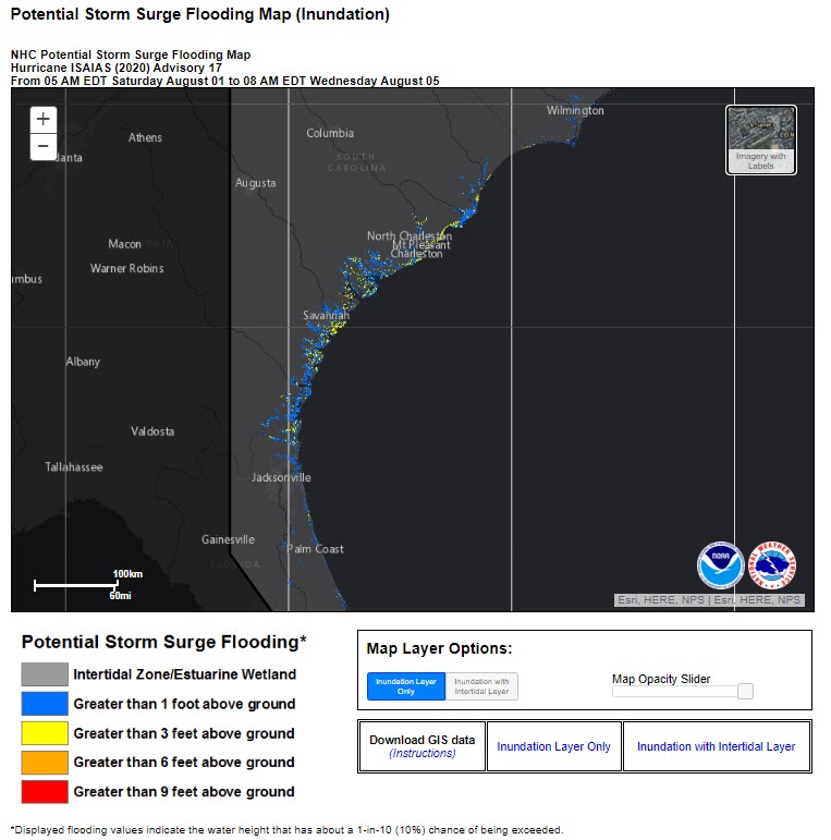
National Hurricane Center Possible Storm Surge Inundation (10% chance of levels being exceeded).
Source: NHC.
North of Florida The primary issue for communities in the Southeast, Mid-Atlantic and Northeast US will be the potential for heavy to excessive rainfall over a 12 to 18 hour duration.
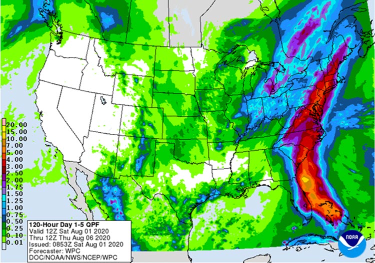
5-day rainfall total forecast through Thursday August 6. Source: NOAA/WPC.
Unless the forecast verifies to the stronger side of expectation, with sustained hurricane force wind speeds and a hurricane landfall along the US coastline, the next Weather Sentinel will be issued on Monday, August 3.
Updates and Useful Links
Email alerts for Weather Sentinel and CAT-i reports are available on a subscription basis at the GC Preference Center here.
Daily, global tropical cyclone alerts are also available on a subscription basis here.
U.S. National Hurricane Center
American Meteorological Society COVID-19 & Hurricane Evacuation Guidance
Official statements from the NHC and U.S. National Weather Service, and those of emergency management agencies supersede this update, and should be closely monitored concerning matters of personal safety.