

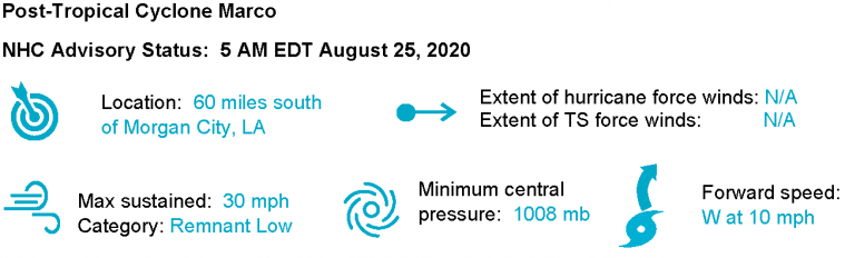
Laura now poses an escalating threat for landfall as a major hurricane near the Texas/Louisiana line. Expected impacts include severe wind damage, seawater inundation and inland flooding, with lighter wind impacts well inland. Marco is now a remnant low and should dissipate south of the coast later today.
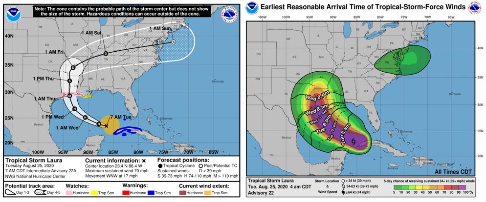
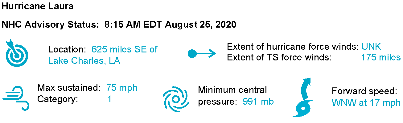
As of 8:15 am ET, Laura was upgraded to a category-1 hurricane by the National Hurricane Center. A hurricane hunter aircraft confirmed winds of 75 mph, with higher gusts. As predicted, once Laura moved past Cuba and entered the warm Gulf of Mexico waters, intensification occurred. Satellite imagery shows a much more organized storm, with a ragged eye beginning to form. The Morphed Integrated Microwave Imagery at CIMSS (MIMIC) product below provides a radar-like visualization of the evolution of hurricane structure. As the storm is pictured moving off the western tip of Cuba, a band of convection to the north is visible, showing a nearly formed round eyewall. Laura is moving over warm water in a very low shear environment. The NHC forecasts intensification to a category-3 hurricane prior to landfall along the TX / LA coast.
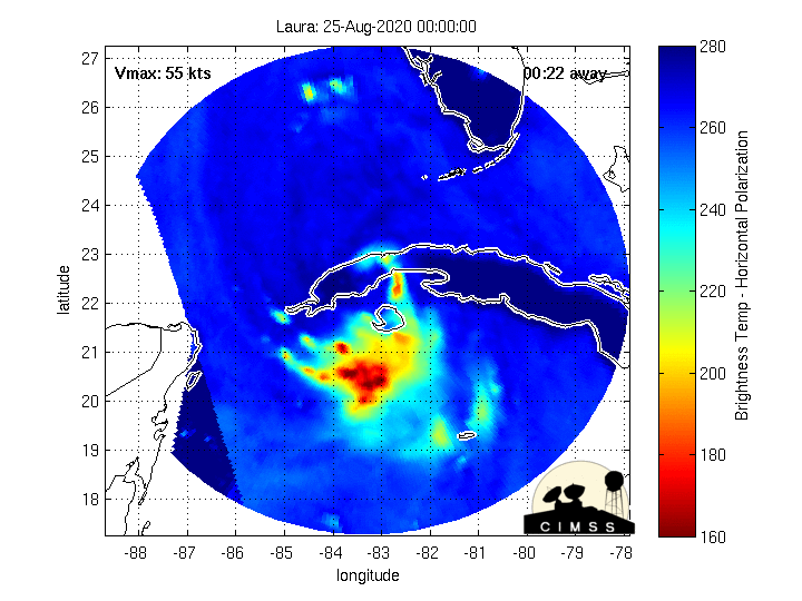
Morphed Integrated Microwave Imagery. Source: CIMSS. In the meantime Marco made landfall around 7PM EDT last night as a tropical storm, near the mouth of the Mississippi River. Gusty winds and some heavy rain affected the northern Gulf states as Marco moved near or over the coast. Marco has since weakened to a remnant low and should dissipate later today offshore of the Louisiana coast.
Expert Discussion
Vertical wind shear is one of the most important ingredients in hurricane formation or dissipation. Vertical wind shear is the change in direction and speed of winds at increasing heights in the atmosphere. When strong vertical wind shear is present, the hurricane becomes "sheared". What this essentially means is that the upper and lower portions of the storm get separated and circulation gets disrupted. TS Marco was a good example of other ingredients being present, but with strong vertical wind shear the storm could not intensify. Laura has also battled moderate amounts of shear, however the hurricane is moving into an area of low (represented by blue shading) vertical wind shear in the central Gulf, and the tendency (represented by dashed blue lines) has been for it to decrease further over the past 24 hours.
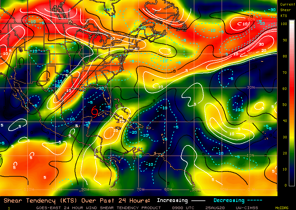
Wind shear tendency. Source: CIMSS
In addition to a favorable shear environment, the sea surface temperatures are anomalously warm. Temperatures in the central to western Gulf are averaging 30-32 degrees C; which is 1 to 2 degrees warmer than normal. The only cold spot in the Gulf is where Marco came onshore and caused upwelling. Laura is forecast to track over these warm waters, which in combination with low shear could fuel a period of rapid intensification later today.
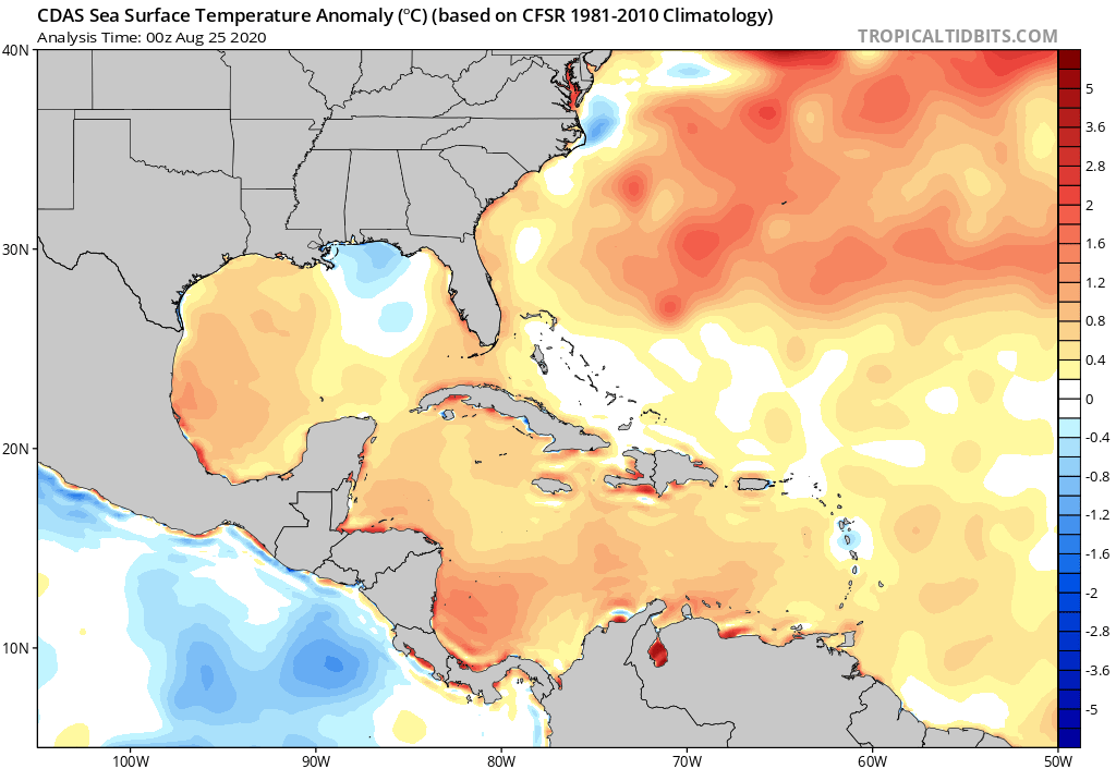
Sea Surface Temperature Anomaly for Western Atlantic. Source: Tropical Tidbits
The official NHC forecast calls for a category-3 landfall along the TX / LA coast, which is supported by forecast model consensus. Most models intensify Laura to a category 2 or 3 hurricane within 24-36 hours, although some models are more aggressive with intensification. Track consensus is tightly clustered, lending confidence to the forecast, although landfall possibilities still exist from the upper TX coast to New Orleans.
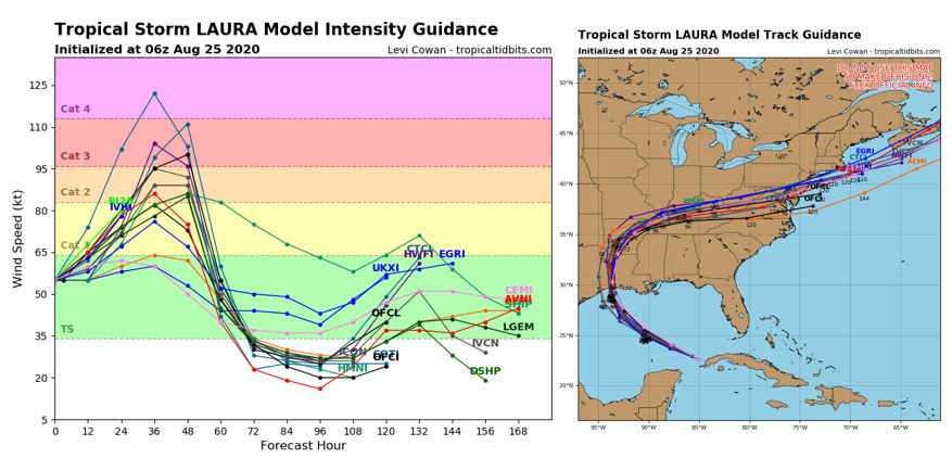
Model forecast plots for intensity (left) and track (right). Source: Tropical Tidbits
The current HWRF model run is one of the more aggressive models with intensity, forecasting a major hurricane landfall by early Thursday right on the border of TX and LA. The loop below shows the simulated composite radar reflectivity for the forecast, with intense winds imbedded in the deep convection of the eyewall at landfall. While models and NHC are coming into better agreement on the landfall location and intensity, there is still some uncertainty about where major impacts will be felt. Wind, rain and storm surge impacts will extend well beyond the landfall location.
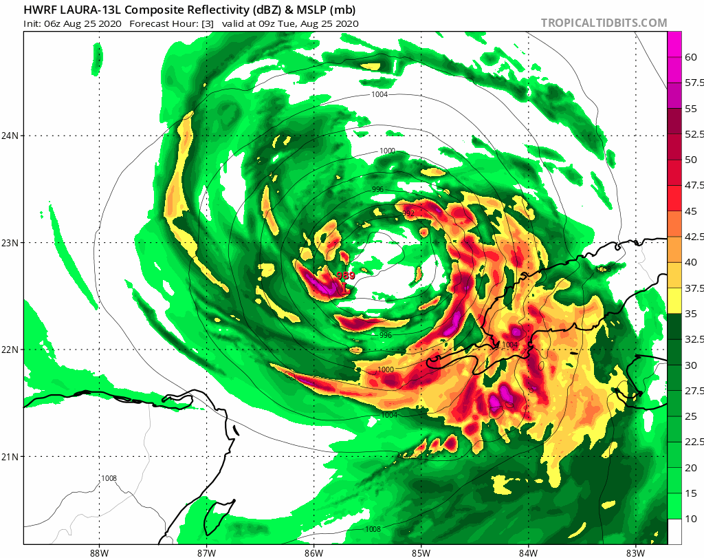
HWRF Model Composite Radar Reflectivity Forecast for landfalling Laura . Source: Tropical Tidbits
Laura Wind and Rainfall Impacts
As discussed above Laura is expected by the NHC to make landfall as a category-3 or higher hurricane. Wind impacts will be severe along and to the right of the core of the storm, especially for those areas near the coast. Extensive damage to property and infrastructure is probable for these areas. In the meantime given the growing footprint of the storm, downed trees and powerlines along with lighter wind impacts can be expected well away from the center of circulation, and for those areas well inland. Tornado activity may also become an active threat as the storm moves inland, to produce localized severe damage to affected property and infrastructure. Wind impacts may be amplified due to heavy rainfall from both Marco and Laura.
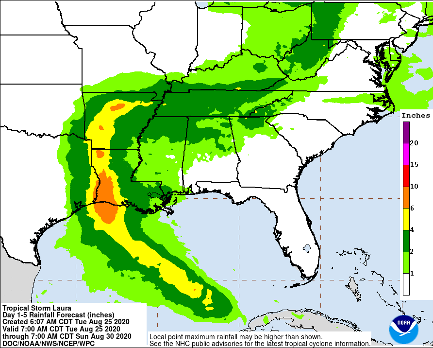
5-day rainfall map through 12 UTC Sunday. Source: NHC Heavy rainfall is also an increasing concern. Rainfall amounts of 4-8 inches, and isolated amounts to 12 inches are expected per the NHC. This will produce a threat for flooding and flash-flooding both along the coast and for areas well inland.
Detailed Storm Surge Discussion
Laura’s increased forecast intensity for prior to and at landfall has consequentially increased forecast surge across the coast and inland in the LA/TX border region. The NHC currently forecasts Laura’s peak surge to reach 7-11 feet and occur between High Island, Texas and Morgan City, Louisiana. 7-11 feet of surge is also possible in coastal water bodies in the region such as Sabine Lake, Calcasieu Lake, and Vermillion Bay. Peak surge in other areas include 4-6 feet from Port Bolivar to High Island on the Texas Coast and 4-6 feet from Morgan City, Louisiana to the mouth of the Mississippi. Peak surge from the mouth of the Mississippi River to Ocean Springs, Mississippi is forecast to be 3-5 feet. This region was impacted by 1-3 feet of surge by Tropical Storm Marco over the past several days and water levels remain high as water drains from the coastal swamps. These elevated antecedent water level from Marco will enhance surge levels driven by Laura.
The NHC Probabilistic Tropical Storm Surge (PSurge) product considers uncertainty in forecast track and intensity to provide exceedance probabilities of surge elevations. For Advisory 22 (0500 EDT August 25) PSurge indicates a 10 percent probability peak surge from Laura will 15-17 feet in the region of landfall and 50 percent probability peak surge will exceed 7 to 9 feet.
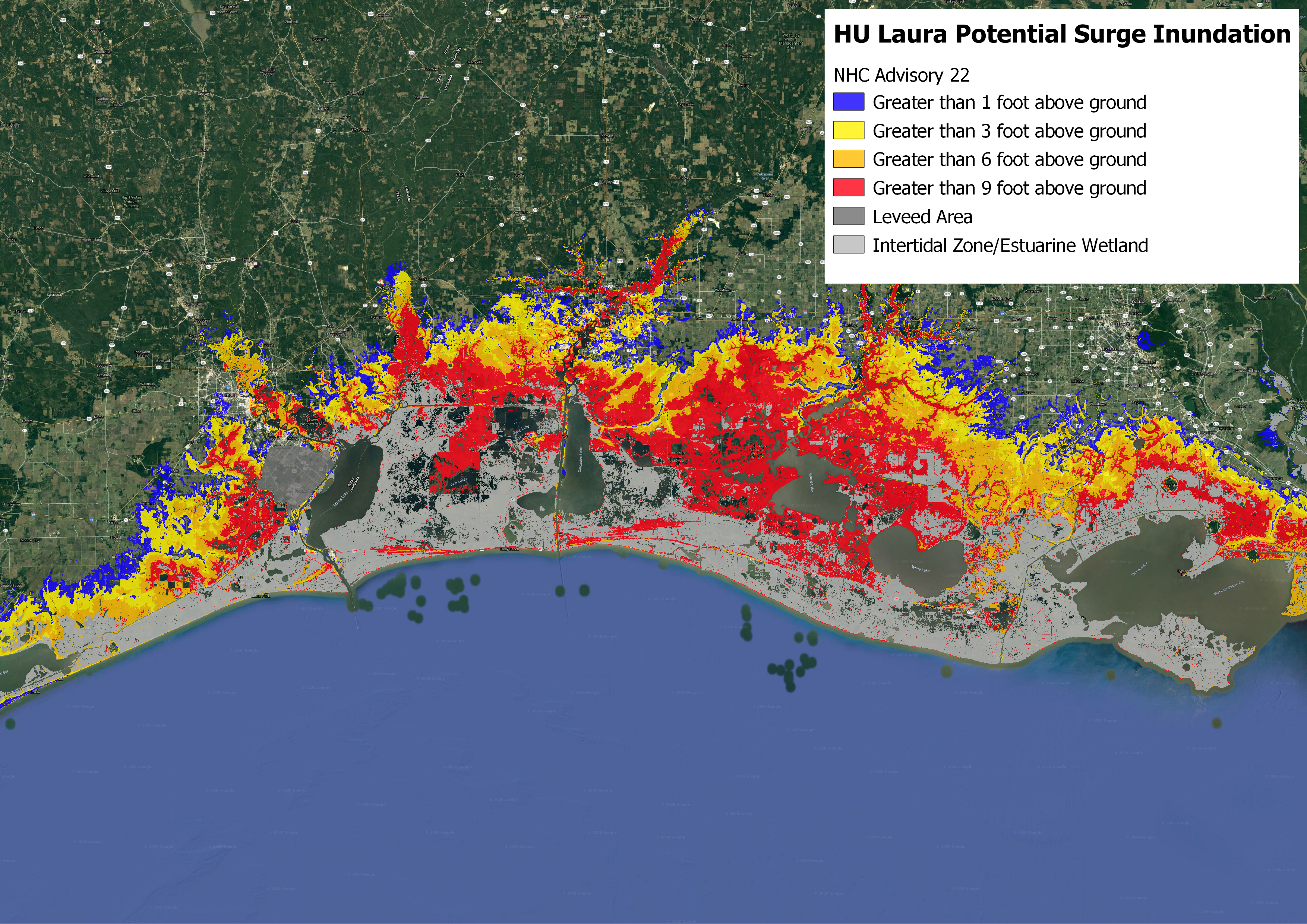
Potential Storm Surge Flooding for Hurricane Laura based on Advisory 22 (0500 EDT August 25). Potential Storm Surge Flooding does not depict the forecast surge inundation for an event, rather the 10 percent exceedance flood depth based on uncertainty in forecast track and intensity. Source: NHC
Based on NHC’s best track forecast as of Advisory 21 the Coastal Emergency Risks Assessment (CERA) group models maximum surge elevation from Laura to be 10 to 12 feet at the coast and slightly inland near Grand Chenier, Louisiana, just to the east of the forecast landfall location.
Laura is currently forecast to make landfall early in the morning on Thursday August 27 coinciding with high tide for the Louisiana-Texas border region. However, tidal range in the region is small compared to other coastal regions: the forecast high tide for early Thursday at Calcasieu Pass, Louisiana is approximately 1.05 feet above mean sea level near 1:30 AM local time.
A surge phenomenon that may be observed during Laura’s approach is a ‘forerunner surge’. A forerunner surge is generated when as a large storm approaches the coast an along-shore current is generated as winds are aligned with the shoreline while the hurricane is still offshore. Depending on the orientation of the coastline the shore parallel current may increase water levels along the coast before the onset of strong onshore winds. While forerunner surges are not devastating on their own they can increase coastal and inland water levels before shore parallel winds begin to push inland effectively enhancing peak surge. A forerunner surge of approximately 1 to 3 feet was observed during Hurricane Ike (2008) which also affected the Louisiana-Texas coast.
Historical Context
Laura shattered the record for the earliest named “L” storm in the known historical record by over a week, and if current forecasts hold as expected, Laura will be the 7th named storm and the 3rd hurricane to make landfall in the continental U.S. this year. Few seasons are comparable in terms of tropical activity; only twice since 1851 have at least 3 hurricanes made landfall by August 27 (1886 and 1916).
Laura is forecast to become the first major hurricane of 2020, and make landfall along the Gulf Coast at major hurricane strength. The last major hurricanes to do so in Texas and Louisiana were Hurricanes Harvey (2017) and Rita (2005), respectively. While Hurricane Harvey does not serve as an appropriate analog for Laura, numerous storms in the historical record have made landfall within the current cone of uncertainty. Two of these are discussed below:
- Hurricane Ike (2008), while much larger in size than Hurricane Laura, tracked on a similar path to Laura’s forecast. It ultimately made landfall along the western edge of Laura’s cone of uncertainty just east of Galveston, Texas as a category-2 Hurricane. Ike caused widespread, severe damage to the Galveston and Houston areas, including significant storm surge inundation for an area known to be prone to significant storm surge.
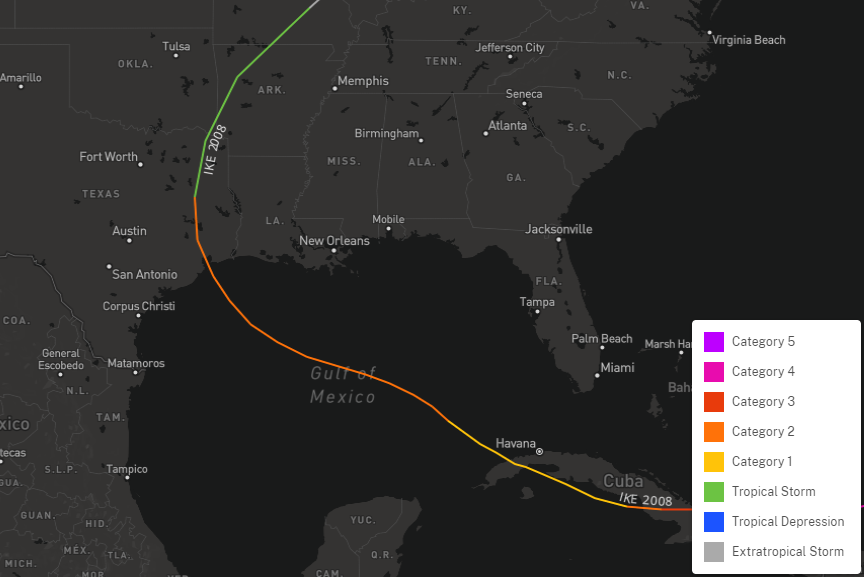
Hurricane Ike Track 2008 Source: NOAA [/caption]
- Hurricane Rita (2005), as referenced above, made landfall in 2005 just east of the TX/LA border, where Laura is currently forecast to make landfall later this week. While Rita moved north of Cuba and strengthened significantly into a category-5 hurricane in the Gulf of Mexico, Rita ultimately made landfall as a category-3. At peak strength, Rita was much stronger than Laura is forecast to be, just as Ike was much larger. Rita was responsible for significant wind damage to southwestern Louisiana, and ultimately spawned over 90 tornadoes in a 3 day period.
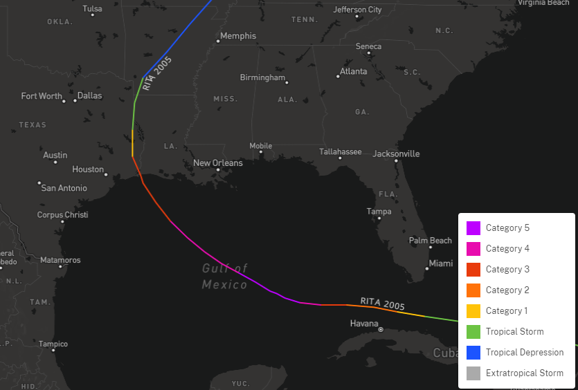
Hurricane Rita Track 2005 Source: NOAA
Some historical storms may have similar characteristics in terms of track, size, wind speed, landfall location, or other characteristics. However, no two storms are ever the same. While the track of Laura may appear similar to other known historical storms, the characteristics of size, intensity and lifecycle will be very different from these historical analogs.
Updates and Useful Links
Email alerts for Weather Sentinel and CAT-i reports are available on a subscription basis at the GC Preference Center here.
Daily, global tropical cyclone alerts are also available on a subscription basis here.
U.S. National Hurricane Center
American Meteorological Society COVID-19 & Hurricane Evacuation Guidance
Official statements from the NHC and U.S. National Weather Service, and those of emergency management agencies supersede this update, and should be closely monitored concerning matters of personal safety.