
Tropical Storm Marco is weakening and should follow the Louisiana coast tonight and dissipate Wednesday morning. Laura then poses a landfall threat for Texas/Louisiana for Thursday morning with at least category-2 strength. Hurricane winds, storm surge and heavy rainfall are hazards of concern.
Key aspects of this active threat follow below:
- TS Marco Overview
- TS Laura Overview
- Expert Discussion
- Impact Discussion
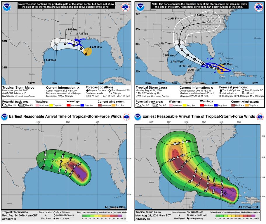
Warnings, Track Forecast and Earliest Arrival Time of TS Winds for TS Marco (left) and TS Laura (right). Source: NOAA/NHC.

TS Marco briefly strengthened to a category-1 Hurricane on Sunday afternoon, but weakened to a tropical storm after encountering considerable shear in the Gulf of Mexico. The shear is only forecast to increase as Marco nears the Louisiana coastline, which will discourage any chance of re-intensifying to a hurricane. TS Marco is being steered to the northwest in response to a low level ridge; with movement becoming more westerly in the next several hours. Model guidance is suggesting that TS Marco will graze the Louisiana coastline on a westward track before dissipating. The tropical storm is quite disorganized, and wind and rainfall impacts will not follow typical patterns of landfalling hurricanes. The expectation is that the heaviest rainfall may be northeast of the loosely defined center of circulation.
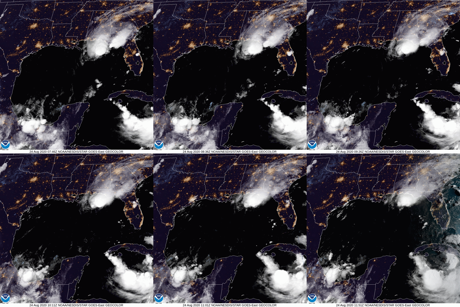
GOES East Geocolor satellite loop of Gulf of Mexico Source: NOAA/NESDIS.

TS Laura continues to retain organization as it begins a passage over Cuba. The radar image below illustrates precipitation intensity, with the oranges and reds representing heavier rain and thunderstorms. The storm is passing along southeast Cuba, where the Sierra Maestra mountains rise to 2000m in elevation. The satellite imagery clearly illustrates heavy convection associated with air being forced to rise along this mountain range, although the heaviest rain is currently remaining offshore with the circulation center. This more southerly track for TS Laura brings the storm center over warm open water just south of Cuba, rather than over land. Less land interaction and a greater ability to tap into ocean heat content will likely allow TS Laura to gradually strengthen over the next 24 hours before emerging into the Gulf on Tuesday morning. Once in the Gulf, TS Laura could see a period of rapid intensification.
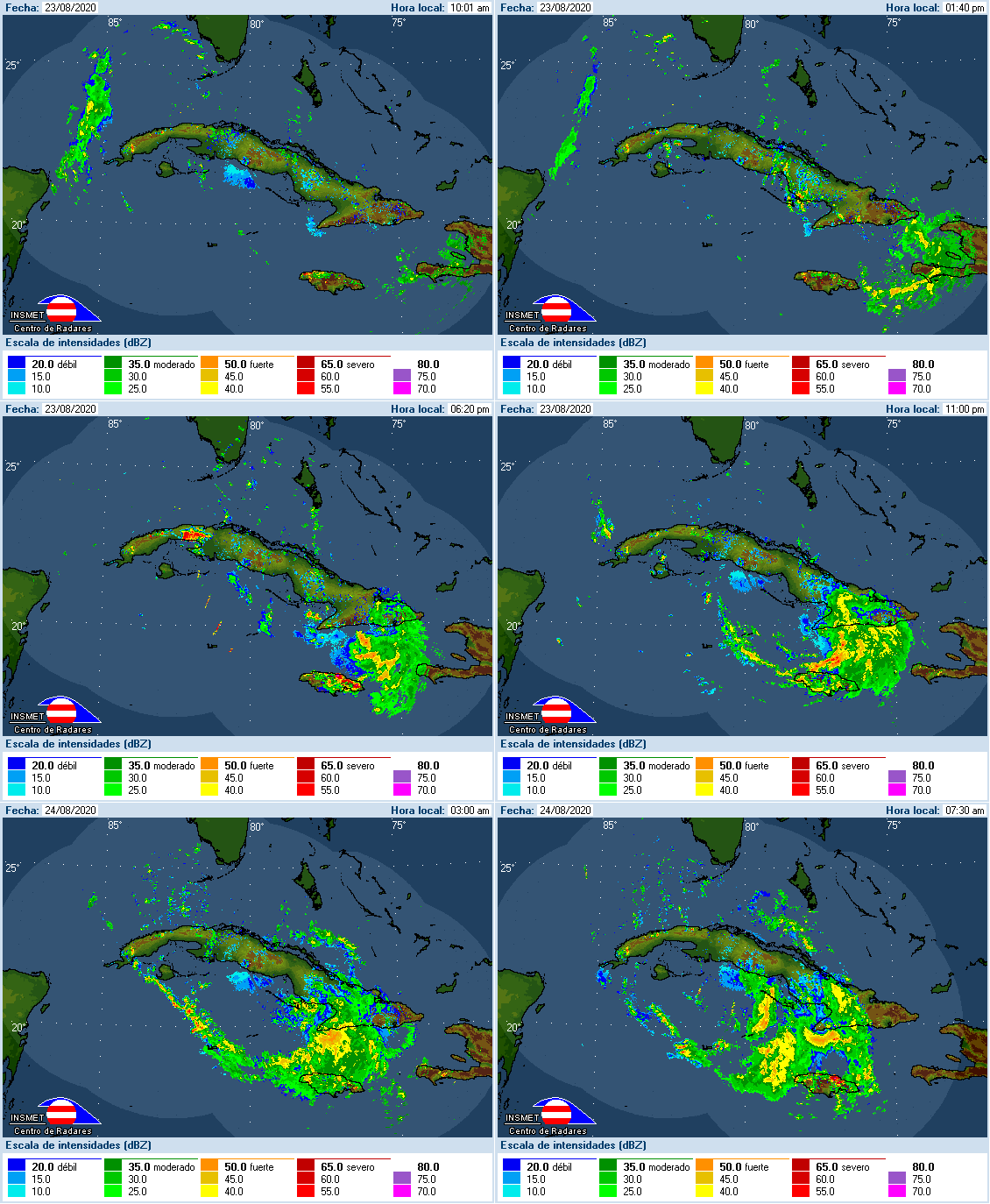
Radar loop of TS Laura passing over Cuba on Aug 24 Source: Instituto de Meteorologica, Inicio.
Expert Discussion
TS Laura continues to pose a forecasting challenge for the National Hurricane Center. The forecast path has consistently drifted south over the past several days; from a South Florida landfall to a TX/LA border landfall, as illustrated below with red being more recent forecasts. This track drift has caused complexities in the forecast in terms of the amount of land interaction that would possibly disrupt intensification, to the availability of heat from the ocean.
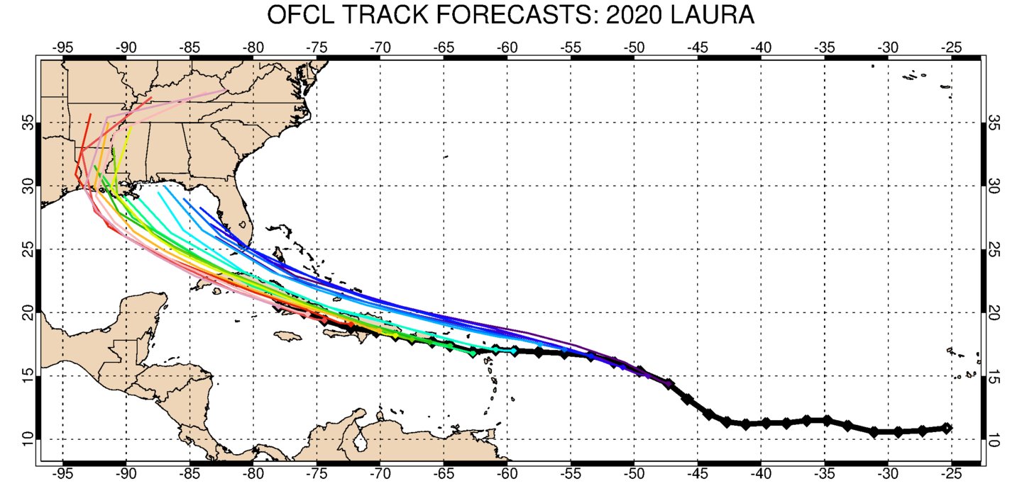
Official NHC track forecasts (Purple oldest, red newest) Source: Twitter @BMcNoldy.
The latest track guidance is fairly clustered on a west LA landfall, although outliers do exist that build the Bermuda high a bit stronger and push TS Laura further west into Texas. All forecast solutions keep TS Laura south of the island of Cuba, over open water, and tracking over the deep and very warm Gulf Stream and Loop Currents.
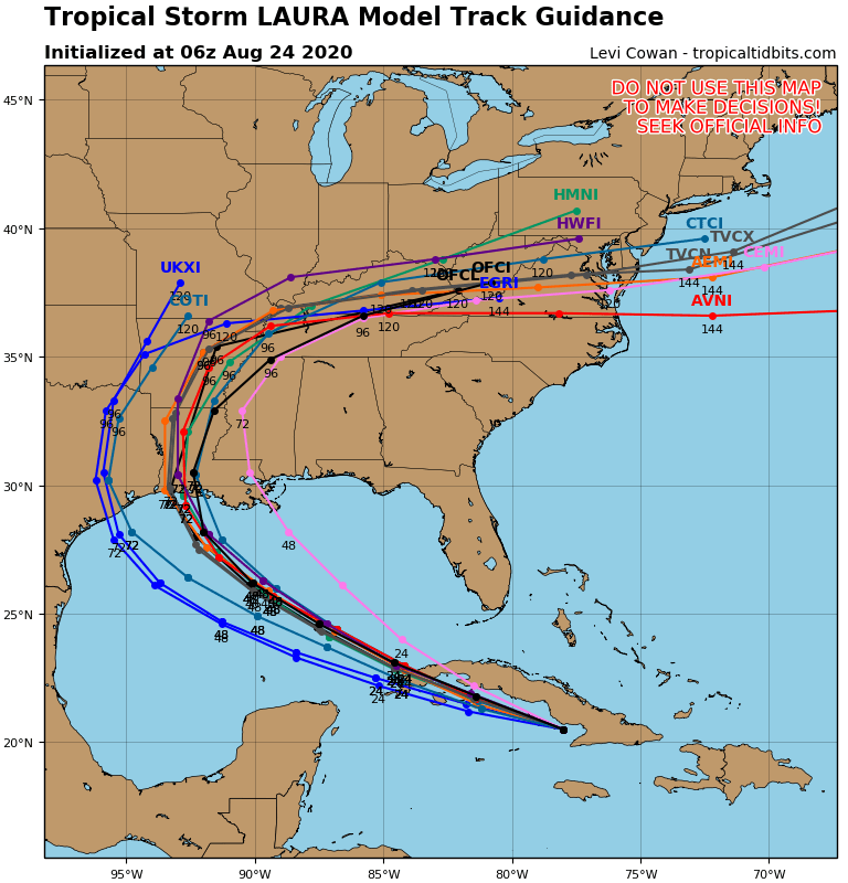
TS Laura Track Model Guidance. Source: Tropical Tidbits.
The exact path of TS Laura through the Caribbean and Gulf will have implications on intensification. Generally waters over 28 degrees C will be conducive to supporting a hurricane. Notably, the waters south of Cuba are upwards of 31 degrees. Water in the eastern Gulf is averaging around 30 degrees C, while the western Gulf has pockets of 32 degree C water. If the track for TS Laura continues to drift south and west, and the storm can tap into these very warm waters, intensification to a major hurricane is certainly possible, and could happen rapidly.
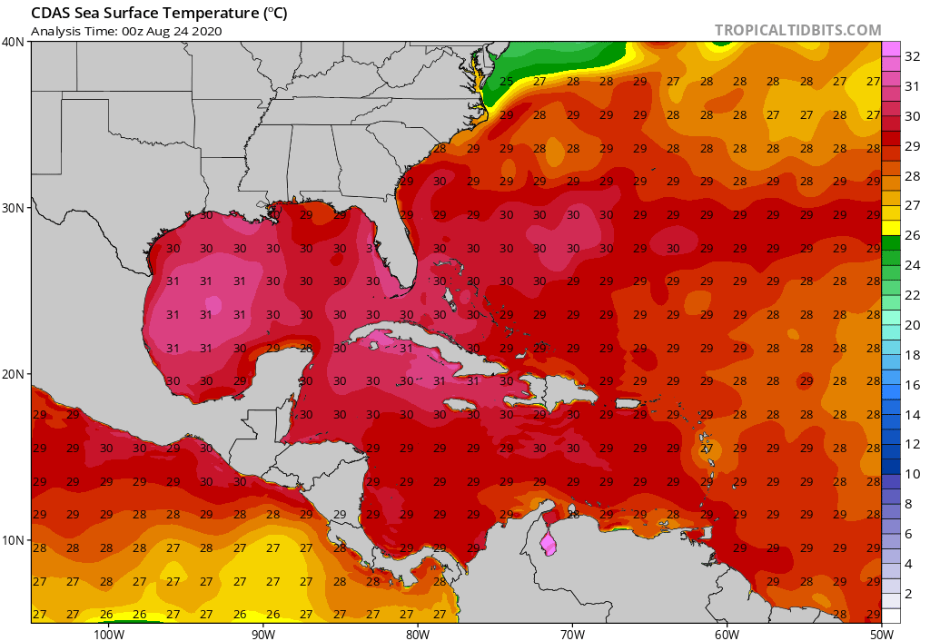
CDAS Sea Surface Temperature Source: Tropical Tidbits.
The HRWF and HMON models bring Laura to major hurricane strength by 60 hours. In contrast, statistical models and the ECMWF model keep TS Laura as a 75 knot category-1 hurricane. The official National Hurricane Center forecast hedges between the two solutions. Given the warm waters, low shear environment, and less land interaction, it is possible that TS Laura will intensify shortly.
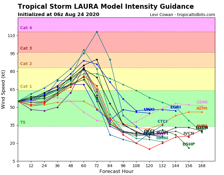
TS Laura Intensity Guidance Aug 24 06z. Source: Tropical Tidbits.
The official NHC forecast does not intensify TS Laura to a major hurricane prior to landfall, but as previously mentioned, several models do predict intensification. The two images below are simulated IR brightness temperatures from the HWRF model and the GFS model, respectively. Both predict a strong landfalling hurricane Laura by late Wednesday night, as illustrated by the very cold cloud tops in the simulated IR. There remains much uncertainty about the path, strength and size of TS Laura prior to a US Gulf Coast landfall.
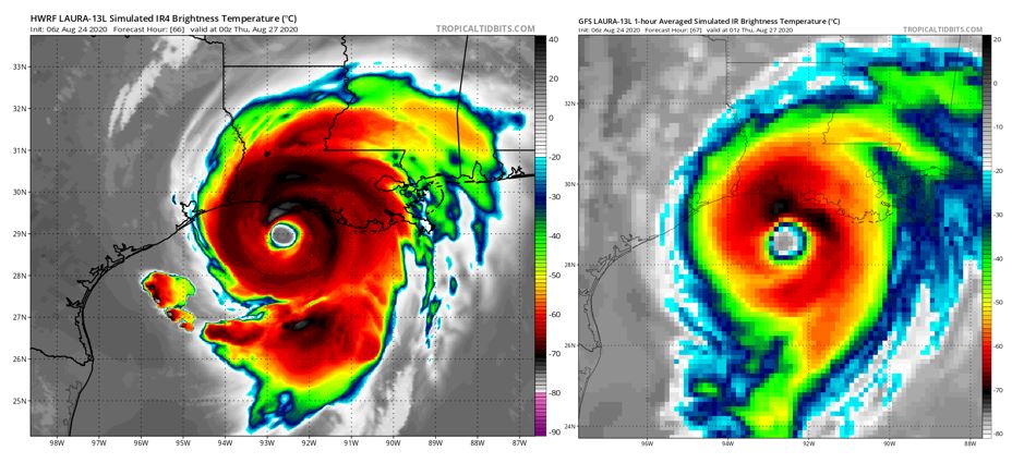
Simulated satellite (infrared) brightness temperatures from the HWRF model (left) and GFS model (right) Source: Tropical Tidbits.
Impact Discussion
Despite Tropical Storm Marco’s gradual weakening overnight, gusty winds and heavy rainfall have started to affect parts of the Northern Gulf Coast. Tropical storm conditions will begin to materialize along the Mississippi and Louisiana coastline today, with the potential for dangerous storm surge along the immediate coast.
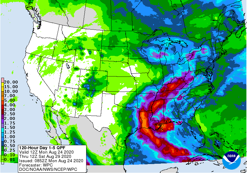
5 day quantitative precipitation forecast Source: NOAA/WPC.
Marco is forecast to produce 3 to 5 inches of rainfall across a widespread area of southeastern Louisiana along the coast to the Alabama/Florida border. Isolated amounts of up to 10 inches could be possible through Tuesday. Excessive rainfall could result in localized flash, urban, and small stream flooding across the area. Isolated tornadoes will be possible from southeast Louisiana to the western Florida Panhandle.
The shift in Marco’s forecast track and diminished forecast intensity over the past 24 hours has lessened forecasted surge impacts for the Louisiana coast. A Storm Surge Warning remains in place along the coast from Morgan City, Louisiana to Biloxi, Mississippi with peak surge elevations of 2 to 4 feet from Morgan City to Ocean Springs, MS and 2 to 4 feet of surge in Lake Borgne according to the NHC. Despite the slightly westward drift of Marco’s forecast track surge impacts are still largely forecast to be limited to east of the Mississippi River with maximum inundation occurring in the intertidal areas of the Caernarvon Marsh.
Heavy rainfall and fatigue from tropical storm force winds from Marco have the potential to amplify future impacts from Hurricane Laura. Tropical storm conditions are currently impacting Cuba and Jamaica and are expected throughout the Florida Keys later today as Laura moves generally to the west northwest. Once Laura clears land and moves into the Gulf of Mexico by Tuesday, the extent to which it strengthens will determine the severity of impacts to the US Gulf Coastline.
Current forecasts and model guidance bring hurricane force winds near the Texas/Louisiana border late Wednesday into Thursday. Laura’s wind footprint is expected to extend well inland, bringing low-grade damage well inland, and with greatest severity along the coast. Significant treefall, enhanced by Marco’s impacts today and Tuesday, is likely to occur in affected areas. Additionally, isolated tornadoes will be possible across the Florida Keys today and around the time of landfall along the Gulf Coast. Tropical storm wind impacts will extend well away from the center of circulation to include downed trees and powerlines with resulting power outages, and variable property and auto damage.
The westward forecast shift in Laura’s track has moved maximum forecast surge impacts westward and increased maximum forecast inundation depths as the pre-landfall track now crosses the broad Louisiana-Texas continental shelf allowing for more effective surge generation. The Coastal Emergency Risk Assessment (CERA) group currently forecasts a maximum surge elevation of approximately of 10-12 feet near Grand Chenier, Louisiana. Significant surge impacts are currently limited to western Louisiana with 7 to 9 feet of surge forecast for Vermillion Bay and 4 to 6 feet of surge forecast for Terrebonne Bay. Near New Orleans, Lake Borgne and Caernarvon Marsh are both forecast for 2-4 feet of surge from Laura.
While the regions of significant surge impacts from Marco and Laura are forecast to be largely non-overlapping at this point it should be noted that even a small increase (1 to 2 feet) in water levels from Marco may persist until Laura’s landfall amplifying surge effects from Laura. An interesting analog storm to Laura’s current forecast is Hurricane Rita (2005). Rita made landfall as a category 3 hurricane just to the east of the Louisiana-Texas border – about 30 miles to the west from Laura’s forecasted landfall. Rita took a qualitatively similar track before landfall and generated a maximum surge elevation in excess of 16 feet near Cameron, Louisiana. It should be noted that while Rita had weakened from a Category 5 hurricane prior to making landfall as a Category 3 hurricane, which is not currently forecast to be the case for Laura, Rita demonstrated the potential for the region to generate significant surge levels.
Beginning midweek and through Friday, rainfall on the order of 5 to 10 inches, with even higher isolated amounts, are forecast throughout much of the west-central US Gulf Coast inland into the Lower Mississippi Valley. The threat for flooding in the area from small streams and rivers will be present, in addition to flash and urban flooding, especially with prolonged hazardous conditions from the back-to-back storms.
Updates and Useful Links
Email alerts for Weather Sentinel and CAT-i reports are available on a subscription basis at the GC Preference Center here.
Daily, global tropical cyclone alerts are also available on a subscription basis here.
U.S. National Hurricane Center
American Meteorological Society COVID-19 & Hurricane Evacuation Guidance
Official statements from the NHC and U.S. National Weather Service, and those of emergency management agencies supersede this update, and should be closely monitored concerning matters of personal safety.