
The hyperactive Atlantic season continues unabated. Category-4 Teddy will track close to Bermuda as a major hurricane Sunday night. Tropical Storm Wilfred formed today in the deep tropics and is no risk to land while Subtropical Storm Alpha formed just off the coast of Portugal. Tropical Depression Twenty-Two is likely to become Beta over the weekend and needs to be monitored for longer-term impacts to northern Mexico, Texas and Louisiana.
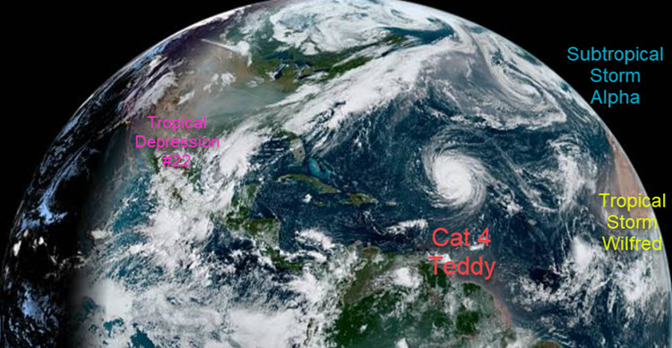
Tropical Storm Wilfred and Subtropical Storm Alpha formed in the far eastern Atlantic on Friday, while TD22 is becoming better organized in the Gulf of Mexico. Meanwhile, Category-4 Teddy will make a close approach to Bermuda as a major hurricane on Sunday. Source: NASA/NOAA.
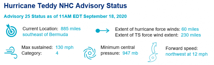
- Bermuda on Watch: While possible Teddy could reach category-5 status in the next 24 hours, the NHC forecast calls for Teddy to track just to the east of Bermuda on Sunday evening. Hurricane watches are likely to be issued Friday evening for the island.
- Rare multiple hurricane season for Bermuda: The last season to have two hurricanes directly impact Bermuda was 2014 when Gonzalo and Fay caused direct impacts to Bermuda. Over the last ten years, Gonzalo and Fay have been joined with Nicole (2016) and Paulette (2020) as direct impacts to the country.
- Teddy heads to Canada: Thereafter, Teddy will begin to weaken and accelerate to the north and eventually north-northwest. There is increasingly likelihood that Nova Scotia and Atlantic Canada will see a direct landfall from Teddy on Tuesday of next week, most likely as a category 1 hurricane.
- Rare Nova Scotia Landfall heading North: In Nova Scotia history, the last hurricane to make a due north landfall on the province was Category-2 Hurricane Juan in 2003.
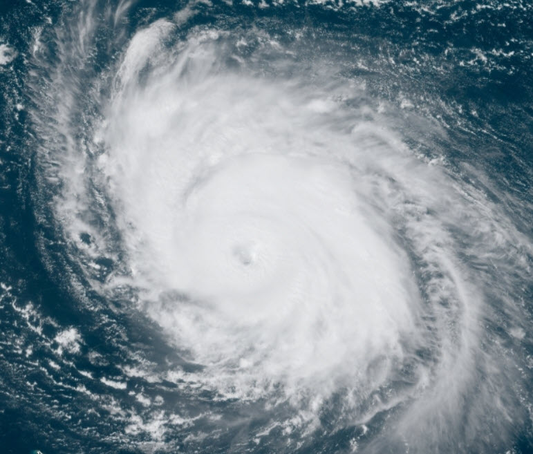
Category-4 Teddy will make a close approach and potentially directly impact Bermuda on Sunday. Source: NOAA/NASA.
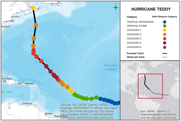
Hurricane Teddy Track and Forecast. Source: NOAA/NHC.
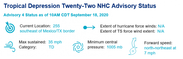
- Status: TD22 is currently stirring in the Gulf of Mexico, moving at a slow pace generally northward. TD22 is rather disorganized heading into the weekend, but looks to be improving in structure as the day goes on. Hurricane Hunters scheduled to investigate the storm’s structure earlier this morning were forced to turn around following a lightning strike disabling the aircraft’s radar system, so any significant updates on the disturbance are likely to be delayed until later today.
- Forecast Challenge: TD22 presents a mixed bag of forecast confidence, providing forecasters a significant challenge. TD22 is currently in an environment conducive for strengthening, and as the storm becomes more organized, modest intensification is expected through the weekend with the potential to reach hurricane status. Weather forecast models are firmly in agreement that the storm will gradually lose forward speed and begin slowly drifting west over the weekend as a ridge builds over the southeast U.S., but this slow drift has resulted in significant uncertainty in terms of the storm’s track, timing and impacts.
- Impacts: While it is too soon to determine direct impacts from this storm, wind, surge, and rainfall impacts are becoming increasingly possible across the western Gulf of Mexico from northern Mexico through coastal Texas and Louisiana. Significant stalling of the storm could lead to extreme rainfall and significant flooding potential.
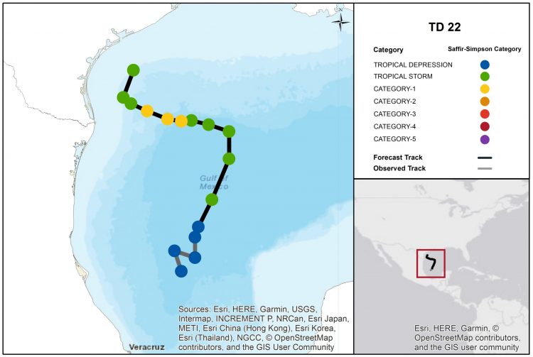
TD22 Track and Forecast. Source: NOAA/NHC.
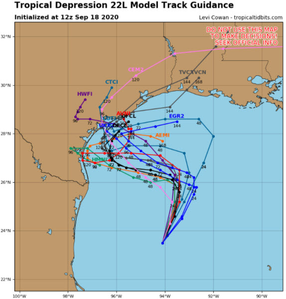
Model track guidance of TD22, highlighting the significant amount of uncertainty. Source: Tropical Tidbits.
2020 Atlantic Hurricane Season Continues to be Record-breaking
Tropical Storm Wilfred’s formation earlier today shattered the existing record for the earliest twenty-first storm on record (October 5, 2005 ) and officially closes out the list of 2020 Atlantic hurricane season names. The formation of Subtropical Storm Alpha is only the second time in history (2005) the Greek Alphabet has been invoked due to extreme seasonal frequency, and formed a full month before Wilma in 2005 as the 22nd named storm. Alpha will be short lived, expected to make landfall in Portugal early Saturday with maximum sustained winds of 50 mph. Based on historical NOAA data, Alpha joins only Vince (2005) and Leslie (2018) to directly make landfall on the Iberian Peninsula in recorded history.
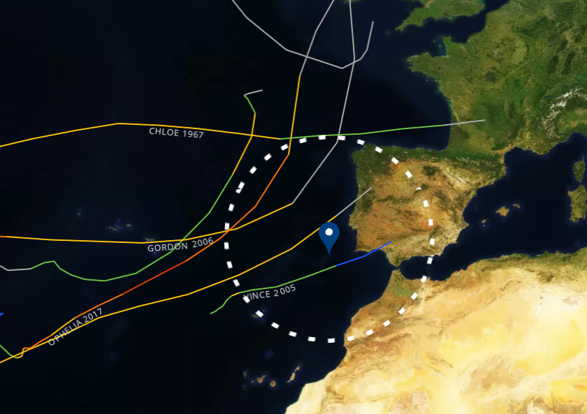
Named storms with the closest approach in known history to Portugal. Source: NOAA/NHC.
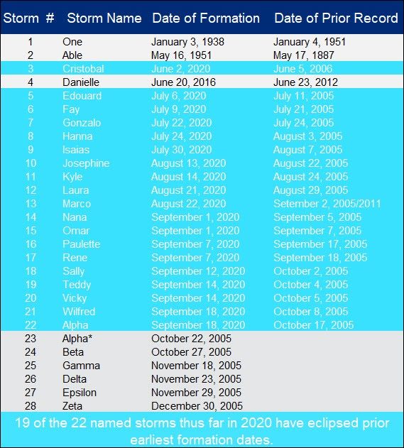
*If TD22 is named Beta, it will break the record for the twenty-third earliest named storm. Compilation of all earliest number storms in the Atlantic season, highlighting the record pace of 2020. Source: NHC/Guy Carpenter.
Updates and Useful Links
Email alerts for Weather Sentinel and CAT-i reports are available on a subscription basis at the GC Preference Center here.
Daily, global tropical cyclone alerts are also available on a subscription basis here.
U.S. National Hurricane Center
Portuguese Institute for Sea and Atmosphere
Bermuda Weather Service Environment Canada
Official statements from the NHC and U.S. National Weather Service, and those of emergency management agencies supersede this update, and should be closely monitored concerning matters of personal safety.