
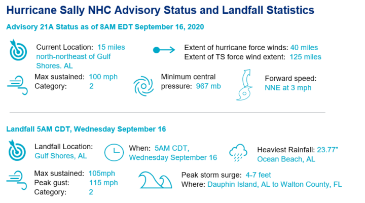
Hurricane Sally made landfall at 4:45 am local time near Gulf Shores, Alabama as a Category-2 Hurricane. Sally is the fourth hurricane to make landfall in the continental U.S. this year and is the first hurricane to make landfall in Alabama since Hurricane Ivan in 2004. Sally is forecast to move inland slowly today while weakening, before regaining forward speed along a northeasterly track later tonight. Widespread wind impacts are expected as hurricane conditions will persist from the Mississippi coast to the western Florida Panhandle. Significant flooding is occurring along the coast and inland from Tallahassee, Florida to Mobile, Alabama and conditions are expected to worsen through today.
- Historic season continues: Sally’s landfall marks the 8th named storm to make landfall this year along the continental U.S. coast, the most since 1916. Additionally, Sally is the 6th Atlantic Hurricane to make landfall this year, joining Hanna, Isaias, Laura, Nana, and Paulette as hurricanes that have all strengthened by at least 15 mph in the 24 hours prior to landfall.
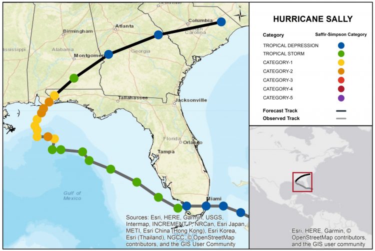
- Eastward shift: Sally’s decrease in forward motion yesterday and overnight led to a near stalling of the storm in the Gulf, ultimately resulting in a landfall to the east of yesterday’s forecast. This eastward shift put Pensacola, Florida, in some of the strongest portions of the storm.
- Significant impacts: Hurricane conditions are ongoing in southeastern Alabama and the western Florida Panhandle. Sustained winds of 100 mph were observed at the mouth of Mobile Bay during landfall. Catastrophic flooding due to 20 inches plus of rain combined with a 4-6 foot storm surge is likely along the Florida Panhandle.
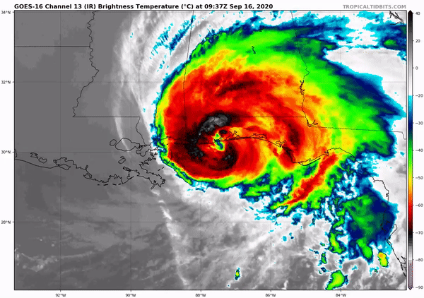
Satellite (infrared) image of Hurricane Sally at landfall in Gulf Shores, Alabama around 5 am local time. Source: TropicalTidbits.
Impacts Discussion
- Wind damage: Hurricane conditions are ongoing in coastal areas of Alabama and the western Panhandle of Florida and are spreading inland. Doppler weather radar estimates sustained winds of 100 mph with higher gusts. Winds of this strength are capable of producing downed trees and powerlines in addition to variable property damage. Widespread power outages can be expected in addition to the potential for tornado activity through tonight in southern Alabama, the western Florida Panhandle, and southwestern Georgia.
- Heavy rainfall/inland flooding: 8 to 12 inches of additional rainfall are forecast through this afternoon as Sally moves inland through Alabama, with localized higher amounts possible. Storm totals of 10 to 20 inches of rainfall across a widespread area are projected with isolated amounts up to 35 inches possible. Excessive rainfall could exacerbate uprooting of trees and will lead to widespread flooding, in the form of flash flooding and urban flooding as well as minor to moderate river flooding in affected areas.
- Storm Surge: NHC peak surge forecasts place the maximum storm surge elevations from Hurricane Sally to be between 4 to 7 feet from the Alabama-Florida state border to the Okaloosa-Walton counties boundary in Florida, including Pensacola Bay. Just past 7 AM CDT the NOAA water level station at Pensacola, Florida was reporting a water level of 6.7 feet above NAVD88 datum which is the highest water level at the station since Hurricane Katrina (2005). Elevated coastal water levels driven by storm surge will compound the effects of inland flooding by impeding the draining of inland precipitation via coastally connected outlets.
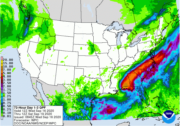
Sally 3 day rainfall forecast trhough 7 AM CDT September 19. Source: NOAA/NHC.
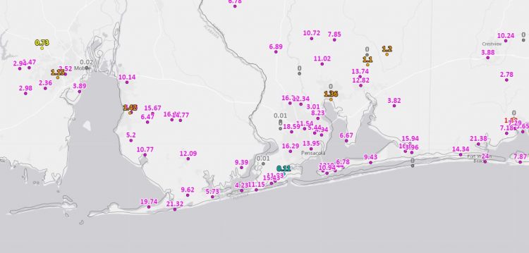
Observed accumulated rainfall totals for Sally, indicating 19-21 inches of rainfall near the mouth of Mobile Bay. Source: NOAA/EDD.
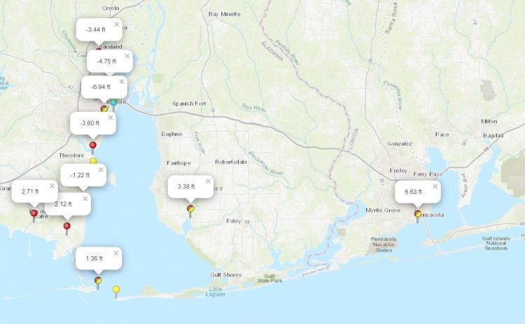
NOAA Coastal Tidal Gauges, 8 am CDT, showing an evacuation of 7 feet of water from Mobile Bay, and water levels nearly 7 feet above mean tide in Pensacola. Source: NOAA/NHC.
Atlantic Basin
The active hurricane season of 2020 continues, as four named storms and a handful of other disturbances move about the Atlantic. Notably, Teddy recently strengthened into a hurricane and is forecast to reach major hurricane status later this week. Aside from Sally’s immediate impacts, no threats to land are apparent within the next five days. The activity in the Atlantic Basin will continue to be monitored.
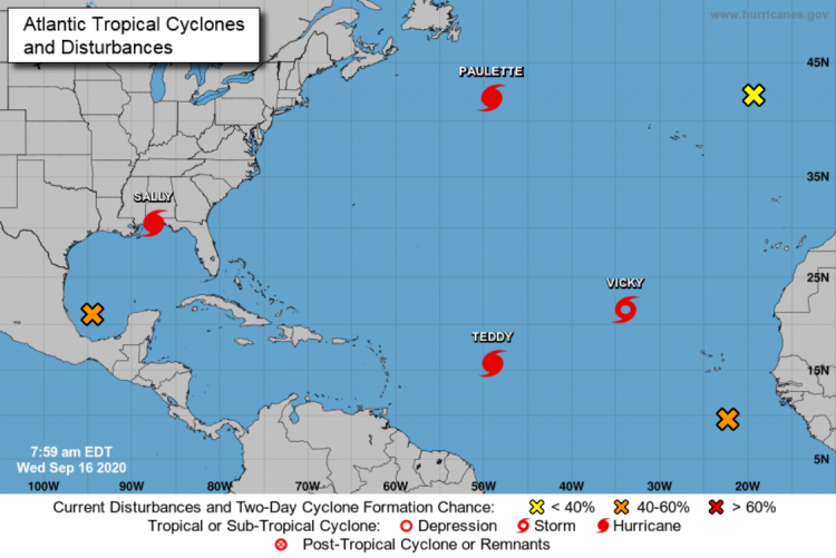
Active named storms in the Atlantic basin in addition to disturbances with formation potential in the next five days. Source: NOAA/NHC.
Updates and Useful Links
Email alerts for Weather Sentinel and CAT-i reports are available on a subscription basis at the GC Preference Center here.
Daily, global tropical cyclone alerts are also available on a subscription basis here.
U.S. National Hurricane Center
Official statements from the NHC and U.S. National Weather Service, and those of emergency management agencies supersede this update, and should be closely monitored concerning matters of personal safety.