

The strongest Santa Ana Wind event thus far of 2020 is forecast for Monday and Tuesday in southern California with wind gusts forecasted to reach 70 miles per hours in terrain-favored areas of the coastal mountains. Low relative humidities and a developing drought makes conditions favorable for quick spread of fires following ignition and extreme fire behavior making suppression efforts challenging. To the east in Colorado, two fires, the Cameron Peak Fire and the East Troublesome have burned more than a combined 400,000 acres and have forced numerous evacuations.
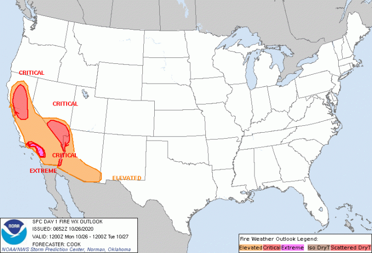
Day One Fire Weather Outlook Source: Storm Prediction Center
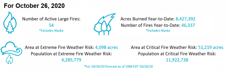
California Extremely Critical Wildfire Weather
Extremely critical fire weather is predicted for portions of California, including the L.A. County communities of Riverside and San Bernardino, in response to the strongest offshore wind event of the season so far. Wind gusts of 60-70 mph have been observed as of Monday morning. The meteorological set-up is quite classic; the pressure gradient between the Great Basin and coastal California is very strong, driving winds down the slopes of the Sierra Nevada Mountains and the coastal ranges of California. Not only are these winds gusting to high speeds, but as air flows downwards, it warms and dries. This virtually moisture free air mass has the potential to very quickly dry out any remaining moisture in the vegetation. Windy conditions are expected to persist through Tuesday, and gradually weaken into Wednesday.
The same offshore wind phenomena that is occurring in Southern California is also occurring in the Bay Area and foothill communities of the Sierra Nevada in Northern California, which are at a critical fire weather risk. These areas have already been very hard hit during the 2020 wildfire season after the passage of a lightning system in August caused several large and damaging wildfires. Fire crews were able to utilize an extended period of advantageous conditions to bring many of the large fires under full or near-full containment. This includes the August Complex Fire in northern California which is now 93 percent contained and is the largest fire in California history at 1,032,548 acres. For context, the state of Rhode Island is approximately 989,000 acres. Remarkably, despite the August Complex's massive size CalFire reports that as of October 22 only 54 structures have been destroyed and 6 structures damaged by the fire. In fact, the acreage burned in the 5 largest fires of the 2020 California wildfire season is greater than the acreage burned in the 5 largest wildfires of all other seasons combined.
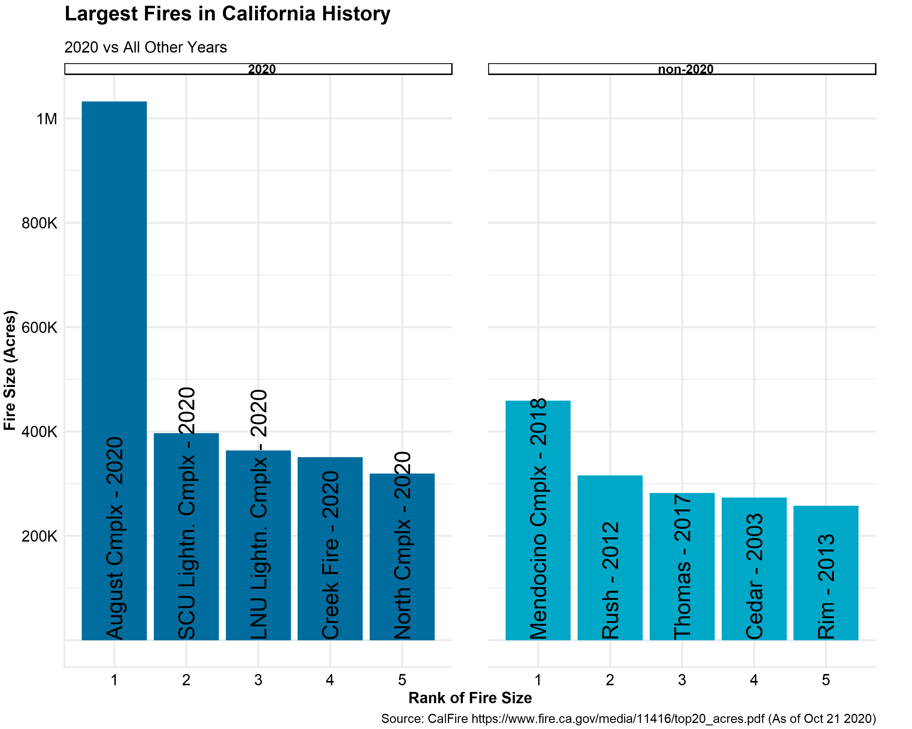
Rank of fire size for 2020 California wildfire season (left) and non-2020 wildfire season (right). Source: Guy Carpenter and CalFire
Historic Colorado Wildfire Season 2020
The 2020 wildfire season in Colorado has been historic, and is most specifically characterized by the size and seasonality of several large wildfires. The two largest wildfires in state history, the Cameron Peak Fire and the East Troublesome Fire, are continuing to smolder under the snow only 10 miles apart near Rocky Mountain National Park in late October. In fact, the acreage burned in the 2020 wildfire season alone, with the fires mentioned above and the large Grizzly Creek and Pine Gulch fires of the western slope, amount to more acreage burned than any other 5 year span combined since 2000. The 3 largest wildfires in state history all have occurred in 2020. The fires have forced thousands of evacuations and hundreds of structures have been lost, although the exact count is still being tallied.
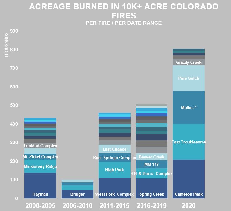
Colorado 10,000 acre plus fires since 2000. Compiled by 5 year increments, with 2020 stand alone. Source: Guy Carpenter and Rocky Mountain Area Coordination Center stats
An important driver of this late and damaging Colorado wildfire season are the drought conditions the entire state has been under, including a late start to the typical fall moisture that occurs in the mountains. It has been unseasonably warm and dry, allowing these large fires to burn through areas that are dominated by pine beetle killed stands of lodgepole and ponderosa that are ready fuels for fire. Both the East Troublesome and Cameron Peak Fires exhibited single day runs of over 15 miles, driven by strong downslope wind events.
A significant snowfall event occurred across much of the state of Colorado on Sunday, halting the progression of wildfire; over 15 inches fell on active portions of the Cameron Peak and East Troublesome Fires. It remains to be seen whether this is an event ending snowfall. The fire can smolder under the snow and easily re-ignite should dry or windy conditions re-establish in areas where the fire has not been completely extinguished.
Wildfire Outlook into November
As is typical for the late summer into early autumn period in California precipitation is minimal however, much of California has seen less than 5 percent of the already low expected precipitation over the past sixty days. In fact, many parts of California has seen zero precipitation over this period which in conjunction with above average temperatures over the same period has created exceedingly dry fuels increasing the likelihood of ignitions and subsequent rapid spread of wildfires. This lack of precipitation has manifested itself as extreme drought conditions in northern California where 10-hour fuel moistures (representative of fuels with a diameter of less than 1 inch) are below 5 percent. Recent elevated humidities in southern California have elevated fuel moistures despite the lack of precipitation and the region remains drought-free according to the United States Department of Agriculture Drought Monitor. However, the National Weather Service Climate Prediction Center (CPC) indicates the likely development of drought in the southern California region over the coming months.
These conditions in conjunction with the onset of seasonal offshore winds represents a period of elevated wildfire risk. 1,000-hour fuel moisture (representative of fuels with a diameter of 3 to 8 inches) remains low across much of the western US with the exception of parts of the Pacific Northwest where both fine (10-hour) and coarse (1,000 hour) fuels moistures are elevated due to recent precipitation. In fact, the CPC indicates drought improvement and or drought removal for nearly the entirety of Oregon and Washington and parts of Montana and Idaho over the coming months. Unfortunately, much of the rest of the western US that is currently suffering from ongoing drought conditions is expected to continue to experience persistent drought conditions with additional areas expected to develop drought. Fortunately conditions conducive to wildfire will diminish as temperatures drop.
- Above normal significant wildfire potential is expected across coastal California, the Sierra Nevada Mountains, and parts of inland northern California through the end of October with potential returning to normal in November for all areas in the U.S. with the exception of coastal southern California and parts of northern California.
- Climatological outlooks indicate above normal temperatures and below normal precipitation for southern California which along with forecast above normal offshore wind events will maintain above normal significant wildfire potential until January 2021 when precipitation levels are expected to be enough to lower significant wildfire potential to normal conditions.
- After several months of elevated significant wildfire potential the Four Corners and Great Basin regions will return to normal significant wildfire potential by November.
- Above normal fire potential is expected for parts of eastern Texas and Oklahoma in January due to forecast elevated temperatures and below normal precipitation.
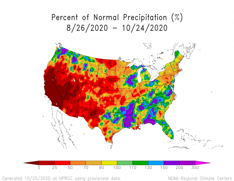
Observed 60 day precipitation percentage of normal Source: High Plains Regional Climate Center
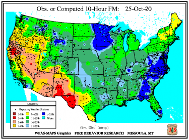
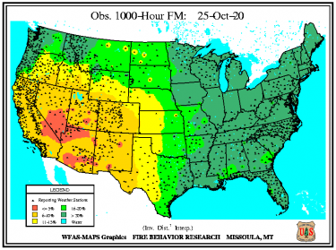
Observed 10-hour (left) and 1000-hour (right) fuel moisture percentage of normal. Source: Wildland Fire Assessment System
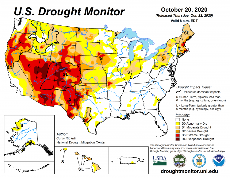
U.S. Drought Monitor. Source: United States Drought Monitor
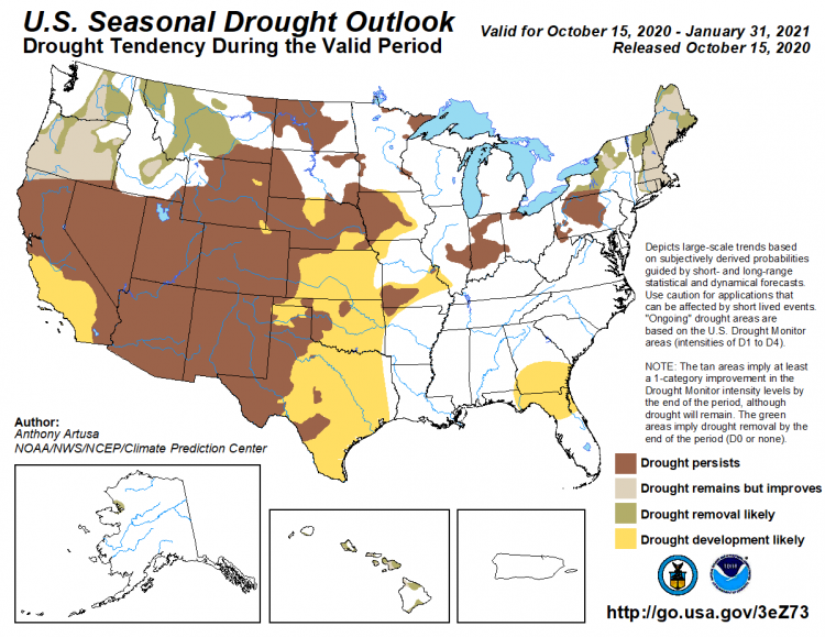
U.S. Seasonal Drought Outlook. Source: National Weather Service Climate Prediction Center
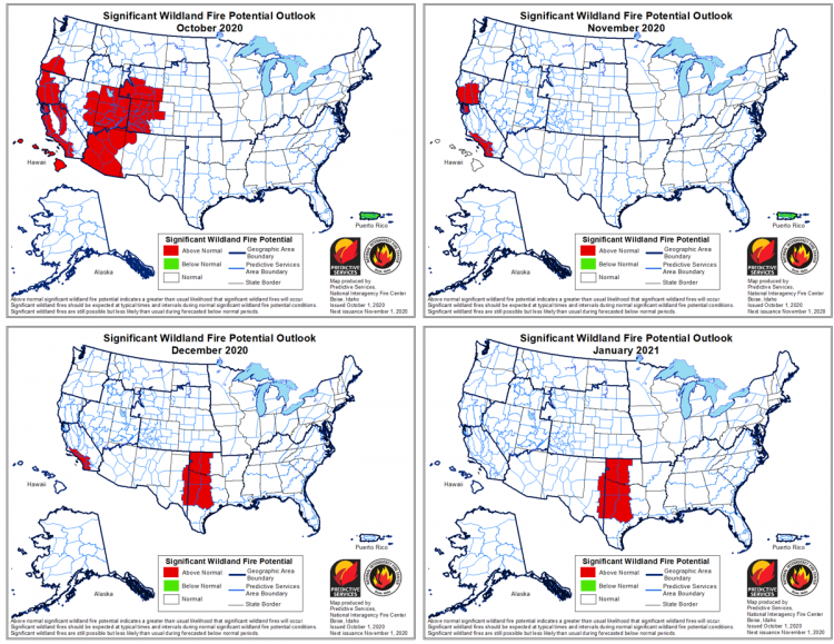
Significant Wildfire Outlook October 2020 - January 2021. Source: National Interagency Fire Center
In addition to this update please be sure to read the recent publication on GC Capital Ideas discussing the drivers of wildfire risk and the suite of tools Guy Carpenter offers to quantify wildfire risk:
Wildfire: Understanding and Modeling the Risk
Updates and Useful Links
GC Meteorologists and Wildfire Experts will continue to monitor the developing wildfire situation and post updates as necessary.
Email alerts for Weather Sentinel and CAT-i reports are available on a subscription basis at the GC Preference Center here.
California Department of Forestry and Fire Protection (CalFire)
National Wildfire Coordinating Group - Incident Information System
Official statements from emergency management agencies supersede this update, and should be closely monitored concerning matters of personal safety