
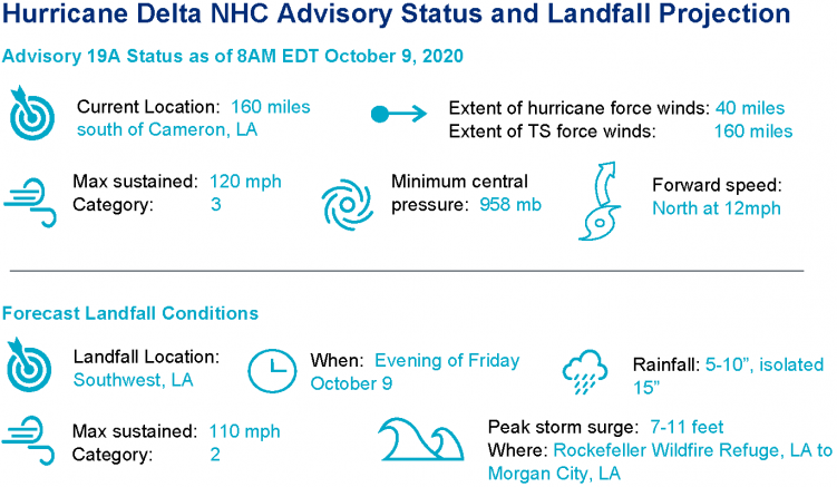
Hurricane Delta is on final approach to the southwest Louisiana Coast as a category-3 hurricane. The outer bands of the storm have already moved ashore and conditions will deteriorate through the day. The National Hurricane Center forecast is for landfall later this evening as a probable category-2. Delta will then weaken as it moves inland toward the Tennessee Valley. Seawater inundation due to storm surge, inland flooding due to heavy rainfall and destructive winds are probable along with a tornado threat. Impacts will be amplified for those areas previously affected by Hurricane Laura.
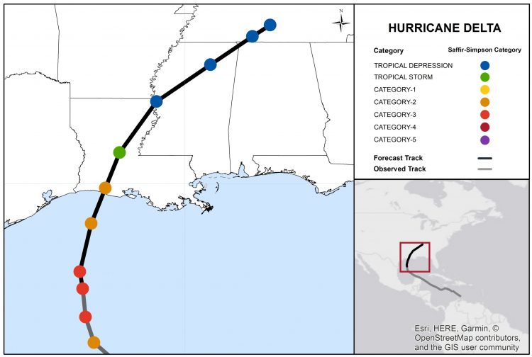
Hurricane Delta Track and Intensity Forecast. Source: NOAA/NHC.
- Track Forecast: The forecast reasoning for Hurricane Delta is unchanged since the last discussion. The hurricane has started a turn toward the north and should take more of a north-northeasterly course over the coming hours. The turn is the result of interaction with a disturbance over the mainland, as well as the western edge of a subtropical ridge. Landfall is expected later this evening over the southwest Louisiana Coast, where conditions are already deteriorating. The storm should then weaken and hook towards the Tennessee Valley over the weekend.
- Intensity Forecast: Delta retains status as a category-3 hurricane as it makes final approach to the northern Gulf Coast. The hurricane is moving into an environment with reduced ocean heat content and increasing wind shear, which should gradually reduce the strength of the storm. Accounting for these factors, the NHC best forecast is for some weakening, to maximum sustained winds of 110 mph prior to landfall later this evening.
Expected Impacts
- Wind: Significant wind impacts to property and infrastructure are probable near and to the right of the core of the storm. Effects will be amplified for those areas still recovering from Laura, particularly with the threat of airborne debris from prior damage. Downed trees and powerlines with variable property damage will affect broader areas well away from the center of circulation. Some damage from tornado activity is also possible.
- Rainfall and flooding: 5 to 10 inches of rainfall are expected, with isolated amounts of 15 inches in southwest and south central portions of Louisiana. Significant flash, urban, and isolated riverine flooding is possible as a result. Delta will also bring significant rainfall amounts to parts of the lower Mississippi Valley, Tennessee Valley, and Ohio Valley as it moves northeast over the weekend.
- Storm Surge: The large size of the storm together with duration of winds will produce a storm surge of up to 11 feet in some areas. This will render property damage to immediate coastal areas and adjacent waterways due to seawater inundation, water velocity damage and waterborne debris, with wave bettering impacts possible for immediate coastal areas previously affected by Hurricane Laura. Elevated water levels will also impede drainage from stormwater management systems, to amplify the threat from freshwater flooding.
- Watches and warnings are active for areas under threat. Specifics can be found at www.weather.gov.
Historical Context
Hurricane Delta will be the:
- 10th named storm to make landfall on the Continental US this year, surpassing the prior record of nine named storms set in 1916.
- 4th named storm landfall in Louisiana this year, tying the 2002 season for the record.
- One of only six major hurricanes in the Gulf of Mexico during the month of October since the satellite era, most recently including Michael (2018) and Wilma (2005).
- 5th hurricane to make landfall on the Continental US this year; the first time since 2005.
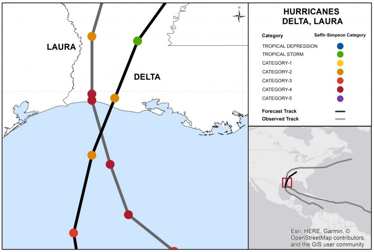
Track and Position Reports for Hurricanes Laura and Delta. Source: NOAA/NHC.
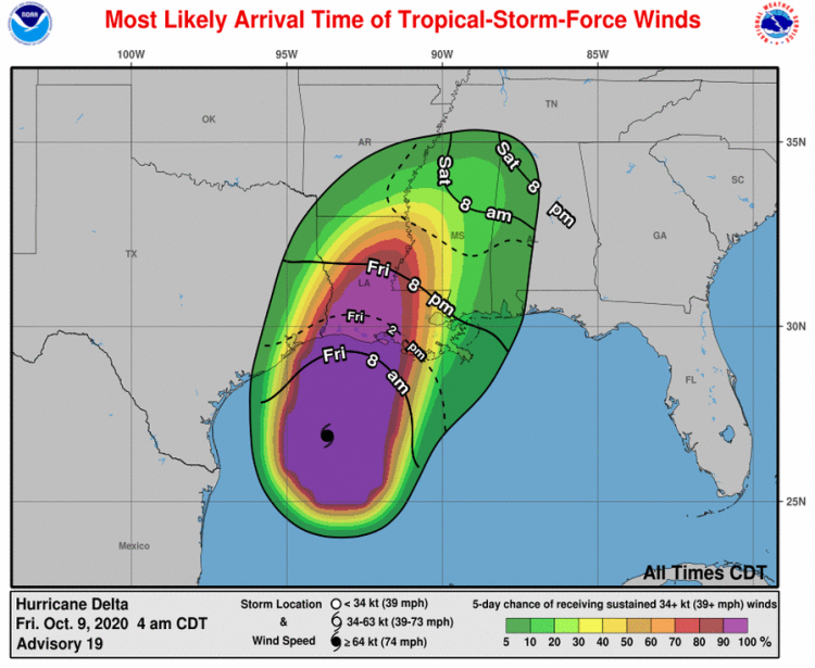
Probability of Tropical-Storm-Force Winds and Most Likely Arrival Time. Source: NOAA/NHC.
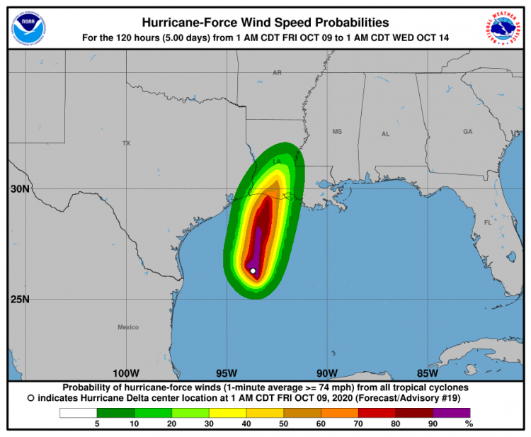
Probability of Hurricane-Force Winds. Source: NOAA/NHC.
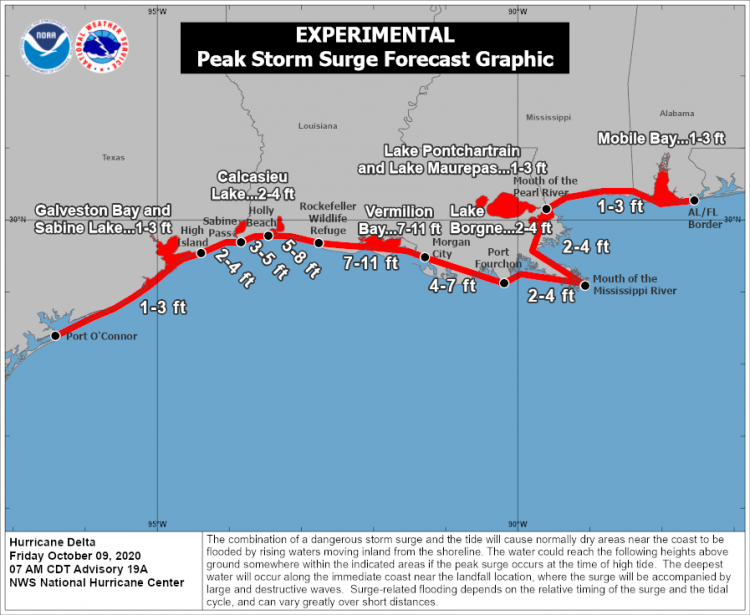
Experimental Peak Storm Surge Forecast. Source: NOAA/NHC.
72-Hour Rainfall Forecast Ending 8AM EDT Monday, October 12. Source: NOAA/WPC.
Updates and Useful Links