
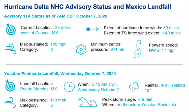
Hurricane Delta rapidly intensified to a category-4 hurricane during the day on Tuesday, attaining wind speeds of 145 mph on a path toward the Yucatan Peninsula. A strong than expected shear environment caused Delta to weaken prior to landfall as a category-2 hurricane in Puerto Morelos, Mexico at 5:45 am CDT Wednesday, bringing destructive wind, rain and storm surge to a highly populated stretch of coastline. Delta is now the strongest Greek alphabet named storm in history, and is the second strongest storm in the Atlantic Basin this year, behind only Hurricane Laura. Furthermore, the strengthening of Delta from a tropical storm to a category-4 hurricane in less than 24 hours is the most rapid intensification witnessed in the Atlantic Basin since Hurricane Wilma in 2005. Hurricane Delta is expected to emerge into the Gulf of Mexico, re-intensify, and begin a path toward the U.S. Gulf Coast later today.
- Rapid Intensification of Hurricane Delta: The official definition of rapid intensification of a hurricane is 35 mph in 24 hours. Delta increased in strength 80 mph, more than doubling from a 60 mph storm at 2 pm EDT Monday to 140 mph at 2 pm EDT Tuesday. This statistic places Delta as the most rapidly intensifying hurricane in the Atlantic Basin since Hurricane Wilma in 2005.
- Impact of Delta on Quintana Roo, Mexico: As Delta made landfall in Puerto Morelos, Mexico this morning, sustained winds of 110 mph were observed. Significant storm surge of up to 9 feet accompanied by destructive wave action is forecast from Cabo Catoche to Progresso. The unexpected weakening of Delta just prior to landfall likely reduced some of the more extreme impacts, however significant structural damage is expected, especially in coastal areas. An evacuation of over 32,000 tourists has been necessary. Delta is the first hurricane to make landfall in the state of Quintana Roo since Ernesto in 2012.
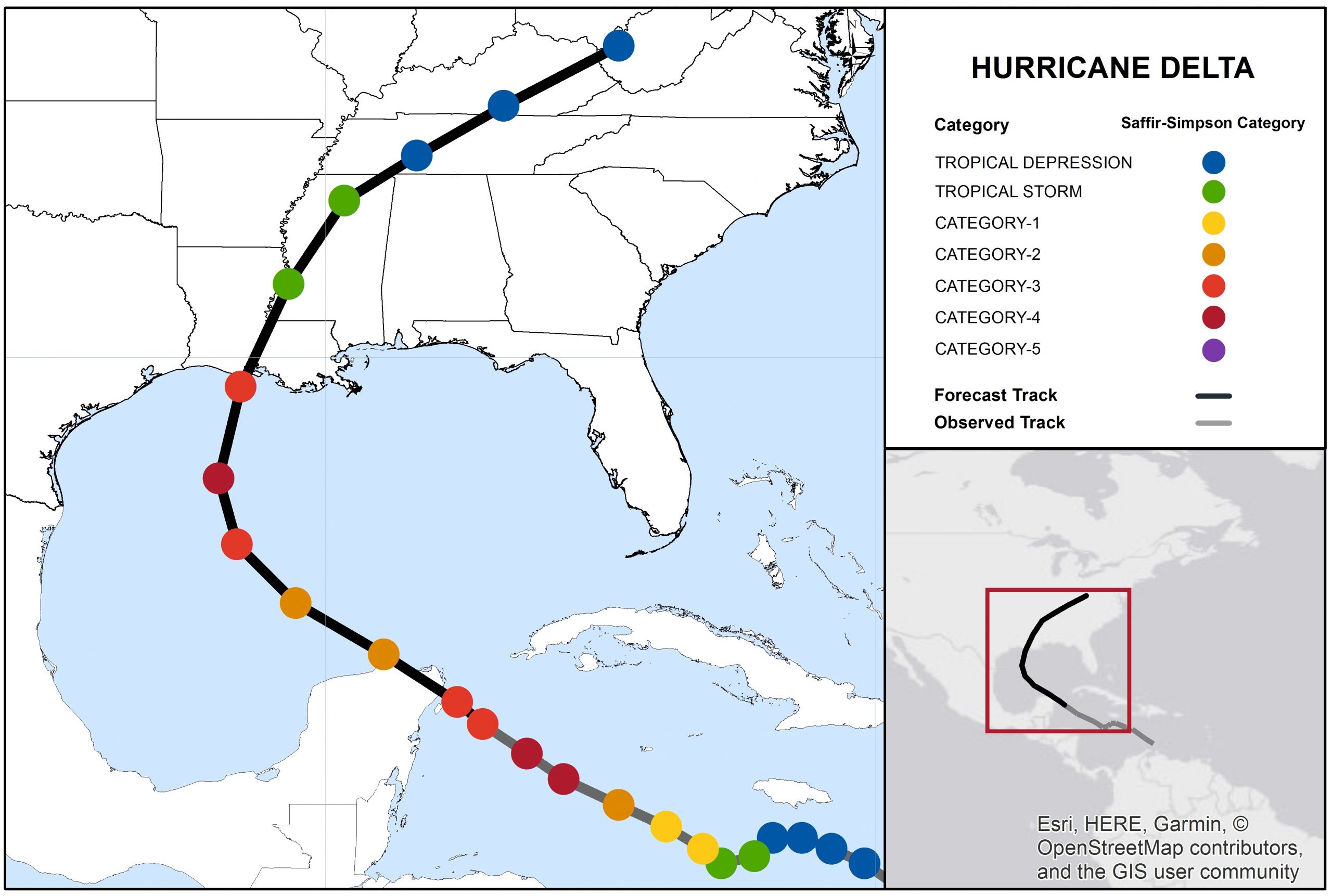
- Forecast Track and Intensity: Model intensity guidance and the NHC forecast Delta to re-intensify to category-4 strength within the next 36-48 hours over the very warm waters of the southern Gulf of Mexico. However, prior to landfall, the storm should track through cooler waters adjacent to the coast and a higher shear environment, which will likely weaken the system. Model track guidance is tightly clustered on a landfall along the central U.S. Gulf coast. There remains some uncertainty in the landfall strength, although currently the NHC is forecasting a category-3. It should be noted that Hurricane Delta is expected to grow in size, if not strength, which will bring hazardous conditions to a wide stretch of coastline outside of the immediate landfall location.
- Gulf Coast at Landfall: Expected impacts include considerable damage to property and infrastructure from category-3 winds near the core of the storm, with downed trees and powerlines and resulting power outages over a broader area extending well away from the center of circulation. Flood impacts due to seawater inundation could be severe given the size and strength of the storm. Damage to property and infrastructure from seawater inundation, water velocity and waterborne debris are probable, with wave battering also probable for immediate coastal areas. Inland flooding due to heavy rainfall can also be expected, especially for low-lying or otherwise flood-prone areas.
- Record Breaking Delta: The rapid intensification of Delta is likely to break records in the Atlantic Basin. Additionally, at peak strength, Delta was the second strongest Atlantic Basin storm of 2020, behind only Laura. It is also the strongest Greek Alphabet named storm in history. If Delta makes landfall in the U.S. as a hurricane it will set a new seasonal record of 10 landfalls. If Delta meets the requirements for retirement of the name, it will be retired as “Delta 2020”, and the Greek Alphabet letter of Delta will continue to be used.
Hurricane-Force Wind Speed Probabilities for next 120 hours. Source: NHC.
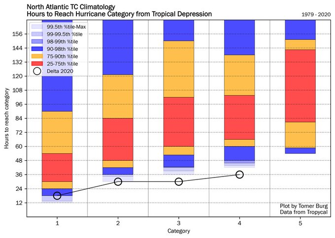
Statistics on Rapid Intensification of Atlantic Basin Hurricanes. Delta's strengthening of 80 mph in 24 hours indicates it may hold a record for intensification from a tropical storm to a category 4 storm. Source: Twitter @burgwx Tomer Burg.
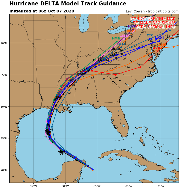
Model track guidance of Delta, highlighting the high degree of agreement. Source: Tropical Tidbits.
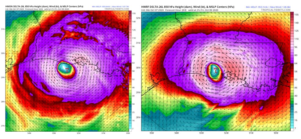
Model Intensity Forecast and landfall for the HMON model (left) and the HWRF model (right), showing large major hurricane landfalls. Source: Tropical Tidbits.
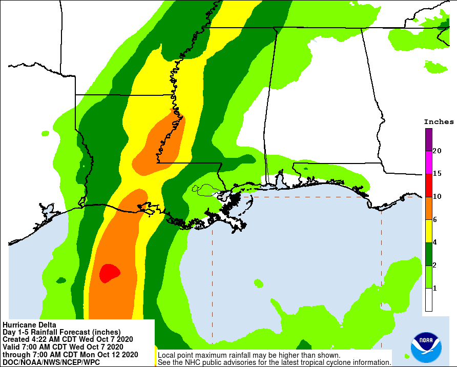
5-Day precipitation forecast through 8 AM EDT October 12. Source: NOAA/NHC.
Updates and Useful Links
Email alerts for Weather Sentinel and CAT-i reports are available on a subscription basis at the GC Preference Center here.
Daily, global tropical cyclone alerts are also available on a subscription basis here.
U.S. National Hurricane Center
Official statements from the NHC and U.S. National Weather Service, and those of emergency management agencies supersede this update, and should be closely monitored concerning matters of personal safety.