

Super Typhoon Goni made landfall on Bato (Catanduanes province, Philippines) around 4:50 AM local time on Sunday, November 1 as a Category 5-equivalent super typhoon. 1-Minute sustained winds prior to landfall were around 315 km/hr (195 mph). The storm made three additional landfalls while tracking north-west and passed south of the National Capital Region. Severe wind damage has been reported to property and infrastructure in various provinces, especially Catanduanes and Albay.
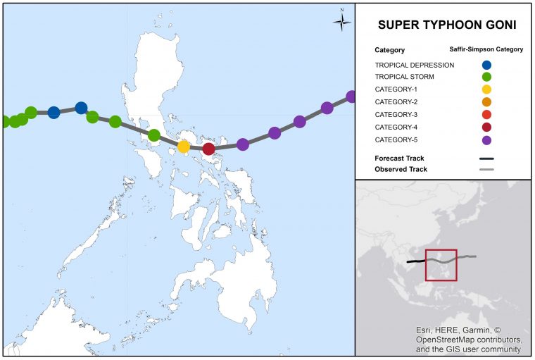
Super Typhoon Goni Track and Position Reports. Source: Joint Typhoon Warning Center.
The Super-Typhoon Goni (Rolly) bulletin comprises the following sections:
- Regional Impacts
- Notable Impacts by Sector
- Physical Discussion
Regional Impacts
Typhoon Goni primarily affected the Bicol region. According to officials, at least 20 people died and over 389,000 were evacuated. The event caused extensive damage to property, roads, bridges, power lines, and communication networks in the provinces of Catanduanes and Albay. Damage was also reported in Camarines Sur, Quezon, Batangas, and Sorsogon. According to authorities over 100 cities and towns experienced power and telecommunication failures, while others were affected by disruption in water supply.
The National Capital Region appears to have been spared the most severe impacts. A full assessment of damage will take several more days, as communication with affected communities is progressively restored. Catanduanes Province According to government officials, over 10,000 houses were destroyed or damaged and at least six people died in the island province of Catanduanes, where the storm made first landfall with 1-minute sustained winds of around 315 km/h (195 mph), and central pressure of 887 hPa (mb).
According to the International Federation of Red Cross and Red Crescent Societies (IFRC), the typhoon destroyed between 80 to 90 percent of the buildings in the city of Virac, home to over 70,000 people and among the first areas to be affected by the typhoon. Several bridges in the province collapsed, and roads were made impassable due to debris, flooding, and landslides. At least eleven towns were reported to be inaccessible. The strong winds caused power outages and downed communication lines causing vast areas of the province to be unreachable without satellite phones. Albay Province According to initial media reports, at least ten people died in the Albay province. Strong winds caused widespread damage to property and power lines. Storm surge caused seawater inundation of coastal towns, and extreme rainfall caused rivers to overtop their banks causing widespread flooding.
Heavy rainfall also caused lahar flows affecting the towns of Guinobatan and Camalig, where over 300 houses were buried under a mix of mud, volcanic rocks and other pyroclastic material from the nearby Mayon Volcano. In the meantime the event cut off power supply and communications services. Roads and railways were affected by mudslides and landslides, and a train was partially submerged. A bridge collapsed, and a dike break triggered flooding in the city of Camalig. The strong winds tore off roofs of numerous buildings, including two evacuation centers. Damage was also reported by media to the local airports of Naga and Legazpi, as well as to the Ateneo de Naga University. Other Provinces Widespread flooding was reported by media in Batangas City (Batangas province), where hundreds of people had to be rescued from their homes.
According to local authorities, the typhoon brought impacts and disruption to the towns of Donsol, Pilar, and Castilla in Sorsogon province. Two villages in the coastal city of Calamba (Laguna province) were inundated. In Quezon province, areas of the municipalities of Lopez and San Francisco were flooded, with loss of power supply in ten towns.
Notable Impacts by Sector

Supply Chain & Transportation Air and railway traffic were disrupted in multiple provinces. Flights and trains were also suspended in the capital region, where the Manila International Airport Authority (MIAA) closed the Ninoy Aquino International Airport on November 1. Many domestic and international flights were cancelled.

Agriculture & Livestock Preliminary estimates from Philippines’ Department of Agriculture indicate that winds caused crop damage amounting to more than 2 billion pesos (USD 41.3 million). According to authorities, preparation measures enabled the protection of about 600,000 acres of rice fields.
Physical Discussion
- The system was initially identified on October 27 by the Japan Meteorological Agency (JMA), that began to monitor a tropical disturbance west of the Mariana Islands. The Philippine Atmospheric, Geophysical, and Astronomical Services Administration (PAGASA) and the United States’ Joint Typhoon Warning Center (JTWC) started to issue advisories soon after.
- By October 28 the system had already turned into a tropical depression while tracking westward. Soon after it reached tropical storm status and was assigned the name “Goni” by the JMA. On October 29 the system underwent a period of rapid intensification while moving towards the Philippines and was upgraded to a typhoon. As it entered the Philippine Area of Responsibility, PAGASA named it “Rolly”.
- In the hours that followed, the system gained further strength and on October 30 around 2 PM (Philippines time) it had strengthened into a category-5 equivalent super typhoon, the first of the season for the Northwest Pacific Basin.
- Goni made its first landfall in Bato (Catanduanes province) on November 1 at 4:50 AM, local time. Other landfalls followed on the same day on Tiwi (Albay province) at 7:20 AM, San Narciso (Quezon province) at around 12:00 PM, and on Lobo (Batangas province) at 5:30 PM.
- During its first landfall, the system had 1-minute sustained winds of around 315 km/hr (195 mph), a category-5 equivalent on the Saffir-Simpson Scale, with a central pressure of 884 hPa (mb). Due to interaction with landmasses and increased wind shear, Goni rapidly weakened while tracking north-west and passed south of the National Capital Region.
- On November 2 around 5:30 AM the system entered the West Philippine Sea a tropical storm. The storm is expected by the JTWC to weaken back to tropical depression status before making final landfall over Vietnam later in the week.
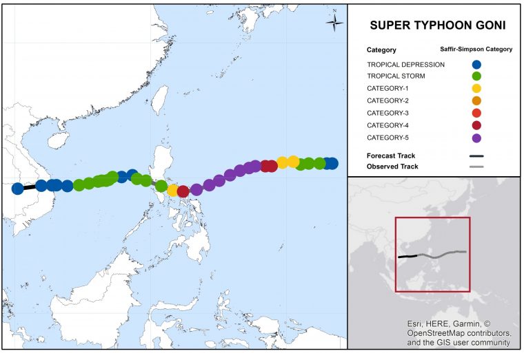
Super Typhoon Goni Track and Position Reports. Initiation to Forecast Landfall over Vietnam. Source: JTWC.[/caption] Sources: Reuters, The Weather Channel, Associated Press, BBC, Aljazeera, The Inquirer, Rappler, CNN, Washington Post, Reliefweb, International Federation of Red Cross and Red Crescent Societies, Philippine Atmospheric, Geophysical and Astronomical Services Administration (PAGASA), NOAA, Japan Meteorological Agency, Joint Typhoon Warning Center.