
High-end category-4 Hurricane Eta will make landfall today on the Nicaragua coastline. The forecast remains unchanged from yesterday as Eta will render catastrophic damage due to winds, storm surge and inland flooding. In modern memory, the most favored analog for ETA is Hurricane Mitch (1998), a category-5 hurricane that resulted in over 10,000 fatalities and USD 5 billion in economic losses (1998 USD) across Honduras, Nicaragua and Central America. While Mitch was stronger than Eta at projected landfall, the majority of fatalities and damages occurred from excessive rainfall and unprecedented flooding as Mitch was a slow moving prolific rainfall producer.
Key Headlines
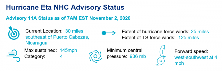
- Peak intensity: Eta intensified to 150 mph maximum sustained winds overnight, tying Hurricane Laura for the strongest Atlantic hurricane of 2020. Thereafter, an eyewall replacement cycle has halted further intensification prior to landfall. While the peak intensity looks to remain at a strong category-4 hurricane, the expansion of the eyewall will result in a larger swath of damaging winds upon landfall.
- Storm surge: Peak storm surge heights of 14-21 feet above normal high tide will cause severe destruction of property and infrastructure in coastal areas of Nicaragua and far eastern Honduras.
- Slow moving prolific rainfall producer: Eta will move very slowly over the next 72 hours westward, bringing rainfall totals of 20-30 inches with isolated heavier totals in mountainous areas of Central America. Life threatening flash flooding, river flooding and landslides in steep terrain are items of concern for safety of population in the path of Eta.
- Longer range uncertainty: The majority of weather models project Eta to emerge back into the western Caribbean by Friday. Thereafter, weak steering currents result in highly uncertain outcomes for Eta with a wide range of outcomes projected by current weather model guidance.
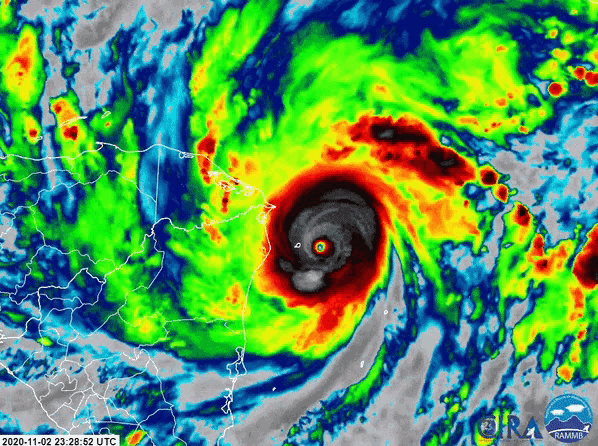
Infrared satellite loop of category-4 Hurricane Eta moving southwest towards a Nicaragua landfall Tuesday afternoon. Source: CIRA/NOAA.
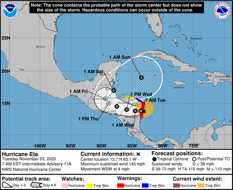
Track and intensity forecast for Hurricane Eta. Source: NHC. Historical Perspective
- Rapid intensification: In a season of above average number of tropical systems undergoing rapid intensification, Eta was the strongest yet of the 2020 season. Eta dropped 54 mb in 24 hours yesterday to 934 mb, the largest drop in pressure recorded in an Atlantic hurricane after October. Eta ranks as one of the top ten most rapidly intensifying hurricanes in known Atlantic records, with a 36 hour increase of 90 knots (105 mph).
- Late season: Only two hurricanes in known Atlantic history have been stronger than Eta after the end of October: the Cuba hurricane of 1932 (175 mph) and Hurricane Lenny in 1995 (155 mph).
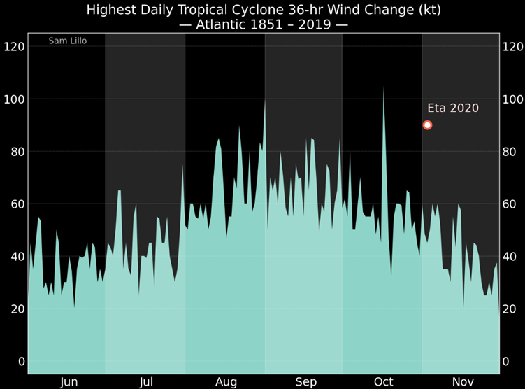
The rapid intensification of Hurricane Eta by 90 knots in 36 hours rivals the most rapidly intensifying hurricanes in Atlantic records, regardless of the time of year. Source: Sam Lillo.
Guy Carpenter meteorologists will continue to track the progress of Eta across Central America and further potential ramifications for the western Atlantic. Statements from official meteorological and emergency management agencies supersede this update, and should be closely followed concerning matters of personal safety.
U.S. National Hurricane Center