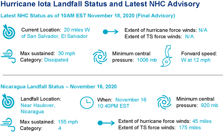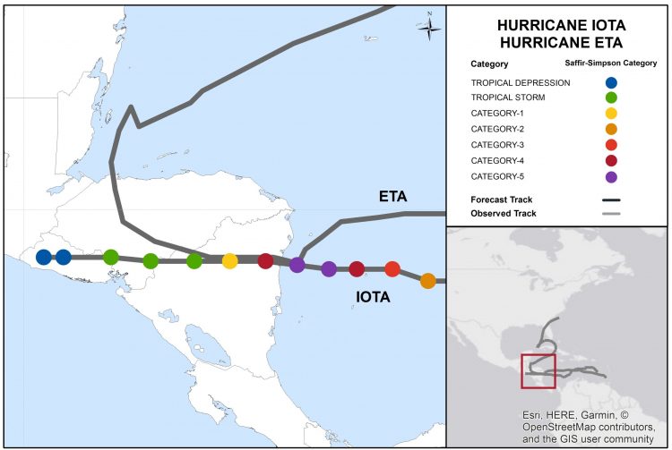
On the evening of November 16th, Hurricane Iota made landfall on the Nicaragua coast as a category-4 hurricane. The center of circulation moved ashore just south of where Hurricane Eta made landfall in recent weeks, with catastrophic effect. Iota has rendered severe to complete damage due to wind along with flooding and mudslides due to heavy rainfall. The impacts affect portions of Central America including Nicaragua, Honduras, Panama and El Salvador.


Hurricane Iota track and intensity with Eta track. Source: NOAA/NHC.
Physical Discussion
Hurricane Iota made landfall near the Town of Haulover, Nicaragua as a very strong category-4 hurricane the evening of November 16th. The center of circulation moved ashore just 15 miles south of where category-4 Hurricane Eta made landfall on November 3rd. In the hours prior to landfall, Iota was a category-5 hurricane with maximum sustained winds of 160 mph, and a central pressure as low as 918 mb according to the National Hurricane Center (NHC). The hurricane was able to reach this peak strength after a period of rapid intensification, running from 90 mph to 160 mph over a 24 hour period. This remarkable gain in strength was enabled in an environment with warm waters, minimal to zero wind shear and very moist air. Hurricane Iota is the thirteenth hurricane of the 2020 North Atlantic Hurricane season, the second-highest number behind the fifteen hurricanes of 2005, over the known historical record.
Post-Landfall
Following landfall, the NHC downgraded Iota to tropical storm status at 1PM EST November 17, as the storm moved westward and approached the Nicaragua-Honduras border. In the meantime, the circulation of Iota caused moisture-laden winds to interact with the topography of Central America, causing great amplification of rainfall amounts for areas previously affected by Eta. The storm was downgraded to tropical depression status at 4AM EST November 18. The feature then dissipated without evidence of a surface circulation, and the final advisory was issued by the NHC at 10AM EST November 18. Forecast rainfall amounts for Iota were on the order of 10-20 inches, with isolated amounts to 30 inches per the NHC. Flood impacts have been especially severe for portions of Nicaragua, Honduras and El Salvador.
Wind Impacts
A wind gust of 113 mph was reported at Puerto Cabezas Airport, about 30 miles north of where the center of circulation moved ashore. According to initial media reports, severe wind impacts occurred in the area where the core moved ashore, with evidence of severe to complete damage to affected properties and infrastructure. Evidence of roof damage is also apparent for regions away from the center of circulation. Damage severity was likely amplified by prior passage of Hurricane Eta. Impacts in Providencia and Santa Catalina were especially severe, with severe to complete damage due to wind.
Flood Impacts
Extensive flooding has been reported for affected areas of Central America, including Nicaragua, Honduras, Panama and El Salvador. Damaging mudslides have also occurred. Impacts to power and drinking water infrastructure have been reported.