
Severe thunderstorms on April 28 produced heavily clustered hail reports in the U.S. Southern Plains. Significant hail of two inches diameter or more was reported, especially in Texas and Oklahoma, with some reports of destructive hail of up to four inches diameter. Impacts are apparent in the areas of San Antonio, Dallas-Fort Worth and Oklahoma City. The activity was initiated in an environment of warm, moist, unstable air with ample wind shear along a frontal boundary slowly crossing the area. These affected areas previously suffered impacts from adverse winter weather conditions during the middle of February.
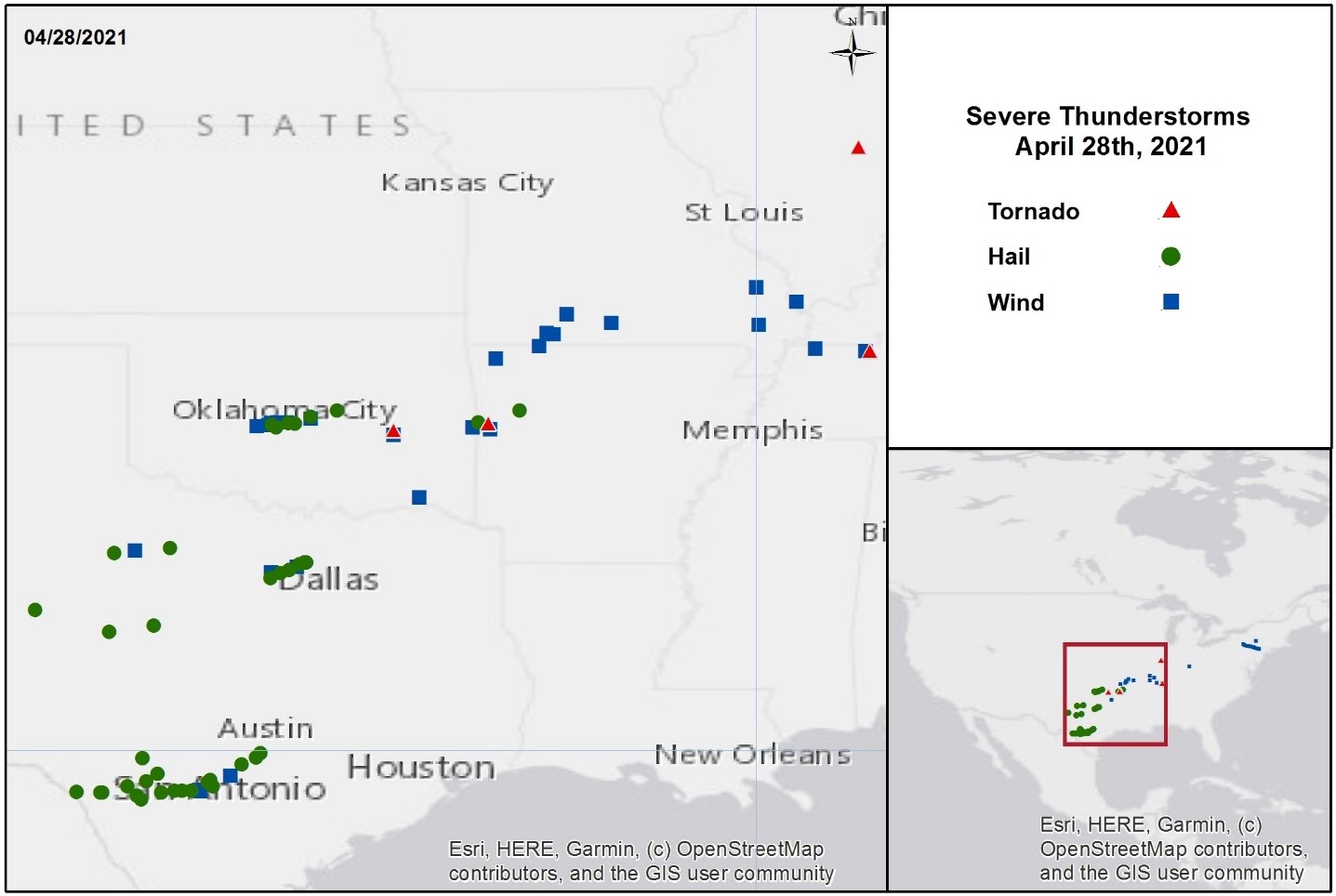
Severe thunderstorm reports from April 28. Source: NOAA/SPC
This report comprises the following sections:
- Regional Impacts
- Meteorological Discussion
Regional Impacts
Texas
Severe impacts from large hail were observed through parts of Texas especially near and due west of San Antonio and the Dallas-Fort Worth Area. Hailstones measuring as large as 3 to 4 inches, the size of baseballs and softballs, were reported in Hondo, just west of San Antonio. Local schools cancelled classes on Thursday as a result of the storms. Along U.S. Highway 90, the metal roof of a convenience store was shredded. Large hail was also reported in North Fort Worth. In Azle, northwest of Fort Worth, storms overturned a mobile home resulting in 3 hospitalizations. Numerous instances of vehicular damage, including dents and cracked or broken windows and windshields, have been recorded across the state as a result of the widespread large hail. In some instances, wind-driven hailstones shattered residential windows and even broke through one roof. In addition to the severe hail, impacts from heavy rain resulted in standing water and more than 20 vehicular crashes with injuries in Tarrant County. As of 6:30 a.m. Thursday morning, more than 30,000 homes and businesses were without power.
Oklahoma
Across the border to the north in Oklahoma, significant hail was also observed in Norman, where KWTV reported a large number of homes, businesses, and vehicles damaged from the hailstorm. Similar to Texas, multiple reports of damaged cars and windows caused sidewalks to be littered with glass. Damage reports continue to evolve, and include damage to a Motel 6, a car dealership, and several of the Norman Police Department’s vehicles. Earlier in the day, an EF-1 tornado was confirmed by the National Weather Service near Stillwell, damaging several homes and barns.
Physical Discussion
- A slow-moving front, spanning from the northern Mid-Atlantic westward to Michigan and then southwest to the Central/Southern Plains, was the focus for organized thunderstorms in Texas and Oklahoma on Wednesday, April 28th.
- Scattered showers first developed in the early afternoon, and rapidly intensified in a moisture rich environment with ample instability and wind shear. The linear band of thunderstorms eventually developed into supercell structures, capable of producing strong winds, large hail, tornadoes and heavy precipitation in a very unstable environment.
- These storms were generally slow moving, and prompted severe weather watches and warnings from San Antonio, TX north to Oklahoma City.
- The biggest impact came in the form of large and destructive hail. Significant hail in excess of two inches diameter was reported in Val Verde, Kinney, Uvalde, Stonewall, Medina and Tarrant Counties in Texas, as well as Grady, McClain, and Cleveland Counties in Oklahoma.
- Destructive hail in excess of three inches diameter as reported in highly populated portions of Tarrant County, Texas. In the meantime, hail of four inches diameter was reported in Medina County, Texas.
- Key areas affected include the Oklahoma City and Dallas-Fort Worth metro areas with hail estimates as shown below.
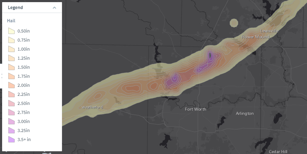
Hail estimates in the Dallas-Fort Worth, Texas area April 28 (as estimated by radar).
Source: GC AdvantagePoint, with data from Northern Illinois University.
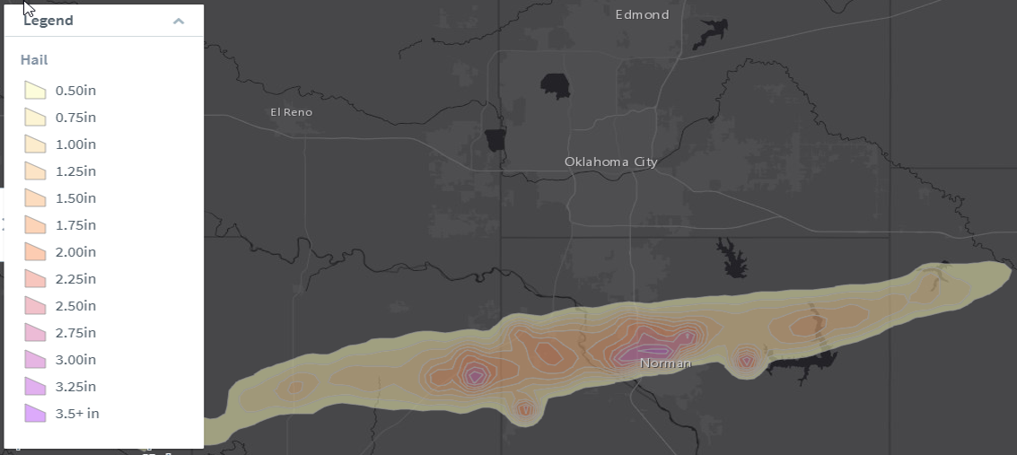
Hail estimates in the Oklahoma City, Oklahoma area April 28 (as estimated by radar).
Source: GC AdvantagePoint, with data from Northern Illinois University.
Context
- The most severely affected areas also suffered severe impacts from winter weather conditions during the middle of February. Excessive cold and winter precipitation caused destructive effects to both property and infrastructure in the Southern Plains.
- Despite a very active pattern earlier in April, tornado, hail and wind reports for the year are all trending below average. Periods of cooler temperatures and the orientation of the storm track have often not been optimal for severe thunderstorm activity.
- Nevertheless, the transition from April to May marks the oncoming peak of severe weather season in the U.S. As warm, moist air from the Gulf of Mexico takes more of a presence in the interior, the boundary between this Gulf air and colder air from Canada will act as a focal point for severe thunderstorm activity as with any spring.
- Academic studies show that during La Nina events, springtime hail and tornado activity tends to be elevated. This is especially true in portions of the Mississippi Valley as shown below. The La Nina event that has been active over the winter months still remains, although the U.S.
- Climate Prediction Center is expecting this to dissipate during the late spring or early summer months.
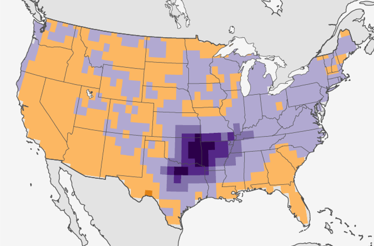
Springtime hail activity during La Nina seasons. Purple shades show an increase relative to average. Source: NOAA, Allen et al., 2015.
Sources: U.S. Storm Prediction Center, U.S. National Weather Service, U.S. Climate Prediction Center, The Weather Channel, CNN, KOCO News 5 (Oklahoma), Allen et al, 2015.